Zürcher Unterland
Encyclopedia

Canton of Zürich
The Canton of Zurich has a population of . The canton is located in the northeast of Switzerland and the city of Zurich is its capital. The official language is German, but people speak the local Swiss German dialect called Züritüütsch...
, including the districts of Bülach
Bülach (district)
Bülach District is one of 12 districts of the Canton of Zürich in Switzerland, with some 117,000 inhabitants the third largest in the canton. Its administrative capital is Bülach, the largest municipality is Kloten, the location of Zurich Airport...
and Dielsdorf.
Geographically, it is located in the Swiss plateau
Swiss plateau
The Swiss Plateau or Central Plateau constitutes one of the three major landscapes in Switzerland alongside the Jura mountains and the Swiss Alps. It covers about 30% of the Swiss surface...
, between the Limmat valley
Limmat Valley
The Limmat Valley is a river valley and a region in the cantons of Zürich and Aargau in Switzerland.- Geography :Limmat is the name of a long river located in the cantons of Zürich and Aargau...
, the city of Zurich
Zürich
Zurich is the largest city in Switzerland and the capital of the canton of Zurich. It is located in central Switzerland at the northwestern tip of Lake Zurich...
and the Zürcher Oberland
Zürcher Oberland
The Zürcher Oberland in Switzerland, is the hilly south-eastern part of the Canton of Zurich, bordering on the Toggenburg, including the districts of Uster, Hinwil, Pfäffikon as well as the Töss Valley as far as the district of Winterthur. The territory gradually fell under the control of the city...
in the south, river Rhine and Germany
Germany
Germany , officially the Federal Republic of Germany , is a federal parliamentary republic in Europe. The country consists of 16 states while the capital and largest city is Berlin. Germany covers an area of 357,021 km2 and has a largely temperate seasonal climate...
in the north. Its limit in the west is the border to the canton Aargau
Aargau
Aargau is one of the more northerly cantons of Switzerland. It comprises the lower course of the river Aare, which is why the canton is called Aar-gau .-History:...
, in the east it ends at the district of Winterthur
Winterthur
Winterthur is a city in the canton of Zurich in northern Switzerland. It has the country's sixth largest population with an estimate of more than 100,000 people. In the local dialect and by its inhabitants, it is usually abbreviated to Winti...
and the Töss river. The elevation range is between the low point of 355m at the Rhine at Eglisau
Eglisau
Eglisau is a municipality in the district of Bülach in the canton of Zürich in Switzerland.-History:Eglisau is first mentioned in 892 as several independent farm houses known as Ouwa. In 1238 it was mentioned as Owe, in 1304 as ze Seglinger Owe, in 1332 as ze Eglins Owe and in 1352 as ze...
, and the high point of 856m on Lägern
Lägern
thumb|300 px|View on Lägern ridgeThe Lägern is the easternmost part of the Swiss Jura, forming the boundary between the cantons of Zurich and Aargau. Its highest elevation is the Burghorn at 859 m....
. Its main part is lying on both sides of the river Glatt
Glatt (Rhine)
Glatt is the name of a lesser affluent to the High Rhine in the Unterland of the canton of Zurich, Switzerland. It is long and flows out from the Greifensee thru the Glatt Valley, discharging into the Rhine by Glattfelden...
.
With the exception of the Rafzerfeld, the entire region came under the government of the city of Zurich
Zürich
Zurich is the largest city in Switzerland and the capital of the canton of Zurich. It is located in central Switzerland at the northwestern tip of Lake Zurich...
in the course of the 15th century (Regensberg and Bülach in 1409, Regensdorf in 1469).
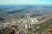
The region has been strongly influenced economically by Zurich Airport since the 1950s, and has been urbanized, forming part of "Greater Zurich".
There are two regional newspapers, the Zürcher Unterländer and the Neues Bülacher Tagblatt.

