
Wright's Ferry Bridge
Encyclopedia
The Wright's Ferry Bridge carries U.S. Route 30
over the Susquehanna River
between Columbia, Pennsylvania
and Wrightsville, Pennsylvania
and commemorates the first ferry
crossing
the Susquehanna (Wright's Ferry
) is therefore (historically) considered a Columbia-Wrightsville Bridge, the fifth, though the fourth Columbia-Wrightsville Bridge
it augments (and might have replaced) is still carrying the Lincoln Highway
, unusually, according to local naming.
. The renamed 'Old Road Name' labels sometimes are given an auxiliary highway designation by the DOT, see Bannered routes of U.S. Route 30
, for such alternate routes. The Route 30 stretch near this bridge must locally be colloquially called New Lincoln Highway, for the local politics retained the Lincoln Highway title on the original roadbed, locally now Pennsylvania Route 462
. The thirty miles of Route 462 are currently labeled on internet digital map software still as the Lincoln Highway.
Also informally known locally as the Route 30 bridge, it was commissioned by the Commonwealth of Pennsylvania in the 1960s to relocate Route 30
and bypass the river towns of Wrightsville and Columbia. Construction started in March 1969 with G.A. & F.C. Wagman, Inc. as the general contractor.
It was completed in 1972 at a cost of $12,000,000 and opened November 21, 1972 under its present commemorative historical name (Wright's Ferry
being both the historic Ferry's
triggered the nine years of armed clashes during Cresap's War
in the border dispute between Maryland and Pennsylvania settled only by the Mason-Dixon Line
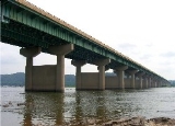
(1767) and, consequently the east bank settlement was long called Wright's Ferry, and so also became one of Columbia's former names. and so one of Columbia's former names). It is constructed of reinforced concrete and steel and has 46 equal sections on 45 piers. U.S. Route 30 crosses it as a divided four-lane roadway. About a year after its opening, the bridge was shut down briefly so that an experimental weather-resistant coating could be applied to its roadway. Tolls were never collected on this bridge, the sixth to cross the river in this general location.
U.S. Route 30
U.S. Route 30 is an east–west main route of the system of United States Numbered Highways, with the highway traveling across the northern tier of the country. It is the third longest U.S. route, after U.S. Route 20 and U.S. Route 6. The western end of the highway is at Astoria, Oregon; the...
over the Susquehanna River
Susquehanna River
The Susquehanna River is a river located in the northeastern United States. At long, it is the longest river on the American east coast that drains into the Atlantic Ocean, and with its watershed it is the 16th largest river in the United States, and the longest river in the continental United...
between Columbia, Pennsylvania
Columbia, Pennsylvania
Columbia, once colonial Wright's Ferry, is a borough in Lancaster County, Pennsylvania, 28 miles southeast of Harrisburg on the left bank Susquehanna River across from Wrightsville and York County. Originally, the area may have been called Conejohela Flats, for the many islands and islets in the...
and Wrightsville, Pennsylvania
Wrightsville, Pennsylvania
Wrightsville is a borough in York County, Pennsylvania, United States. The population was 2,310 at the 2010 census. Wrightsville borough has a police department, historic society, and a volunteer fire company.- History :According to a plaque at Samuel S...
and commemorates the first ferry
Ferry
A ferry is a form of transportation, usually a boat, but sometimes a ship, used to carry primarily passengers, and sometimes vehicles and cargo as well, across a body of water. Most ferries operate on regular, frequent, return services...
crossing
Crossing (river)
A river crossing is a means to get from one river bank to the other and may refer to:* A ford * A bridge* A tunnel* Any type of Ferry** A cable ferry** A reaction ferry** A water taxi-See also::Category:Crossings by river...
the Susquehanna (Wright's Ferry
Wright's Ferry
Wright's Ferry was an animal powered ferry established by John Wright in 1730, and the very first means of crossing the wide unfriendly Susquehanna in the counties of the lower half of the state of Pennsylvaniaand directly triggered Cresap's War between the Province of Maryland and Pennsylvania...
) is therefore (historically) considered a Columbia-Wrightsville Bridge, the fifth, though the fourth Columbia-Wrightsville Bridge
Columbia-Wrightsville Bridge
The Columbia–Wrightsville Bridge, officially the Veterans Memorial Bridge, spanning the Susquehanna River between Columbia and Wrightsville, Pennsylvania, is commonly associated with the name “Columbia–Wrightsville Bridge,” although five other former and present-day bridges share this...
it augments (and might have replaced) is still carrying the Lincoln Highway
Lincoln Highway
The Lincoln Highway was the first road across the United States of America.Conceived and promoted by entrepreneur Carl G. Fisher, the Lincoln Highway spanned coast-to-coast from Times Square in New York City to Lincoln Park in San Francisco, originally through 13 states: New York, New Jersey,...
, unusually, according to local naming.
Old National Pike
Old National Pike or Old National Road, and sometimes Old Cumberland Road, Old Route 40, Old U.S. 40 are terms both colloquially and officially applied to bypassed parts of the United States' first federally funded highway , the National Pikewhich are essentially the parts of U.S. Route 40 west of...
. The renamed 'Old Road Name' labels sometimes are given an auxiliary highway designation by the DOT, see Bannered routes of U.S. Route 30
Bannered routes of U.S. Route 30
Several bannered routes of U.S. Route 30 exist. In order from west to east they are as follows.-Portland bypass:US 30 Bypass is the Northeast Portland Highway No. 123. It runs along the following streets before rejoining US 30 in Fairview:...
, for such alternate routes. The Route 30 stretch near this bridge must locally be colloquially called New Lincoln Highway, for the local politics retained the Lincoln Highway title on the original roadbed, locally now Pennsylvania Route 462
Pennsylvania Route 462
Pennsylvania Route 462 is a long east–west running local route in central Pennsylvania. The western terminus is west of York. The eastern terminus is east of Lancaster. At both ends, PA 462 terminates at U.S. Route 30, and all of the route was signed as U.S. Route 30 before a freeway was...
. The thirty miles of Route 462 are currently labeled on internet digital map software still as the Lincoln Highway.
Also informally known locally as the Route 30 bridge, it was commissioned by the Commonwealth of Pennsylvania in the 1960s to relocate Route 30
U.S. Route 30
U.S. Route 30 is an east–west main route of the system of United States Numbered Highways, with the highway traveling across the northern tier of the country. It is the third longest U.S. route, after U.S. Route 20 and U.S. Route 6. The western end of the highway is at Astoria, Oregon; the...
and bypass the river towns of Wrightsville and Columbia. Construction started in March 1969 with G.A. & F.C. Wagman, Inc. as the general contractor.
It was completed in 1972 at a cost of $12,000,000 and opened November 21, 1972 under its present commemorative historical name (Wright's Ferry
Wright's Ferry
Wright's Ferry was an animal powered ferry established by John Wright in 1730, and the very first means of crossing the wide unfriendly Susquehanna in the counties of the lower half of the state of Pennsylvaniaand directly triggered Cresap's War between the Province of Maryland and Pennsylvania...
being both the historic Ferry's
Wright's Ferry
Wright's Ferry was an animal powered ferry established by John Wright in 1730, and the very first means of crossing the wide unfriendly Susquehanna in the counties of the lower half of the state of Pennsylvaniaand directly triggered Cresap's War between the Province of Maryland and Pennsylvania...
triggered the nine years of armed clashes during Cresap's War
Cresap's War
Cresap's War was a border conflict between Pennsylvania and Maryland, fought in the 1730s...
in the border dispute between Maryland and Pennsylvania settled only by the Mason-Dixon Line
Mason-Dixon line
The Mason–Dixon Line was surveyed between 1763 and 1767 by Charles Mason and Jeremiah Dixon in the resolution of a border dispute between British colonies in Colonial America. It forms a demarcation line among four U.S. states, forming part of the borders of Pennsylvania, Maryland, Delaware, and...
(1767) and, consequently the east bank settlement was long called Wright's Ferry, and so also became one of Columbia's former names. and so one of Columbia's former names). It is constructed of reinforced concrete and steel and has 46 equal sections on 45 piers. U.S. Route 30 crosses it as a divided four-lane roadway. About a year after its opening, the bridge was shut down briefly so that an experimental weather-resistant coating could be applied to its roadway. Tolls were never collected on this bridge, the sixth to cross the river in this general location.
External links
- http://www.rivertownes.org/Features/Crossings/Crossings.htm
- http://www.rivertownes.org/townes.htm