

Ténéré
Encyclopedia
Desert
A desert is a landscape or region that receives an extremely low amount of precipitation, less than enough to support growth of most plants. Most deserts have an average annual precipitation of less than...
region in the south central Sahara
Sahara
The Sahara is the world's second largest desert, after Antarctica. At over , it covers most of Northern Africa, making it almost as large as Europe or the United States. The Sahara stretches from the Red Sea, including parts of the Mediterranean coasts, to the outskirts of the Atlantic Ocean...
. It comprises a vast plain of sand
Sand
Sand is a naturally occurring granular material composed of finely divided rock and mineral particles.The composition of sand is highly variable, depending on the local rock sources and conditions, but the most common constituent of sand in inland continental settings and non-tropical coastal...
stretching from northeastern Niger
Niger
Niger , officially named the Republic of Niger, is a landlocked country in Western Africa, named after the Niger River. It borders Nigeria and Benin to the south, Burkina Faso and Mali to the west, Algeria and Libya to the north and Chad to the east...
into western Chad
Chad
Chad , officially known as the Republic of Chad, is a landlocked country in Central Africa. It is bordered by Libya to the north, Sudan to the east, the Central African Republic to the south, Cameroon and Nigeria to the southwest, and Niger to the west...
, occupying an area of over 154440 square miles (399,997.8 km²). Its boundaries are said to be the Aïr Mountains
Aïr Mountains
The Aïr Mountains is a triangular massif, located in northern Niger, within the Sahara desert...
in the west, the Hoggar Mountains in the north, the Djado Plateau
Djado Plateau
The Djado Plateau lies in the Sahara, in north eastern Niger. It is known for its cave art , but is now largely uninhabited, with abandoned towns and forts visible.- World Heritage Status :...
in the northeast, the Tibesti Mountains
Tibesti Mountains
The Tibesti Mountains are a range of inactive volcanoes located on the northern edge of the Chad Basin in the Borkou- and Tibesti Region of northern Chad. The massif is one of the most prominent features of the Central-Sahara desert and covers an area of approximately 100,000 km². The northern...
in the east, and the basin of Lake Chad
Lake Chad
Lake Chad is a historically large, shallow, endorheic lake in Africa, whose size has varied over the centuries. According to the Global Resource Information Database of the United Nations Environment Programme, it shrank as much as 95% from about 1963 to 1998; yet it also states that "the 2007 ...
in the south. The central part of the desert, the Erg
Erg (landform)
An erg is a broad, flat area of desert covered with wind-swept sand with little or no vegetative cover. The term takes its name from the Arabic word ʿarq , meaning "dune field"...
du Bilma, is centered at approximately 17°35′N 10°55′E.
Name
The name Ténéré comes from the TuaregTuareg languages
Tuareg is a Berber language or family of very closely related languages and dialects spoken by the Tuareg Berbers, in large parts of Mali, Niger, Algeria, Libya and Burkina Faso, with a few speakers, the Kinnin, in Chad.- Description :Other Berber languages and Tamashaq are quite mutually...
language, meaning "desert", in much the same way that the Arabic
Arabic language
Arabic is a name applied to the descendants of the Classical Arabic language of the 6th century AD, used most prominently in the Quran, the Islamic Holy Book...
word for "desert", Sahara
Sahara
The Sahara is the world's second largest desert, after Antarctica. At over , it covers most of Northern Africa, making it almost as large as Europe or the United States. The Sahara stretches from the Red Sea, including parts of the Mediterranean coasts, to the outskirts of the Atlantic Ocean...
, came to be applied to the region as a whole.
Climate
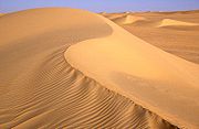
The Ténéré is arid, with an extremely hot and dry climate and virtually no plant life. Temperatures reach as high as 42 °C (108 °F) in the summer, with little more than 25 mm (1 in) of rain annually. Water is notoriously difficult to find, even underground, and wells may be hundreds of miles apart.Topography

Lake Chad
Lake Chad is a historically large, shallow, endorheic lake in Africa, whose size has varied over the centuries. According to the Global Resource Information Database of the United Nations Environment Programme, it shrank as much as 95% from about 1963 to 1998; yet it also states that "the 2007 ...
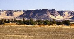
. In the north, the Ténéré is a vast sand sheet - the true, featureless 'Ténéré' of legend reaching up to the low hills of the Tassili du Hoggar along the Algerian border. In the centre the Bilma Erg, forms rows of easily navigable low dunes whose corridors make regular byways for the azelai or salt caravans. To the west, the Aïr Mountains
Aïr Mountains
The Aïr Mountains is a triangular massif, located in northern Niger, within the Sahara desert...
rise up. To the south east the Ténéré is bordered by the Kaour cliffs running 100 km north to south. At the base lie a string of oases including the famous Bilma. The total eclipse of March 2006 passed through this region at which time people in Dirkou were seen running for the mosque.
Periodic outcrops, such as the unusual marble Blue Mountains
Blue Mountains (Niger)
The Blue Mountains are a mountain range in Niger in the northeastern section of the Aïr Massif, about 100 km ENE of the town of Iférouane and 30 km NE of the Tezerik oasis...
in the northwest near Adrar Chiriet, or the Agram hills near the oasis of Fachi
Fachi
Fachi is an oasis surrounded by the Ténéré desert and the dunes of the Erg of Bilma in eastern Niger, placed on the western edge of the small Agram mountain outcropping. It has an estimated population of some 2000 people. A stopping point of the Agadez to Kaouar caravans of the Azalay, Fachi is 150...
and Adrar Madet to the north, are rare but notable landmarks.
History
The region was not always a desert. During the prehistoric CarboniferousCarboniferous
The Carboniferous is a geologic period and system that extends from the end of the Devonian Period, about 359.2 ± 2.5 Mya , to the beginning of the Permian Period, about 299.0 ± 0.8 Mya . The name is derived from the Latin word for coal, carbo. Carboniferous means "coal-bearing"...
period it was a sea floor and later a tropical forest. A major dinosaur
Dinosaur
Dinosaurs are a diverse group of animals of the clade and superorder Dinosauria. They were the dominant terrestrial vertebrates for over 160 million years, from the late Triassic period until the end of the Cretaceous , when the Cretaceous–Paleogene extinction event led to the extinction of...
cemetery lies southeast of Agadez at Gadoufaoua; many fossil
Fossil
Fossils are the preserved remains or traces of animals , plants, and other organisms from the remote past...
s have been found there, having eroded out from the ground. An almost complete specimen of the crocodile
Crocodile
A crocodile is any species belonging to the family Crocodylidae . The term can also be used more loosely to include all extant members of the order Crocodilia: i.e...
-like reptile
Reptile
Reptiles are members of a class of air-breathing, ectothermic vertebrates which are characterized by laying shelled eggs , and having skin covered in scales and/or scutes. They are tetrapods, either having four limbs or being descended from four-limbed ancestors...
Sarcosuchus imperator, nicknamed the SuperCroc, was discovered there by paleontologists.
During early human history, it was a fertile land much more congenial to human life than it is now. The region was inhabited by modern humans as long ago as the Paleolithic
Paleolithic
The Paleolithic Age, Era or Period, is a prehistoric period of human history distinguished by the development of the most primitive stone tools discovered , and covers roughly 99% of human technological prehistory...
period some 60,000 years ago. They hunted wild animals and left evidence of their presence in the form of stone tools including tiny, finely carved arrow heads. During the Neolithic
Neolithic
The Neolithic Age, Era, or Period, or New Stone Age, was a period in the development of human technology, beginning about 9500 BC in some parts of the Middle East, and later in other parts of the world. It is traditionally considered as the last part of the Stone Age...
period about 10,000 years ago, ancient hunters, the Kiffian people, created rock engravings and paintings that can still be found across the region.
The Neolithic Subpluvial
Neolithic Subpluvial
The Neolithic Subpluvial — sometimes called the Holocene Wet Phase — was an extended period of wet and rainy conditions in the climate history of northern Africa...
was an extended metolgical period, from about 7500-7000 BC to about 3500-3000 BC, of relatively wet and rainy conditions in the climate
Climate
Climate encompasses the statistics of temperature, humidity, atmospheric pressure, wind, rainfall, atmospheric particle count and other meteorological elemental measurements in a given region over long periods...
history of northern Africa. It was both preceded and followed by much drier periods. Several archaeological sites that date from this time are dotted across the deserts along the borders of Niger
Niger
Niger , officially named the Republic of Niger, is a landlocked country in Western Africa, named after the Niger River. It borders Nigeria and Benin to the south, Burkina Faso and Mali to the west, Algeria and Libya to the north and Chad to the east...
, Algeria
Algeria
Algeria , officially the People's Democratic Republic of Algeria , also formally referred to as the Democratic and Popular Republic of Algeria, is a country in the Maghreb region of Northwest Africa with Algiers as its capital.In terms of land area, it is the largest country in Africa and the Arab...
and Libya
Libya
Libya is an African country in the Maghreb region of North Africa bordered by the Mediterranean Sea to the north, Egypt to the east, Sudan to the southeast, Chad and Niger to the south, and Algeria and Tunisia to the west....
.. The human population dwindled as the Sahara dried out, and by 2500 BC it had largely become as dry as it is today.
Population
While the well known Tuareg occupy the Aïr Mountains
Aïr Mountains
The Aïr Mountains is a triangular massif, located in northern Niger, within the Sahara desert...
and Agadez
Agadez
-Sources:* Aboubacar Adamou. "Agadez et sa région. Contribution à l'étude du Sahel et du Sahara nigériens", Études nigériennes, n°44, , 358 p.* Julien Brachet. Migrations transsahariennes. Vers un désert cosmopolite et morcelé . Paris: Le Croquant, , 324 p. ISBN : 978-2-91496865-2.*. Saudi Aaramco...
to the west, and still operate the salt caravans for Hausa
Hausa people
The Hausa are one of the largest ethnic groups in West Africa. They are a Sahelian people chiefly located in northern Nigeria and southeastern Niger, but having significant numbers living in regions of Cameroon, Ghana, Cote d'Ivoire, Chad and Sudan...
merchant
Merchant
A merchant is a businessperson who trades in commodities that were produced by others, in order to earn a profit.Merchants can be one of two types:# A wholesale merchant operates in the chain between producer and retail merchant...
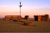
s, the true inhabitants of the Ténéré, found from oases like Fachi
Fachi
Fachi is an oasis surrounded by the Ténéré desert and the dunes of the Erg of Bilma in eastern Niger, placed on the western edge of the small Agram mountain outcropping. It has an estimated population of some 2000 people. A stopping point of the Agadez to Kaouar caravans of the Azalay, Fachi is 150...
eastwards, are the non-Berber Kanuri and Toubou
Toubou
The Tubu are an ethnic group that live mainly in northern Chad, but also in Libya, Niger and Sudan....
, the latter thought to be descended from among the original inhabitants of the Sahara.
Governance
In 1960 the Tuareg territory become part of the independent republic of Niger. It has been divided between seven départments. The central part of the Ténéré is a protected area, under the auspices of the Aïr and Ténéré Natural Reserve.Cities
The "capital" of the Ténéré is the town of AgadezAgadez
-Sources:* Aboubacar Adamou. "Agadez et sa région. Contribution à l'étude du Sahel et du Sahara nigériens", Études nigériennes, n°44, , 358 p.* Julien Brachet. Migrations transsahariennes. Vers un désert cosmopolite et morcelé . Paris: Le Croquant, , 324 p. ISBN : 978-2-91496865-2.*. Saudi Aaramco...
, south of the Aïr Mountains and west of the Tenere. There are also various oasis
Oasis
In geography, an oasis or cienega is an isolated area of vegetation in a desert, typically surrounding a spring or similar water source...
settlements, some like Bilma and Seguedine based on salt production.
Settlements and villages of Ténéré:
- FachiFachiFachi is an oasis surrounded by the Ténéré desert and the dunes of the Erg of Bilma in eastern Niger, placed on the western edge of the small Agram mountain outcropping. It has an estimated population of some 2000 people. A stopping point of the Agadez to Kaouar caravans of the Azalay, Fachi is 150...
- Achegour
- BilmaBilmaBilma is an oasis town in north east Niger with a population of around 2,500 people. It lies protected from the desert dunes under the Kaouar Cliffs and is the largest town along the Kaouar escarpment...
- DirkouDirkouDirkou is a town in the Bilma Department, Agadez Region of north-eastern Niger. It lies in the northern Kaouar escarpment, a north-south line of cliffs which form an isolated oasis in the Sahara desert....
- Chirfa
- Agadem
- SeguedineSéguedineSéguédine is a town in central eastern Niger, lying at the far northern tip of the Kaouar escarpment, an inhabited oasis in the midst of the Sahara desert...
Landmarks
The desert is also known for the celebrated Tree of TénéréArbre du Ténéré
, known in English as the Tree of Ténéré, was a solitary acacia, of either Acacia raddiana or Acacia tortilis, that was once considered the most isolated tree on Earth — the only one for over...
, once thought to be among the most remote in the world. Situated by the last well before entering the Grand Erg du Bilma on the way to Fachi, salt caravans relied on the tree as a landmark until it was allegedly knocked down by a truck driver in 1973. It was replaced by a metal sculpture and the remains are enshrined at the museum in Niamey (capital of Niger). New trees were planted but, because of the very low water table (the adjacent well is some 40m deep), irregular watering by passing travellers saw them fail to survive. Despite this unfortunate mishap, the tree is still often indicated on maps of the region as a notable landmark, as is the less well known Arbre Perdu (Lost Tree) situated in the true Tenere to the north, east of Chirfa.
See also
- Aïr and Ténéré National Nature ReserveAïr and Ténéré National Nature ReserveThe Aïr and Ténéré National Nature Reserve is a national nature reserve in the West African nation of Niger. It includes several overlapping reserve designations, and is designated a UNESCO World Heritage Site...
- GermaGermaGerma, known in ancient times as Garama, is an archaeological site in Libya and was the capital of the Garamantes.The Garamantes were a Berber people living in the Fezzan in the northeastern Sahara, originating from the Sahara's Tibesti region. Garamantian power climaxed during the 2nd and the 3rd...
- Green Sahara
- The Ténéré motorbikeYamaha XTZ 750The Yamaha XTZ 750 SuperTénéré is a dual-sport motorcycle, produced by Yamaha. It was named after Yamaha's lighter, single-cylinder models which in turn were named after the notorious Ténéré desert stage of the former Paris-Dakar Rally in northeastern Niger.-Background:The XTZ 750 is a larger,...