

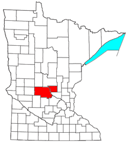
St. Cloud metropolitan area
Encyclopedia
United States Census Bureau
The United States Census Bureau is the government agency that is responsible for the United States Census. It also gathers other national demographic and economic data...
, is an area consisting of two counties in central
Central Minnesota
Central Minnesota is the name of the region consisting of the central portion of the state of Minnesota. Although no specific boundaries of the region exist, most definitions of what makes up the region would generally consist of the vast swath of land north of Interstate 94, east of U.S. Highway...
Minnesota
Minnesota
Minnesota is a U.S. state located in the Midwestern United States. The twelfth largest state of the U.S., it is the twenty-first most populous, with 5.3 million residents. Minnesota was carved out of the eastern half of the Minnesota Territory and admitted to the Union as the thirty-second state...
, anchored by the city of St. Cloud
St. Cloud, Minnesota
St. Cloud is a city in the U.S. state of Minnesota and the largest population center in the state's central region. The population was 65,842 at the 2010 census. It is the county seat of Stearns County...
. As of the 2000 census
United States Census, 2000
The Twenty-second United States Census, known as Census 2000 and conducted by the Census Bureau, determined the resident population of the United States on April 1, 2000, to be 281,421,906, an increase of 13.2% over the 248,709,873 persons enumerated during the 1990 Census...
, the MSA had a population of 167,392 (though a July 1, 2009 estimate placed the population at 189,148).
The St. Cloud Metropolitan Statistical Area is part of the Minneapolis
Minneapolis, Minnesota
Minneapolis , nicknamed "City of Lakes" and the "Mill City," is the county seat of Hennepin County, the largest city in the U.S. state of Minnesota, and the 48th largest in the United States...
–St. Paul, MN-WI
Wisconsin
Wisconsin is a U.S. state located in the north-central United States and is part of the Midwest. It is bordered by Minnesota to the west, Iowa to the southwest, Illinois to the south, Lake Michigan to the east, Michigan to the northeast, and Lake Superior to the north. Wisconsin's capital is...
Combined Statistical Area.
Places with more than 50,000 inhabitants
- St. CloudSt. Cloud, MinnesotaSt. Cloud is a city in the U.S. state of Minnesota and the largest population center in the state's central region. The population was 65,842 at the 2010 census. It is the county seat of Stearns County...
(Principal city; partial)
Places with 5,000 to 15,000 inhabitants
- SartellSartell, MinnesotaSartell is a city in Benton and Stearns counties in the U.S. state of Minnesota. It is part of the St. Cloud Metropolitan Statistical Area. The population was 15,876 at the 2010 census, making it St. Cloud's most populous suburb and the largest city in the central Minnesota region after St...
- Sauk RapidsSauk Rapids, MinnesotaAs of the census of 2000, there were 10,213 people, 3,921 households, and 2,599 families residing in the city. The population density was 2,234.1 people per square mile . There were 4,017 housing units at an average density of 878.7 per square mile...
- Waite ParkWaite Park, MinnesotaAs of the census of 2000, there were 6,568 people, 2,967 households, and 1,536 families residing in the city. The population density was 841.0 people per square mile . There were 3,065 housing units at an average density of 392.5 per square mile...
- St. JosephSt. Joseph, MinnesotaAs of the census of 2000, there were 4,681 people, 1,120 households, and 712 families residing in the city. The population density was 2,517.4 people per square mile . There were 1,147 housing units at an average density of 616.8 per square mile...
Places with 1,000 to 5,000 inhabitants
- AlbanyAlbany, MinnesotaAs of the census of 2000, there were 1,796 people, 708 households, and 436 families residing in the city. The population density was 1,287.6 people per square mile . There were 732 housing units at an average density of 524.8 per square mile...
- AvonAvon, MinnesotaAvon is a city in Stearns County, Minnesota, United States. The population was 1,396 at the 2010 census. It is part of the St. Cloud Metropolitan Statistical Area....
- Cold SpringCold Spring, MinnesotaAs of the census of 2000, there were 2,975 people, 1,116 households, and 785 families residing in the city. The population density was 1,431.1 people per square mile . There were 1,145 housing units at an average density of 550.8 per square mile...
- FoleyFoley, MinnesotaAs of the census of 2000, there were 2,154 people, 756 households, and 499 families residing in the city. The population density was 1,148.6 people per square mile . There were 793 housing units at an average density of 422.8 per square mile...
- MelroseMelrose, MinnesotaMelrose is a city in Stearns County, Minnesota, United States. The population was 3,598 at the 2010 census. It is part of the St. Cloud Metropolitan Statistical Area.-Geography:...
- PaynesvillePaynesville, MinnesotaAs of the census of 2000, there were 2,267 people, 934 households, and 594 families residing in the city. The population density was 1,715.2 people per square mile . There were 984 housing units at an average density of 744.5 per square mile...
- RichmondRichmond, MinnesotaRichmond is a city in Stearns County, Minnesota, United States. The population was 1,422 at the 2010 census. Richmond is part of the St. Cloud Metropolitan Statistical Area.-Geography:...
- Sauk CentreSauk Centre, MinnesotaAs of the census of 2000, there were 3,930 people, 1,616 households, and 1,042 families residing in the city. The population density was 1,057.2 people per square mile . There were 1,709 housing units at an average density of 459.7 per square mile...
- St. AugustaSt. Augusta, MinnesotaSaint Augusta is a city in Stearns County, Minnesota, directly south of the city of St. Cloud. The population was 3,317 at the 2010 census. Originally Saint Augusta Township, it incorporated as a city on May 2, 2000 in order to avoid annexation by the city of Saint Cloud.For a short time Saint...
Places with 500 to 1,000 inhabitants
- BelgradeBelgrade, MinnesotaBelgrade is a town in Stearns County, Minnesota, United States. The population was 740 at the 2010 census. It is part of the St. Cloud Metropolitan Statistical Area.-Geography:...
- BrootenBrooten, MinnesotaAs of the census of 2000, there were 649 people, 278 households, and 167 families residing in the city. The population density was 446.7 people per square mile . There were 338 housing units at an average density of 232.7 per square mile...
(partial) - ClearwaterClearwater, MinnesotaAs of the census of 2000, there were 858 people, 327 households, and 223 families residing in the city. The population density was 740.9 people per square mile . There were 355 housing units at an average density of 306.5 per square mile...
(partial) - Eden ValleyEden Valley, MinnesotaEden Valley is a city in Meeker and Stearns counties in the U.S. state of Minnesota. The population was 1,042 at the 2010 census. Most of Eden Valley is located in Meeker County.The Stearns County portion of Eden Valley is part of the St...
(partial) - HoldingfordHoldingford, MinnesotaHoldingford is a city in Stearns County, Minnesota, United States. The population was 708 at the 2010 census. It claims to be "The Gateway to Lake Wobegon", the fictional central Minnesota town created by Garrison Keillor.Holdingford is part of the St...
- KimballKimball, MinnesotaAs of the census of 2000, there were 635 people, 262 households, and 165 families residing in the city. The population density was 459.0 people per square mile . There were 280 housing units at an average density of 202.4 per square mile...
- RiceRice, MinnesotaAs of the census of 2000, there were 711 people, 247 households, and 185 families residing in the city. The population density was 118.8 people per square mile . There were 250 housing units at an average density of 41.8 per square mile . The racial makeup of the city was 98.87% White, 0.70% Native...
- RockvilleRockville, MinnesotaRockville is a city in Stearns County, Minnesota, United States. The population was 2,448 at the 2010 census. It is part of the St. Cloud Metropolitan Statistical Area....
- RoyaltonRoyalton, MinnesotaAs of the census of 2000, there were 816 people, 322 households, and 209 families residing in the city. The population density was 473.7 people per square mile . There were 328 housing units at an average density of 190.4 per square mile . The racial makeup of the city was 98.77% White, 0.25%...
(partial) - St. StephenSt. Stephen, MinnesotaSaint Stephen is a city in Stearns County, Minnesota, United States. The population was 860 at the 2000 census. It is part of the Saint Cloud Metropolitan Statistical Area.-Geography:...
Places with less than 500 inhabitants
- ElrosaElrosa, MinnesotaElrosa is a city in Stearns County, Minnesota, United States. The population was 211 at the 2010 census. It is part of the St. Cloud Metropolitan Statistical Area.-Geography:...
- FreeportFreeport, MinnesotaFreeport is a city in Stearns County, Minnesota, United States. The population was 632 at the 2010 census. It is part of the St. Cloud Metropolitan Statistical Area.-Geography:Freeport is located in Oak Township, T125N R32W §3...
- GilmanGilman, MinnesotaGilman is a city in Benton County, Minnesota, United States. The population was 224 at the 2010 census. It is part of the St. Cloud Metropolitan Statistical Area.-Geography:...
- GreenwaldGreenwald, MinnesotaGreenwald is a city in Stearns County, Minnesota, USA. The population was 222 at the 2010 census. It is part of the St. Cloud Metropolitan Statistical Area....
- Lake HenryLake Henry, MinnesotaLake Henry is a city in Stearns County, Minnesota, United States. The population was 103 at the 2010 census. It is part of the St. Cloud Metropolitan Statistical Area.Minnesota State Highway 4 serves as a main arterial route in the community.-Geography:...
- Meire GroveMeire Grove, MinnesotaMeire Grove is a city in Grove Township, Stearns County, Minnesota, United States. The population was 179 at the 2010 census. It is part of the St...
- New MunichNew Munich, MinnesotaNew Munich is a city in Stearns County, Minnesota, United States. The population was 320 at the 2010 census. It is part of the St. Cloud Metropolitan Statistical Area.-Geography:...
- RonnebyRonneby, MinnesotaRonneby is an unincorporated community in sections 19 and 20 of Maywood Township, Benton County, Minnesota, United States. It is part of the Saint Cloud Metropolitan Statistical Area.-History:...
- RoscoeRoscoe, MinnesotaRoscoe is a city in Stearns County, Minnesota, United States. The population was 102 at the 2010 census. It is part of the St. Cloud Metropolitan Statistical Area.-Geography:...
- Spring HillSpring Hill, MinnesotaSpring Hill is a city in Stearns County, Minnesota, USA. The population was 85 at the 2010 census. It is part of the St. Cloud Metropolitan Statistical Area.Minnesota State Highway 4 serves as a main arterial route in the community.-Geography:...
- St. AnthonySt. Anthony, Stearns County, MinnesotaSt. Anthony is a city in Stearns County, Minnesota, United States. The population was 86 at the 2010 census. It is part of the St. Cloud Metropolitan Statistical Area.Minnesota State Highway 238 serves as one of the main routes in the community.-Geography:...
- St. MartinSt. Martin, MinnesotaSt. Martin is a city in Stearns County, Minnesota, United States. The population was 278 at the 2000 census. It is part of the St. Cloud Metropolitan Statistical Area.-Geography:...
- St. RosaSt. Rosa, MinnesotaSaint Rosa is a city in Stearns County, Minnesota, United States. The population was 44 at the 2000 census. It is part of the St. Cloud Metropolitan Statistical Area.-Geography:...
Unincorporated places
|
Oak Park, Minnesota Oak Park is an unincorporated community in Benton County, Minnesota, United States. Oak Park is located on Minnesota State Highway 23 northeast of Foley. Oak Park has a post office with ZIP code 56357.... |
Benton County
|
|
Stearns County
|
St. Joseph Township, Stearns County, Minnesota St. Joseph Township is a township in Stearns County, Minnesota, United States. The population was 2,449 at the 2000 census. The township borders the western side of the cities of St. Cloud and Waite Park, and completely surrounds the city of St. Joseph. All are components of the St... |
Demographics
As of the censusCensus
A census is the procedure of systematically acquiring and recording information about the members of a given population. It is a regularly occurring and official count of a particular population. The term is used mostly in connection with national population and housing censuses; other common...
of 2000, there were 167,392 people, 60,669 households, and 40,650 families residing within the MSA. The racial makeup of the MSA was 96.04% White, 0.82% African American, 0.31% Native American, 1.49% Asian, 0.04% Pacific Islander, 0.45% from other races
Race (United States Census)
Race and ethnicity in the United States Census, as defined by the Federal Office of Management and Budget and the United States Census Bureau, are self-identification data items in which residents choose the race or races with which they most closely identify, and indicate whether or not they are...
, and 0.84% from two or more races. Hispanic or Latino of any race were 1.27% of the population.
The median income for a household in the MSA was $42,197, and the median income for a family was $51,415. Males had a median income of $33,741 versus $23,065 for females. The per capita income
Per capita income
Per capita income or income per person is a measure of mean income within an economic aggregate, such as a country or city. It is calculated by taking a measure of all sources of income in the aggregate and dividing it by the total population...
for the MSA was $19,110.