
St. Anthony, New Orleans
Encyclopedia
St. Anthony is a neighborhood
of the city of New Orleans
. A subdistrict of the Gentilly District Area, its boundaries as defined by the City Planning Commission are: New York Street to the north, Elysian Fields Avenue
to the east, Mirabeau Avenue to the south and the London Avenue Canal
to the west.
The neighborhood is part of the Gentilly section
of the city as well as the city's 7th Ward
.
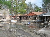
The area experienced disastrous flooding at the end of August 2005 from a levee failure on the London Avenue Canal during Hurricane Katrina.
, the district has a total area of 0.63 mi2. 0.63 mi2 of which is land and 0 mi2 (0.0%) of which is water.
of 2000, there were 5,318 people, 2,233 households, and 1,360 families residing in the neighborhood. The population density
was 8,441 /mi² (3,324 /km²).
New Orleans neighborhoods
In 1980 the New Orleans City Planning Commission divided the city into 13 planning districts and 72 distinct neighborhoods.While most of these assigned boundaries match with traditional local designations, some others differ from common traditional use...
of the city of New Orleans
New Orleans, Louisiana
New Orleans is a major United States port and the largest city and metropolitan area in the state of Louisiana. The New Orleans metropolitan area has a population of 1,235,650 as of 2009, the 46th largest in the USA. The New Orleans – Metairie – Bogalusa combined statistical area has a population...
. A subdistrict of the Gentilly District Area, its boundaries as defined by the City Planning Commission are: New York Street to the north, Elysian Fields Avenue
Elysian Fields Avenue
Elysian Fields Avenue is a broad, straight avenue in New Orleans named after the Avenue des Champs-Élysées in Paris. It courses south to north from the Lower Mississippi River to Lake Pontchartrain, a distance of approximately . The avenue intersects with Interstate 610, Interstate 10, and U.S....
to the east, Mirabeau Avenue to the south and the London Avenue Canal
London Avenue Canal
The London Avenue Canal is a drainage canal in New Orleans, Louisiana, used for pumping rain water into Lake Pontchartrain. The Canal runs through the 7th Ward of New Orleans from the Gentilly area to the Lakefront....
to the west.
The neighborhood is part of the Gentilly section
Gentilly, New Orleans
Gentilly is a broad, predominantly middle-class and racially diverse section of New Orleans, Louisiana. The first part of Gentilly to be developed was along the Gentilly Ridge, a long stretch of high ground along the former banks of Bayou Gentilly...
of the city as well as the city's 7th Ward
7th Ward of New Orleans
The 7th Ward is a section of New Orleans, Louisiana. It is geographically the second largest of the 17 Wards of New Orleans, after the 9th Ward.-Boundaries and geography:...
.
The area experienced disastrous flooding at the end of August 2005 from a levee failure on the London Avenue Canal during Hurricane Katrina.
Geography
St. Anthony is located at 30°00′54"N 90°03′55"W and has an elevation of 0 foot (0 m). According to the United States Census BureauUnited States Census Bureau
The United States Census Bureau is the government agency that is responsible for the United States Census. It also gathers other national demographic and economic data...
, the district has a total area of 0.63 mi2. 0.63 mi2 of which is land and 0 mi2 (0.0%) of which is water.
Adjacent Neighborhoods
- Lake Terrace/Lake OaksLake Terrace/Lake Oaks, New OrleansLake Terrace/Lake Oaks is a neighborhood of the city of New Orleans. A subdistrict of the city's Gentilly District Area, its boundaries as defined by the City Planning Commission are: Lake Pontchartrain to the north, the Industrial Canal to the east, Leon C. Simon Drive, Elysian Fields Avenue, New...
(north) - Milneburg (east)
- Gentilly TerraceGentilly Terrace, New OrleansGentilly Terrace is a neighborhood of the city of New Orleans. A subdistrict of the Gentilly District Area, its boundaries as defined by the City Planning Commission are: Filmore Avenue to the north, People's Avenue to the east, Dahlia Walk and Benefit Street to the south and Elysian Fields Avenue...
(east) - DillardDillard, New OrleansDillard is a neighborhood of the city of New Orleans. A subdistrict of the Gentilly District Area, its boundaries as defined by the City Planning Commission are: Mirabeau Avenue to the north, Elysian Fields Avenue to the east, Benefit Street and I-610 to the south and Paris Avenue, Pratt Drive and...
(south) - FilmoreFilmore, New OrleansFilmore is a neighborhood of the city of New Orleans. A subdistrict of the Gentilly District Area, its boundaries as defined by the City Planning Commission are: Robert E. Lee Boulevard to the north, London Avenue Canal to the east, Press Drive, Paris Avenue and Harrison Avenue to the south and...
(west)
Boundaries
The City Planning Commission defines the boundaries of St. Anthony as these streets: New York Street, Elysian Fields Avenue, Mirabeau Avenue and the London Avenue Canal.Demographics
As of the censusCensus
A census is the procedure of systematically acquiring and recording information about the members of a given population. It is a regularly occurring and official count of a particular population. The term is used mostly in connection with national population and housing censuses; other common...
of 2000, there were 5,318 people, 2,233 households, and 1,360 families residing in the neighborhood. The population density
Population density
Population density is a measurement of population per unit area or unit volume. It is frequently applied to living organisms, and particularly to humans...
was 8,441 /mi² (3,324 /km²).