
Puerto Boyacá
Encyclopedia
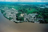
Puerto Boyacá is a Colombia
n river-port town and municipality by the Magdalena River
in the Boyacá Department
, where is also considered a Special Handling Zone due to its port status. Its main industries are oil exploration and processing. In the 1980s and early 1990s Puerto Boyacá was affected intensively by the Colombian Armed Conflict
.
Colombia
Colombia, officially the Republic of Colombia , is a unitary constitutional republic comprising thirty-two departments. The country is located in northwestern South America, bordered to the east by Venezuela and Brazil; to the south by Ecuador and Peru; to the north by the Caribbean Sea; to the...
n river-port town and municipality by the Magdalena River
Magdalena River
The Magdalena River is the principal river of Colombia, flowing northward about through the western half of the country. It takes its name from the biblical figure Mary Magdalene. It is navigable through much of its lower reaches, in spite of the shifting sand bars at the mouth of its delta, as...
in the Boyacá Department
Boyacá Department
Boyacá is one of the 32 Departments of Colombia, and the remnant of one of the original nine states of the "United States of Colombia".Boyacá is centrally located within Colombia, almost entirely within the mountains of the Eastern Cordillera to the border with Venezuela, although the western end...
, where is also considered a Special Handling Zone due to its port status. Its main industries are oil exploration and processing. In the 1980s and early 1990s Puerto Boyacá was affected intensively by the Colombian Armed Conflict
Colombian Armed Conflict
The Colombian armed conflict or Colombian Civil War are terms that are employed to refer to the current asymmetric low-intensity armed conflict in Colombia that has existed since approximately 1964 or 1966, between the Colombian government and peasant guerrillas such as the Revolutionary Armed...
.
Borders
- North with Bolívar, Santander Department
- West Magdalena river with separate of Puerto Berrío, Puerto Nare, Puerto Triunfo and Sonson municipalities of Antioquia Department
- South with Puerto Salgar and Yacopí municipalities of Cundinamarca Department
- East Municipality of Otanche (Boyacá department)
Another Facts
- Market Day: Sunday
- Distance from Tunja: 373 km
- Elevation: 150 m
- Extensión: 1472 km²
- Median temperature: 32 °C
- Demonym: Puerto Boyacenses
External links
- Puerto Boyaca Municipality official Site (Spanish)