
Pu'u 'O'o
Encyclopedia
Puu Ōō is a cinder/spatter cone
in the eastern rift zone
of the Kīlauea
volcano
of the Hawaiian Islands
. Puu Ōō has been erupting continuously since January 3, 1983, making it the longest-lived rift-zone eruption of the last two centuries.
Although the name is often translated as "Hill of the Ōō Bird" from Hawaiian
, there is a different explanation of the Hawaiian appellation. The word Ōō also means digging stick. Because in Hawaiian legends the volcano goddess Pele
uses her magic rod pāoa to create volcanic pits, this seems to be the intention for the naming. The cone was originally informally called "Puu O" by volcanologists, who simply assigned letters to vents as they arose during the first part of the eruption.
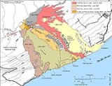
By January 2005, 2.7 cubic kilometre (0.647764448231574 cu mi) of magma covered an area of more than 117 square kilometre and added 230 acre (0.9307778 km²) of land to the Southeast coast of Hawaii
. So far, the eruption has claimed 189 buildings and 14 kilometres (8.7 mi) of highways, as well as a church, a store, the Wahaula Visitor Center, and many ancient Hawaiian sites, including the Wahaula heiau
. The coastal highway has been closed since 1987, as it has been buried under lava up to 35 metres (114.8 ft) thick.
In July 1986, the conduit feeding magma
to Puu Ōō ruptured, and the eruption abruptly shifted 3 kilometres (1.9 mi) downrift to form the Kūpaianahā vent. With the new vent came a new style of eruption: continuous, quiet effusion from a lava lake
replaced the episodic high fountaining. After a few weeks, a roof formed over the main lava outflow channel, which created a lava tube
. The lava tube allowed the fluid pahoehoe lava to retain heat and flow long distances. In less than a year, overflow from the lake created a broad and low shield about 55 metres (180.4 ft) above Kūpaianahā.
Lava streams were first visible from the town of Kapaahu in November, 1986. In the course of that month, lava cut a swath through Kapaahu, covered the coastal highway, and finally reached the ocean 12 kilometres (7.5 mi) from the vent. Some weeks later, the lava flow shifted eastwards and buried 14 houses in the town of Kalapana within one day. The lava flow at Kalapana ceased when the lava tube system shut down.
 In 1990, the eruption entered its most destructive phase when flows turned eastward and totally destroyed the villages of Kalapana and Kaimū. Kaimū Bay and Kalapana Black Sand Beach were also completely covered with lava. Over 100 homes were destroyed by the ever-broadening flow field in a nine-month period. New tubes diverted lava away from Kalapana early in 1991, and lava once again entered the ocean within the Hawaii Volcanoes National Park
. The volume of lava erupted from Kūpaianahā declined steadily through 1991, and in early 1992 the vent died. The eruption then returned to Puu Ōō, where flank vents on the west and southwest sides of the cone constructed a new lava shield. Soon lava tubes were feeding lava from the vents to the ocean, with few surface flows in between. The flank vents have held center stage ever since, with the exception of a two-month pause in activity early in 1997 that followed a brief fissure eruption in Nāpau Crater, a short distance southwest of Puu Ōō.
On the evening of January 29, 1997, a series of earthquake
s struck Kīlauea's east rift zone. Deep within the rift zone, magma
was escaping from the conduit leading to the Puu Ōō vent, cutting off the supply to the ongoing eruption. The lava pond at Puu Ōō drained, and residents 10 miles (16.1 km) away heard a low, rumbling roar as the crater floor dropped 500 feet (150 m) and the west wall of the Puu Ōō cone collapsed. A few hours later, as magma found a new path to the surface, the ground cracked in nearby Nāpau Crater, and lava fountains lit up the night sky. However, activity in this area was short-lived, and the center of activity soon shifted back to Puu Ōō.
 As of January 2007, 3.1 cubic km of lava had covered 117 km2 (45 mi2) and added 201 hectares (500 acres) to Kīlauea's southern shore. The new shoreline is 15.6 km (9.7 mi) long. The lava flows have destroyed 189 structures and covered 14 km (8.7 mi) of highway with as much as 35 m (115 ft) of lava.
In 2007, after a cluster of earthquakes, activity in Puu Ōō subsided and the crater floor collapsed, with no incandescence visible in the crater after the end of August. Lava began emerging from a series of cracks in the northeast rift zone and spread slowly east and south as a perched flow, with slow advances of aā. The flow spread mostly over flows of 1983-1986, with minor incursions into adjoining forest.
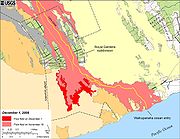 In late July 2008, additional flows extended from the eastern vents of Puu Ōō and in October multiple new fissures opened along the length of the tube expanding into Royal Gardens Subdivision and covered a large area of the coastal flats in November, 2008.
On March 26, 2011, lava began to refill the crater's floor being visible in USGS HVO
webcam. USGS states that accumulation of lava has put the crater floor about 39 m (130 ft) below the eastern crater rim as of June 1.
On September 21, 2011, lava in the W lava lake in Pu'u 'O'o Crater fed a series of lava flows that traveled down the W flank of Pu'u 'O'o during 20-21 September. At about 0225 on 21 September activity in the crater and overflows to the W suddenly decreased, as lava broke through the upper E flank of Pu'u 'O'o, bypassing the crater. The new fissure fed a channelized 'a'a lava flow that advanced rapidly downslope 2.5 km SE. A second flow to the W of the first began the next day. In addition, a small pad of lava actively refilled the bottom of the drained E lava lake and small flows were barely active at the W edge of Pu'u 'O'o Crater. The channelized 'a'a lava flow reached 3.7 km long on 23 September and then stalled within the Kahauale'a Natural Area Reserve. Most of the active lava spread S and W of Pu'u Halulu (1.3 km NE of Pu'u 'O'o) during 23-27 September. Minor lava activity resumed within Pu'u 'O'o Crater with short lava flows issuing from the base of the E wall on 25 September and from the W wall base during 25-26 September. The crater floor of Pu'u 'O'o slowly subsided. Lava activity resumed within the E lake on 26 September. The floor of the crater continued to subside during 26-27 September, opening up cracks in the N crater floor. and
Volcanic cone
Volcanic cones are among the simplest volcanic formations. They are built by ejecta from a volcanic vent, piling up around the vent in the shape of a cone with a central crater. Volcanic cones are of different types, depending upon the nature and size of the fragments ejected during the eruption...
in the eastern rift zone
Rift zone
A rift zone is a feature of some volcanoes, especially the shield volcanoes of Hawaii, in which a linear series of fissures in the volcanic edifice allows lava to be erupted from the volcano's flank instead of from its summit...
of the Kīlauea
Kilauea
Kīlauea is a volcano in the Hawaiian Islands, and one of five shield volcanoes that together form the island of Hawaii. Kīlauea means "spewing" or "much spreading" in the Hawaiian language, referring to its frequent outpouring of lava. The Puu Ōō cone has been continuously erupting in the eastern...
volcano
Volcano
2. Bedrock3. Conduit 4. Base5. Sill6. Dike7. Layers of ash emitted by the volcano8. Flank| 9. Layers of lava emitted by the volcano10. Throat11. Parasitic cone12. Lava flow13. Vent14. Crater15...
of the Hawaiian Islands
Hawaiian Islands
The Hawaiian Islands are an archipelago of eight major islands, several atolls, numerous smaller islets, and undersea seamounts in the North Pacific Ocean, extending some 1,500 miles from the island of Hawaii in the south to northernmost Kure Atoll...
. Puu Ōō has been erupting continuously since January 3, 1983, making it the longest-lived rift-zone eruption of the last two centuries.
Although the name is often translated as "Hill of the Ōō Bird" from Hawaiian
Hawaiian language
The Hawaiian language is a Polynesian language that takes its name from Hawaii, the largest island in the tropical North Pacific archipelago where it developed. Hawaiian, along with English, is an official language of the state of Hawaii...
, there is a different explanation of the Hawaiian appellation. The word Ōō also means digging stick. Because in Hawaiian legends the volcano goddess Pele
Pele (mythology)
In the Hawaiian religion, Pele is the goddess of fire, lightning, wind, and volcanoes. She is a popular figure in many stories of ancient Hawaii known as Hawaiian mythology.-Legends:...
uses her magic rod pāoa to create volcanic pits, this seems to be the intention for the naming. The cone was originally informally called "Puu O" by volcanologists, who simply assigned letters to vents as they arose during the first part of the eruption.
By January 2005, 2.7 cubic kilometre (0.647764448231574 cu mi) of magma covered an area of more than 117 square kilometre and added 230 acre (0.9307778 km²) of land to the Southeast coast of Hawaii
Hawaii (island)
The Island of Hawaii, also called the Big Island or Hawaii Island , is a volcanic island in the North Pacific Ocean...
. So far, the eruption has claimed 189 buildings and 14 kilometres (8.7 mi) of highways, as well as a church, a store, the Wahaula Visitor Center, and many ancient Hawaiian sites, including the Wahaula heiau
Heiau
A heiau is a Hawaiian temple. Many types of heiau existed, including heiau to treat the sick , offer first fruits, offer first catch, start rain, stop rain, increase the population, ensure health of the nation, achieve success in distant voyaging, reach peace, and achieve success in war . Only the...
. The coastal highway has been closed since 1987, as it has been buried under lava up to 35 metres (114.8 ft) thick.
Puu Ōō-Kūpaianahā eruption
The Puu Ōō eruption began when fissures split the ground in the remote rainforest of the eastern rift zone. By June 1983, the activity had strengthened and localized to the Puu Ōō vent. Over the next three years, 44 eruptive episodes with lava fountains as high as 460 metres (1,509.2 ft) stopped traffic at points across east Hawaii. The fallout of cinder and spatter from the towering lava fountains built a cone 255 metres (836.6 ft) high.In July 1986, the conduit feeding magma
Magma
Magma is a mixture of molten rock, volatiles and solids that is found beneath the surface of the Earth, and is expected to exist on other terrestrial planets. Besides molten rock, magma may also contain suspended crystals and dissolved gas and sometimes also gas bubbles. Magma often collects in...
to Puu Ōō ruptured, and the eruption abruptly shifted 3 kilometres (1.9 mi) downrift to form the Kūpaianahā vent. With the new vent came a new style of eruption: continuous, quiet effusion from a lava lake
Lava lake
Lava lakes are large volumes of molten lava, usually basaltic, contained in a volcanic vent, crater, or broad depression. The term is used to describe both lava lakes that are wholly or partly molten and those that are solidified...
replaced the episodic high fountaining. After a few weeks, a roof formed over the main lava outflow channel, which created a lava tube
Lava tube
Lava tubes are natural conduits through which lava travels beneath the surface of a lava flow, expelled by a volcano during an eruption. They can be actively draining lava from a source, or can be extinct, meaning the lava flow has ceased and the rock has cooled and left a long, cave-like...
. The lava tube allowed the fluid pahoehoe lava to retain heat and flow long distances. In less than a year, overflow from the lake created a broad and low shield about 55 metres (180.4 ft) above Kūpaianahā.
Lava streams were first visible from the town of Kapaahu in November, 1986. In the course of that month, lava cut a swath through Kapaahu, covered the coastal highway, and finally reached the ocean 12 kilometres (7.5 mi) from the vent. Some weeks later, the lava flow shifted eastwards and buried 14 houses in the town of Kalapana within one day. The lava flow at Kalapana ceased when the lava tube system shut down.
Hawaii Volcanoes National Park
Hawaii Volcanoes National Park, established in 1916, is a United States National Park located in the U.S. State of Hawaii on the island of Hawaii. It encompasses two active volcanoes: Kīlauea, one of the world's most active volcanoes, and Mauna Loa, the world's most massive volcano...
. The volume of lava erupted from Kūpaianahā declined steadily through 1991, and in early 1992 the vent died. The eruption then returned to Puu Ōō, where flank vents on the west and southwest sides of the cone constructed a new lava shield. Soon lava tubes were feeding lava from the vents to the ocean, with few surface flows in between. The flank vents have held center stage ever since, with the exception of a two-month pause in activity early in 1997 that followed a brief fissure eruption in Nāpau Crater, a short distance southwest of Puu Ōō.
On the evening of January 29, 1997, a series of earthquake
Earthquake
An earthquake is the result of a sudden release of energy in the Earth's crust that creates seismic waves. The seismicity, seismism or seismic activity of an area refers to the frequency, type and size of earthquakes experienced over a period of time...
s struck Kīlauea's east rift zone. Deep within the rift zone, magma
Magma
Magma is a mixture of molten rock, volatiles and solids that is found beneath the surface of the Earth, and is expected to exist on other terrestrial planets. Besides molten rock, magma may also contain suspended crystals and dissolved gas and sometimes also gas bubbles. Magma often collects in...
was escaping from the conduit leading to the Puu Ōō vent, cutting off the supply to the ongoing eruption. The lava pond at Puu Ōō drained, and residents 10 miles (16.1 km) away heard a low, rumbling roar as the crater floor dropped 500 feet (150 m) and the west wall of the Puu Ōō cone collapsed. A few hours later, as magma found a new path to the surface, the ground cracked in nearby Nāpau Crater, and lava fountains lit up the night sky. However, activity in this area was short-lived, and the center of activity soon shifted back to Puu Ōō.
Recent activity
Puu Ōō cone was in its twenty-fifth year and 57th eruptive episode. This is the largest volume of lava in the past five centuries to erupt from the volcano's east rift zone. For over a decade the eruption flowed from flank vents on the south and west sides of the cone.2007
In 2007, after a cluster of earthquakes, activity in Puu Ōō subsided and the crater floor collapsed, with no incandescence visible in the crater after the end of August. Lava began emerging from a series of cracks in the northeast rift zone and spread slowly east and south as a perched flow, with slow advances of aā. The flow spread mostly over flows of 1983-1986, with minor incursions into adjoining forest.
2008
2011
On March 5, 2011, the floor of the Puu Ōō crater deflated, then collapsed. Two hours later, a new eruption occurred in Kilauea's middle east zone, between Puu Ōō and Napau Crater. Lava fountains were reported to be 65 feet (19.8 m) high.On March 26, 2011, lava began to refill the crater's floor being visible in USGS HVO
Hawaiian Volcano Observatory
The Hawaiian Volcano Observatory is a volcano observatory located at Uwekahuna Bluff on the rim of Kīlauea Caldera on the Island of Hawaii. The observatory monitors four active Hawaiian volcanoes: Kīlauea, Mauna Loa, Hualālai, and Haleakalā...
webcam. USGS states that accumulation of lava has put the crater floor about 39 m (130 ft) below the eastern crater rim as of June 1.
On September 21, 2011, lava in the W lava lake in Pu'u 'O'o Crater fed a series of lava flows that traveled down the W flank of Pu'u 'O'o during 20-21 September. At about 0225 on 21 September activity in the crater and overflows to the W suddenly decreased, as lava broke through the upper E flank of Pu'u 'O'o, bypassing the crater. The new fissure fed a channelized 'a'a lava flow that advanced rapidly downslope 2.5 km SE. A second flow to the W of the first began the next day. In addition, a small pad of lava actively refilled the bottom of the drained E lava lake and small flows were barely active at the W edge of Pu'u 'O'o Crater. The channelized 'a'a lava flow reached 3.7 km long on 23 September and then stalled within the Kahauale'a Natural Area Reserve. Most of the active lava spread S and W of Pu'u Halulu (1.3 km NE of Pu'u 'O'o) during 23-27 September. Minor lava activity resumed within Pu'u 'O'o Crater with short lava flows issuing from the base of the E wall on 25 September and from the W wall base during 25-26 September. The crater floor of Pu'u 'O'o slowly subsided. Lava activity resumed within the E lake on 26 September. The floor of the crater continued to subside during 26-27 September, opening up cracks in the N crater floor. and