
Ponder's End Lock
Encyclopedia
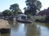
Ponder's End Lock is a paired lock
on the River Lee Navigation
in England and is located near Ponders End
, London. It is the last lock upstream that is large enough to take barges of up to 130 tons.
.
Pedestrian and cycle access by the Lea Valley Walk
Lock (water transport)
A lock is a device for raising and lowering boats between stretches of water of different levels on river and canal waterways. The distinguishing feature of a lock is a fixed chamber in which the water level can be varied; whereas in a caisson lock, a boat lift, or on a canal inclined plane, it is...
on the River Lee Navigation
River Lee Navigation
The Lee Navigation is a canalised river incorporating the River Lea . Its course runs from Hertford Castle Weir all the way to the River Thames at Bow Creek. The first lock of the navigation is Hertford Lock the last being Bow Locks....
in England and is located near Ponders End
Ponders End
Ponders End is a place in the London Borough of Enfield, North London located in an area generally known as the Lea Valley. It is roughly located in the area either side of Hertford Road between The Ride and the Boundary Public House and Wharf Road and the Southbury railway station/Kingsway...
, London. It is the last lock upstream that is large enough to take barges of up to 130 tons.
History
The lock was fully mechanised and duplicated in 1959, and was the first major work in a £864.000 British Waterways project to improve the Navigation. Work was completed in twelve months.Access to the lock
The lock is located in Wharf Road close to the crossing of the Lea Valley Road A110 and is near Ponders End railway stationPonders End railway station
Ponders End railway station is in the London Borough of Enfield in north east London at Ponders End, and is in Travelcard Zone 5, on the Tottenham Hale branch of the Lea Valley Lines, north of London Liverpool Street. The station, and all trains serving it, are operated by National Express East...
.
Pedestrian and cycle access by the Lea Valley Walk
Lea Valley Walk
The Lea Valley Walk is a long-distance path located between Leagrave, the source of the River Lea near Luton, and the Thames, at Limehouse Basin, Limehouse, east London. From its source much of the walk is rural. At Hertford the path follows the towpath of the River Lee Navigation, and it becomes...