
Oppidum d'Ensérune
Encyclopedia
The Oppidum d'Ensérune is an ancient hill-town (or oppidum
) near the village of Nissan-lez-Ensérune
, France
, located between Béziers
and Narbonne
close to the D609 (formerly RN9
) and Canal du Midi
.
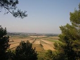
The settlement was occupied without interruption between the 6th century BC and 1st century AD , its location being chosen presumably because it was a hill with good views over the coastal plain, being close to the Roman road
Via Domitia
, the Montady lake, and fertile agricultural land below.
There is a museum on the site which offers a display of some of the finds on the site, as well as giving more information about the fort and the field system.
 Below the Oppidum was the swamp of Montady
, (centred on 43°19′12"N 3°07′24"E ), which is now wedge shaped fields separated by irrigation ditches that converge in the centre. In the 13th century, the swamp was drained; the ditches allowed water to flow to the centre of the circular depression, from which it was conveyed through underground pipes several kilometres to the south. The drainage is still functional and remains in use.
Oppidum
Oppidum is a Latin word meaning the main settlement in any administrative area of ancient Rome. The word is derived from the earlier Latin ob-pedum, "enclosed space," possibly from the Proto-Indo-European *pedóm-, "occupied space" or "footprint."Julius Caesar described the larger Celtic Iron Age...
) near the village of Nissan-lez-Ensérune
Nissan-lez-Enserune
Nissan-lez-Enserune is a commune in the Hérault department in Languedoc-Roussillon in southern France.Is situated just south of Beziers. It is twinned with Ampthill in England.-References:Based on the French Wikipedia....
, France
France
The French Republic , The French Republic , The French Republic , (commonly known as France , is a unitary semi-presidential republic in Western Europe with several overseas territories and islands located on other continents and in the Indian, Pacific, and Atlantic oceans. Metropolitan France...
, located between Béziers
Béziers
Béziers is a town in Languedoc in southern France. It is a sub-prefecture of the Hérault department. Béziers hosts the famous Feria de Béziers, centred around bullfighting, every August. A million visitors are attracted to the five-day event...
and Narbonne
Narbonne
Narbonne is a commune in southern France in the Languedoc-Roussillon region. It lies from Paris in the Aude department, of which it is a sub-prefecture. Once a prosperous port, it is now located about from the shores of the Mediterranean Sea...
close to the D609 (formerly RN9
Route nationale 9
The Route nationale 9, or RN 9, is a trunk road in France between Moulins and the frontier with Spain.-Reclassification:Much of the route of the RN 9 has now been/or in the process of being upgraded or replaced by the A75 autoroute in particular the section south of Clermont Ferrand to Béziers...
) and Canal du Midi
Canal du Midi
The is a long canal in Southern France . The canal connects the Garonne River to the on the Mediterranean and along with the Canal de Garonne forms the Canal des Deux Mers joining the Atlantic to the Mediterranean. The canal runs from the city of Toulouse down to the Étang de Thau...
.
The settlement was occupied without interruption between the 6th century BC and 1st century AD , its location being chosen presumably because it was a hill with good views over the coastal plain, being close to the Roman road
Roman road
The Roman roads were a vital part of the development of the Roman state, from about 500 BC through the expansion during the Roman Republic and the Roman Empire. Roman roads enabled the Romans to move armies and trade goods and to communicate. The Roman road system spanned more than 400,000 km...
Via Domitia
Via Domitia
The Via Domitia was the first Roman road built in Gaul, to link Italy and Hispania through Gallia Narbonensis, across what is now southern France. The route that the Romans regularised and paved was ancient when they set out to survey it, so old that it traces the mythic route travelled by Heracles...
, the Montady lake, and fertile agricultural land below.
There is a museum on the site which offers a display of some of the finds on the site, as well as giving more information about the fort and the field system.
Étang de Montady
The Étang de Montady, the "pond of Montady", is a drained "lagoon" or more accurately a former freshwater wetland that is popularly said to be "constructed by the Visigoths" but was realised by monks during the second half of the 13th century, under authorization of the archbishop of Narbonne...
, (centred on 43°19′12"N 3°07′24"E ), which is now wedge shaped fields separated by irrigation ditches that converge in the centre. In the 13th century, the swamp was drained; the ditches allowed water to flow to the centre of the circular depression, from which it was conveyed through underground pipes several kilometres to the south. The drainage is still functional and remains in use.
External links
- Ministry of Culture listing for Oppidum d'Ensérune
- Ministry of Culture photos
- http://www.oppidumdenserune.com
- http://www.flickr.com/photos/romainboussaud/2291247058/in/set-72157603980631132/ A very good Panorama of the Oppidum
- About Montady