
Mérk
Encyclopedia
Village
A village is a clustered human settlement or community, larger than a hamlet with the population ranging from a few hundred to a few thousand , Though often located in rural areas, the term urban village is also applied to certain urban neighbourhoods, such as the West Village in Manhattan, New...
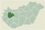
in Szabolcs-Szatmár-Bereg
Szabolcs-Szatmár-Bereg
Szabolcs-Szatmár-Bereg is an administrative county in north-eastern Hungary, bordering Slovakia, Ukraine and Romania. It shares borders with the Hungarian counties Hajdú-Bihar and Borsod-Abaúj-Zemplén...
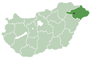
county, in the Northern Great Plain
Northern Great Plain
Northern Great Plain is a statistical region of Hungary. It is part of Great Plain and North region. Northern Great Plain includes the counties of Hajdú-Bihar, Jász-Nagykun-Szolnok, and Szabolcs-Szatmár-Bereg. It is also one of the largest plains in the world with an area of about 3000 square...
region
Region
Region is most commonly found as a term used in terrestrial and astrophysics sciences also an area, notably among the different sub-disciplines of geography, studied by regional geographers. Regions consist of subregions that contain clusters of like areas that are distinctive by their uniformity...
of eastern Hungary
Hungary
Hungary , officially the Republic of Hungary , is a landlocked country in Central Europe. It is situated in the Carpathian Basin and is bordered by Slovakia to the north, Ukraine and Romania to the east, Serbia and Croatia to the south, Slovenia to the southwest and Austria to the west. The...
.
Geography
It covers an areaArea
Area is a quantity that expresses the extent of a two-dimensional surface or shape in the plane. Area can be understood as the amount of material with a given thickness that would be necessary to fashion a model of the shape, or the amount of paint necessary to cover the surface with a single coat...
of 25.08 km² (10 sq mi) and has a population
Population
A population is all the organisms that both belong to the same group or species and live in the same geographical area. The area that is used to define a sexual population is such that inter-breeding is possible between any pair within the area and more probable than cross-breeding with individuals...
of 2328 people (2001).
The village of Mérk is situated 62 kilometers southeast of the Hungarian town Nyíregyháza. This area is part of Szabolcs-Szatmár-Bereg county located in the northeast corner of Hungary. In 2003, Mérk has 2390 inhabitants. The number of houses in the community is 750. The village is close to the border between Hungary and Romania
Romania
Romania is a country located at the crossroads of Central and Southeastern Europe, on the Lower Danube, within and outside the Carpathian arch, bordering on the Black Sea...
that crosses this area in an East to West direction at the River Kraszna. Geographically, the area constitutes a juncture of the sandy Nyírség Plain and the marshlands of Ecsed.
According to some, the name of the village was created by using the one-time very popular old Hungarian proper noun “Mérk” as a base. It is speculated that this proper noun might be rooted in the Slavic proper noun “Mirk”. According to others, however, the village was probably named after Merch, the one-time lord lieutenant of the Krauts living in the area called Szatmár.
The community is situated on the boundary between the moderately warm and moderately cold climatic zones. Its flora is primarily characterized by wattles, but one also finds oaks, woods with both soft and hard foliage, and pines. The open vegetation associations include sandy barren-meadows and tussocks, but sedges and purple marshlocks are equally present. The area is covered by meadow soils, moldy sand and marsh soils.
Approachability:
Take Road #471 (a minor road) from the turnout (exit) at Nyírbátor. The village of Mérk is connected with the two closest towns Mátészalka and Nyírbátor via bus service that runs every day. Direct train service to the village is not available; the closest train station is located in the neighbouring village of Tiborszállás.
The first written record of the village dates from 1299 when the area was owned by a person called Miklós. According to the manifestation of a charter written a year later, István (a country judge from the Ákos genus) gave the area to his daughter. In 1318 King Károly I took the area away from the Ákos genus due to their unfaithfulness to the throne. The area then got awarded to Bátori Bereck fia János who belonged to the Gut-Keled genus. From this point on, the land belonged to and thus shared its history with the castle of Ecsed. After 1613 the region became the property of the princes of Transylvania (first, Prince Bethlen, then Prince György Rákóczi). Following the death of Prince Ferenc Rákóczi II, the area became the property of Earl Aspremont through his marriage to Júlia, daughter of Prince Ferenc Rákóczi II. This was the only way to avoid the confiscation of the property from Prince Rákóczi II’s family. In 1724 Sándor Károlyi bought the area from the Aspremont family. Károlyi settled Krauts in the area. From this point on, the region was part of the manor of the Károlyi family until 1945.
Following the turn of the 19th and 20th century, the village that was settled by Krauts in the 18th century continued to strongly preserve its cultural insularity. However, the assimilation of the population to the environmental cultures has already started with great intensity.
Due to the regulations pertaining new country borders between Hungary and Romania that were included in the Treaty of Trianon (June 4, 1920), the villages in this area that were inhabited by the Krauts were ordered to belong to Romania. From this point on, the village of Mérk is more connected to the Hungarian towns of Mátészalka and Nyírbátor that are approximately 20 km (12 mi) away. From 1920, the Kraut culture started to fade away in the villages (e.g. Csanálos, Fény, Börvely) in this area since the communities now belonged to Romania and thus to the Romanian culture. The relative unity of the villages that were inhabited by the Krauts ceased to exist.
During WWI 26 people from the village of Mérk died in action. Following WWII, some 300 people from the village were deported for “malenkij robot” to the Soviet Union due to their Kraut cultural heritage. During this period, many people requested officially to change their Kraut/German names to Hungarian ones.
In 1960 the forced creation of the farmer’s cooperative was uneventful in this area, primarily because the sorely tried population did not want to be tried again.
In 1990, the village of Mérk was listed by Hungarian public administrators as a village with an independent mayor and an independent representative body.
Legend
According to the almost forgotten legend, as Prince Gábor Báthori was mustering up his army against the Turks, a frightening dragon appeared and tried to hinder the army’s procession. Somebody had to cross swords with the beast in order to avoid being delayed. The Prince was asked whether he dares taking the beast on. The answer was yes. At the location where the Prince uttered the word “yes”, the village called “Mérk” sprang up years later. (The word ‘merek’ in Hungarian means “I dare”.) The story runs mentioning that first it was the shoulder of the dragon that the Prince wounded. At the location where the wounding of the beast took place, the village “Vállaj” got created. (The word “Vállaj” means the lower portion of a shoulder.) When the Prince defeated the beast, he threw its lifeless body into a place where nettles were growing. Later, the village “Csanálos” (old Hungarian word referring to a place where nettles grow) got created at the location.Coat of arms of Mérk
The coat of arms of the village of Mérk depicts the moment when the valiant is getting ready to kill the dragon as a test of his courage.
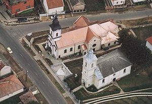
Art relics and tourist attractions in the village
- The Roman Catholic Church was erected in 1882-84 in honour of St. Peter and St. Paul (eclectic)
- The Protestant Church was erected between 1899 and 1914 (eclectic)
- The memorial that was erected in honor of the people died in WWII; it is located in the space between the two churches
- The tawdry barns (Kraut folklore buildings)
- A collection of hunter József Janovszky’s trophy collection.
Several people have businesses related to traditional (folklore) activities including net spinning, homespun production (by hand), frail and pad production, embroidery and written embroidery production.
The village also has a population of Hungarian Romani (Gypsy) people. Several Romani families have businesses related to Romani folklore music (both instrumental music and singing).
The village is close to the River Kraszna where flyfishing opportunities are available. One of the major fishes in the area is the pike.