

Montaña de Oro State Park
Encyclopedia
Montaña de Oro is a state park
in California
, United States
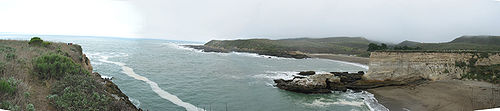
. The park is located six miles southwest of Morro Bay and 2 miles south of Los Osos. The name "Mountain of Gold" comes from the golden wildflowers found in the park.
It has 8,000 acres (32 km²) of cliffs, sandy beaches, coastal plains, streams, canyons, and hills, including the 1,347 ft (411 m) Valencia Peak. The park has many hiking, mountain biking, and equestrian trails, as well as a campground located across from Spooner’s Cove, a popular beach.
as part of a deficit reduction program but will now stay open due to public outcry.
In 1769, Don Gaspar de Portola marched his troops north from San Diego to establish new territory for the king of Spain. With the beginning of the Mission period, the Indians were moved inland, and this was the beginning of the end for the Chumash. Most died from European diseases to which they had no immunity. The survivors abandoned their villages and disappeared. With them, their customs, heritage and culture all but vanished as well. Traces of Chumash middens (refuse mounds) and village sites can still be seen in the park, but our knowledge of the Chumash culture remains sketchy. Archaeological advances and further research may help fill in the gaps. For this reason, and so that others may enjoy them, it is against the law to tamper with or disturb any Indian sites.
 The property rights for the Montana de Oro State Park land area changed hands several times after California became a territory of the United States. It was used mostly for grazing sheep until 1892, when Alden B. Spooner, Jr., leased the land he later purchased around Islay Creek. He brought in dairy cattle, hogs and other agriculture. His two sons founded the Pecho Ranch & Stock Co., and built a ranch house, a complex of barns, a creamery, stables, sheds, and a waterwheel for power. On the south bluff of Spooner's Cove they utilized a warehouse with a long chute that led down to a wharf and a loading boom to service coastal steamers. The land just to the north was owned by Alexander S. Hazard, who also raised crops and maintained a dairy. Hoping to cash in on California's growing need for timber, he planted hundreds of eucalyptus trees, turning Hazard Canyon into a prospective lumber farm. Unfortunately, eucalyptus proved unsatisfactory for commercial use. In the early 1940s, a flood scoured Hazard Canyon, and in 1947 a grass fire burned up the coast from Diablo Canyon, destroying much of what had been the Hazard dairy buildings. However, Hazard's legacy, the rows of eucalyptus trees, remains. Rancher Oliver C. Field bought the land in the early 1940s, but sold it to Irene McAllister about ten years later. In 1965 the property was purchased by the State of California for a state park, and it was decided to keep the name McAllister had given it "Montana de Oro".
On April 24, 1965, Rancho Montana de Oro was dedicated as a California State Park after it was acquired in a "friendly" eminent domain proceeding under the Park acquisition program that then Governor Edmund G. "Pat" Brown had launched and managed to fund.
The Rancho Montana de Oro property was held by a corporation, Rancho Montana de Oro, Inc., which was owned by the prominent Los Angeles trial and constitutional lawyer Morris Lavine and Irene M. Starkey. They had the options of developing the park land or preserving it as open space and in the public trust. They chose the later despite the fact that their financial gains were far less by doing so.
Rancho Montana de Oro, until recently, has had the longest uninterrupted, preserved and undeveloped coastal area of any publicly owned land in California.
and Point Buchon State Marine Reserve and Marine Conservation Area are marine protected areas offshore from the Morro Bay area. Like underwater parks, these marine protected areas help conserve ocean wildlife and marine ecosystems.
State park
State parks are parks or other protected areas managed at the federated state level within those nations which use "state" as a political subdivision. State parks are typically established by a state to preserve a location on account of its natural beauty, historic interest, or recreational...
in California
California
California is a state located on the West Coast of the United States. It is by far the most populous U.S. state, and the third-largest by land area...
, United States
United States
The United States of America is a federal constitutional republic comprising fifty states and a federal district...
. The park is located six miles southwest of Morro Bay and 2 miles south of Los Osos. The name "Mountain of Gold" comes from the golden wildflowers found in the park.
It has 8,000 acres (32 km²) of cliffs, sandy beaches, coastal plains, streams, canyons, and hills, including the 1,347 ft (411 m) Valencia Peak. The park has many hiking, mountain biking, and equestrian trails, as well as a campground located across from Spooner’s Cove, a popular beach.
Proposed for closure
Los Osos Oaks State Reserve was one of the 48 California state parks proposed for closure in January 2008 by California's Governor Arnold SchwarzeneggerArnold Schwarzenegger
Arnold Alois Schwarzenegger is an Austrian-American former professional bodybuilder, actor, businessman, investor, and politician. Schwarzenegger served as the 38th Governor of California from 2003 until 2011....
as part of a deficit reduction program but will now stay open due to public outcry.
Background
Five hundred years ago, when Europeans first arrived on the California's central coast, they found it inhabited by the Chumash Indians. An estimated 20,000 to 30,000 of them lived in small villages spread over a territory which extended from Morro Bay south to Malibu. Although the Chumash depended heavily upon the sea, they also drew on many other sources for food, clothing, and shelter, and were probably part of a large trading network. The Spanish Explorers who visited the Montana de Oro area in 1542 recorded that the Indians were attractive, friendly people who paddled out to greet them in canoes.In 1769, Don Gaspar de Portola marched his troops north from San Diego to establish new territory for the king of Spain. With the beginning of the Mission period, the Indians were moved inland, and this was the beginning of the end for the Chumash. Most died from European diseases to which they had no immunity. The survivors abandoned their villages and disappeared. With them, their customs, heritage and culture all but vanished as well. Traces of Chumash middens (refuse mounds) and village sites can still be seen in the park, but our knowledge of the Chumash culture remains sketchy. Archaeological advances and further research may help fill in the gaps. For this reason, and so that others may enjoy them, it is against the law to tamper with or disturb any Indian sites.
Recent history
On April 24, 1965, Rancho Montana de Oro was dedicated as a California State Park after it was acquired in a "friendly" eminent domain proceeding under the Park acquisition program that then Governor Edmund G. "Pat" Brown had launched and managed to fund.
The Rancho Montana de Oro property was held by a corporation, Rancho Montana de Oro, Inc., which was owned by the prominent Los Angeles trial and constitutional lawyer Morris Lavine and Irene M. Starkey. They had the options of developing the park land or preserving it as open space and in the public trust. They chose the later despite the fact that their financial gains were far less by doing so.
Rancho Montana de Oro, until recently, has had the longest uninterrupted, preserved and undeveloped coastal area of any publicly owned land in California.
Marine Protected Areas
Morro Bay State Marine Recreational Management Area and Morro Bay State Marine ReserveMorro Bay State Marine Recreational Management Area and Morro Bay State Marine Reserve
Morro Bay State Marine Recreational Management Area and Morro Bay State Marine Reserve are two marine protected areas that provide protection for Morro Bay Estuary on California’s central coast. The two marine protected areas together encompass...
and Point Buchon State Marine Reserve and Marine Conservation Area are marine protected areas offshore from the Morro Bay area. Like underwater parks, these marine protected areas help conserve ocean wildlife and marine ecosystems.