

List of bridges on the National Register of Historic Places in Texas
Encyclopedia
This is a list of bridge
s currently on the National Register of Historic Places
in the U.S. state
of Texas
.
Bridge
A bridge is a structure built to span physical obstacles such as a body of water, valley, or road, for the purpose of providing passage over the obstacle...
s currently on the National Register of Historic Places
National Register of Historic Places
The National Register of Historic Places is the United States government's official list of districts, sites, buildings, structures, and objects deemed worthy of preservation...
in the U.S. state
U.S. state
A U.S. state is any one of the 50 federated states of the United States of America that share sovereignty with the federal government. Because of this shared sovereignty, an American is a citizen both of the federal entity and of his or her state of domicile. Four states use the official title of...
of Texas
Texas
Texas is the second largest U.S. state by both area and population, and the largest state by area in the contiguous United States.The name, based on the Caddo word "Tejas" meaning "friends" or "allies", was applied by the Spanish to the Caddo themselves and to the region of their settlement in...
.
| Name | Image | Built | Listed | Location | County | Type |
|---|---|---|---|---|---|---|
| Almeda Road Bridge over Brays Bayou | 1931 | 2007-11-29 | Houston Houston, Texas Houston is the fourth-largest city in the United States, and the largest city in the state of Texas. According to the 2010 U.S. Census, the city had a population of 2.1 million people within an area of . Houston is the seat of Harris County and the economic center of , which is the ... 29°42′47.5"N 95°22′55.5"W |
Harris Harris County, Texas As of the 2010 Census, the population of the county was 4,092,459, White Americans made up 56.6% of Harris County's population; non-Hispanic whites represented 33.0% of the population. Black Americans made up 18.9% of the population. Native Americans made up 0.7% of Harris County's population... |
Continuous span concrete beam Beam bridge Beam bridges are the most simple of structural forms being supported by an abutment at each end of the deck. No moments are transferred through the support hence their structural type is known as simply supported.... |
|
| Angelina River Bridge Angelina River Bridge Angelina River Bridge is a historic bridge on US 59 over Angelina River in Lufkin, Texas.It was built in 1935 and added to the National Register of Historic Places in 1988.... |
1935 | 1988-12-22 | Lufkin Lufkin, Texas Lufkin is a city in Angelina County, Texas, United States. Founded in 1882, the population was 35,067 in 2010. It is the county seat of Angelina County, and is situated in Deep East Texas.-History:... 31°27′25"N 94°43′34"W |
Angelina Angelina County, Texas Angelina County is a county located in the U.S. state of Texas. Angelina County was formed in 1846 from Nacogdoches County. As of 2000, the population was 80,130. Its county seat is Lufkin. Angelina is named for a Hainai Native American woman who assisted early Spanish missionaries and was named... |
Span concrete beam | |
| Beaver Creek Bridge Beaver Creek Bridge (Electra, Texas) Beaver Creek Bridge, also known as FM 2326 Bridge at Beaver Creek or WC2215-02-002, is a historic bridge built in 1925 in Texas. It was listed on the National Register of Historic Places in 1996.... |
1925 | 1996-10-10 | Electra Electra, Texas Electra is a city in Wichita County, Texas, United States. It is part of the Wichita Falls, Texas Metropolitan Statistical Area. The United States Census Bureau counted Electra's population as 3,168 at the 2000 census and estimated it to be 2,891 as of 2006... 33°54′21"N 98°54′17"W |
Wichita Wichita County, Texas As of the census of 2000, there were 131,664 people, 48,441 households, and 32,891 families residing in the county. The population density was 210 people per square mile . There were 53,304 housing units at an average density of 85 per square mile... |
Warren pony truss | |
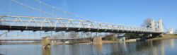
| Bluff Dale Suspension Bridge Bluff Dale Suspension Bridge The Bluff Dale Suspension Bridge is a historic bridge located near Bluff Dale, Texas, United States. The bridge was built in 1891 and the spans 225 feet across the Paluxy River... |
 |
1977-12-20 | Bluff Dale Bluff Dale, Texas Bluff Dale is an unincorporated community in Erath County, Texas, United States.The Bluff Dale Independent School District serves area students.- History :BLUFF DALE, Texas is on U.S. Highway 377 and the North Paluxy River in northeastern Erath County... 32°21′15"N 98°1′32"W |
Erath Erath County, Texas Erath County is a county located on the Edwards Plateau in the U.S. state of Texas. In 2000, its population was 33,001. It is named for George Bernard Erath, an early surveyor and a soldier at the Battle of San Jacinto. The seat of the county is Stephenville.... |
Cable-stayed | |
| Brazoria Bridge | 1939 | 1991-06-14 | Brazoria Brazoria, Texas Brazoria is a city of Brazoria County in the U.S. state of Texas within the metropolitan area. As of the 2000 U.S. Census, the city population was 2,787.Brazoria was originally founded as a port for Stephen F... 29°3′15"N 95°33′25"W |
Brazoria Brazoria County, Texas Brazoria County[p] is a county in the U.S. state of Texas, located on the Gulf Coast within the Houston–Sugar Land–Baytown metropolitan area. Regionally, parts of the county are within the extreme southern-most fringe of the regions locally known as Southeast Texas. Brazoria County is among a... |
Parker through truss | |
| Bunton Branch Bridge | 1915, 1917, 1932 | 2002-02-19 | Kyle Kyle, Texas Kyle is a town in Hays County, Texas, United States. The population was 5,314 at the 2000 census; it was 26,103 in the 2008 census estimate, making Kyle one of the fastest growing cities in Texas.-Geography:... 30°1′5"N 97°51′31.5"W |
Hays Hays County, Texas Hays County is a county located on the Edwards Plateau in the U.S. state of Texas. In 2010, its official population had reached 157,107. It is named for John Coffee Hays, a Texas Ranger and Mexican-American War officer. The seat of the county is San Marcos.... |
Concrete arch Arch bridge An arch bridge is a bridge with abutments at each end shaped as a curved arch. Arch bridges work by transferring the weight of the bridge and its loads partially into a horizontal thrust restrained by the abutments at either side... |
|
| Burr's Ferry Bridge Burr's Ferry Bridge Burr's Ferry Bridge is a bridge on the Sabine River where LA 8 meets Texas State Highway 63 at the Louisiana and Texas state lines.-External links:* *... |
1936, 1937 | 1998-05-18 | Burkeville Burkeville, Texas Burkeville is an unincorporated town in northern Newton County, Texas, United States. It sits at the intersection of State Highways 63 and 87 10 miles west of the Sabine River. The Burkeville Independent School District serves the resident students.... 31°3′50"N 93°31′13"W |
Newton Newton County, Texas Newton County is the easternmost county in the U.S. state of Texas. In of 2000, its population was 15,072. Its county seat is Newton. Newton county is named for John Newton, a veteran of the American Revolutionary War... |
Parker through truss | |
| Colorado River Bridge | 1930 | 1993-03-18 | Wharton Wharton, Texas Wharton is a city in Wharton County, Texas, United States. The population was 9,237 at the 2000 census. It is the county seat of Wharton County and is located on the Colorado River of Texas just south of U.S... 29°18′30"N 96°6′13"W |
Wharton | Parker though truss | |
| Colorado River Bridge at Bastrop | 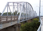 |
1923 | 1990-07-19 | Bastrop Bastrop, Texas -Demographics:As of the census of 2000, there are 5340 people in Bastrop, organized into 2034 households and 1336 families. The population density is 734.8 people per square mile . There are 2,239 housing units at an average density of 308.1 per square mile... 30°6′35.25"N 97°19′21.75"W |
Bastrop Bastrop County, Texas Bastrop County is a county located in the U.S. state of Texas. As of 2006, the population was 71,700. Its county seat is Bastrop. Bastrop County is named for Felipe Enrique Neri, Baron de Bastrop , an early Dutch settler who assisted Stephen F... |
Parker through truss |
| Cow Bayou Swing Bridge | 1940 | 2010-5-10 | Bridge City Bridge City, Texas Bridge City is a city in Orange County, Texas, United States. The population was 8,651 at the 2000 census. The town borders the Neches River and Cow Bayou. It is part of the Beaumont–Port Arthur Metropolitan Statistical Area.... 30.0448363°N 93.8213807°W |
Orange Orange County, Texas Orange County is one of 254 counties of the State of Texas and its county seat is the city of Orange, Texas. In the year 2000, the population of Orange County was about 85,000. Orange County is the county in the very southeastern corner of Texas, with a boundary with Louisiana and a seacoast on the... |
||
| Cummins Creek Bridge | 1890 | 1975-04-21 | Round Top Round Top, Texas Round Top is a town in Fayette County, Texas, United States. The population was 77 at the 2000 census.Round Top is the home of three visitor-drawing programs:... 30°4′7"N 96°43′9"W |
Fayette Fayette County, Texas Fayette County is a county located in the U.S. state of Texas. As of 2000, the population was 21,804. Its county seat is La Grange. Fayette is named for the Marquis de la Fayette, a French nobleman who became an American Revolutionary War hero... |
Pratt through truss | |
| Deweyville Swing Bridge | 2011-06-08 | Deweyville Deweyville, Texas Deweyville is a census-designated place in Newton County, Texas, United States. The population was 1,190 at the 2000 census.-Geography:Deweyville is located at .... |
Newton Newton County, Texas Newton County is the easternmost county in the U.S. state of Texas. In of 2000, its population was 15,072. Its county seat is Newton. Newton county is named for John Newton, a veteran of the American Revolutionary War... |
|||
| Dionicio Rodriguez Bridge in Brackenridge Park | 2004-10-22 | San Antonio San Antonio, Texas San Antonio is the seventh-largest city in the United States of America and the second-largest city within the state of Texas, with a population of 1.33 million. Located in the American Southwest and the south–central part of Texas, the city serves as the seat of Bexar County. In 2011,... 29°27′53.5"N 98°28′7"W |
Bexar Bexar County, Texas As of the census of 2000, there were 1,392,931 people, 488,942 households, and 345,681 families residing in the county. The population density was 1,117 people per square mile . There were 521,359 housing units at an average density of 418 per square mile... |
Faux Bois Faux Bois Faux bois refers to the artistic imitation of wood or wood grains in various media. The craft has roots in the Renaissance with trompe-l'œil. It was probably first crafted with concrete using a steel armature by the inventor of ferrocement, Joseph Monier. In 1875, Monier created the first bridge... sculpture |
||
| Faust Street Bridge | 2009-3-17 | New Braunfels New Braunfels, Texas New Braunfels is a city in Comal and Guadalupe counties in the U.S. state of Texas that is a principal city of the metropolitan area. Braunfels means "brown rock" in German; the city is named for Braunfels, in Germany. The city's population was 57,740 as of the 2010 census, up 58% from the 2000... 29°41′48"N 98°6′25"W |
Comal Comal County, Texas Comal County is a county located on the Edwards Plateau in the U.S. state of Texas. In 2010, its population was 108,472. Its seat is New Braunfels.Comal County is part of the San Antonio Metropolitan Statistical Area.-History Timeline:... |
|||
| Fort Griffin Brazos River Bridge | 1885 | 1979-10-16 | Fort Griffin 32°56′5"N 99°13′26"W |
Shackelford Shackelford County, Texas As of the census of 2000, there were 3,302 people, 1,300 households, and 941 families residing in the county. The population density was 4 people per square mile . There were 1,613 housing units at an average density of 2 per square mile... |
Pratt through truss | |
| Galveston Causeway Galveston Causeway The Galveston Causeway is a set of causeways in Galveston, Texas, United States. Two of the routes carry the southbound and northbound traffic of Interstate 45, while the original causeway is restricted to rail traffic. It is the only free roadway access point to Galveston Island. The causeway... |
1912, 1922 | 1976-12-12 | Galveston Galveston, Texas Galveston is a coastal city located on Galveston Island in the U.S. state of Texas. , the city had a total population of 47,743 within an area of... 29°17′51"N 94°53′12"W |
Galveston Galveston County, Texas Galveston County is a county located in the U.S. state of Texas within the Houston–Sugar Land–Baytown metropolitan area. As of the 2010 U.S. Census, the population was 291,309. Its county seat is Galveston. League City is the largest city in Galveston County in terms of population; between... |
Concrete arch | |
| Gregory Road Bridge at Duck Creek | 1923 | 2004-01-14 | Sanger Sanger, Texas Sanger is a city in Denton County, Texas, United States. The population was 4,534 at the 2000 census. The 2006 population was 6,200. -Geography:Sanger is located at .... 33°25′29"N 97°13′59"W |
Denton Denton County, Texas Denton County is a county located in the U.S. state of Texas. In 2000, its population was 432,976; in 2009 the estimated population had reached 628,300. Part of the Dallas – Fort Worth Metroplex, it is one of the fastest-growing counties in the United States. The county seat is Denton. The county... |
Warren pony truss | |
| Hill Street Bridge over Buffalo Bayou | 1938 | 2007-10-31 | Houston Houston, Texas Houston is the fourth-largest city in the United States, and the largest city in the state of Texas. According to the 2010 U.S. Census, the city had a population of 2.1 million people within an area of . Houston is the seat of Harris County and the economic center of , which is the ... 29°45′40"N 95°20′36"W |
Harris Harris County, Texas As of the 2010 Census, the population of the county was 4,092,459, White Americans made up 56.6% of Harris County's population; non-Hispanic whites represented 33.0% of the population. Black Americans made up 18.9% of the population. Native Americans made up 0.7% of Harris County's population... |
Steel beam | |
| Houston Street Viaduct | 1910, 1911 | 1984-08-09 | Dallas Dallas, Texas Dallas is the third-largest city in Texas and the ninth-largest in the United States. The Dallas-Fort Worth Metroplex is the largest metropolitan area in the South and fourth-largest metropolitan area in the United States... 32°46′12"N 96°48′31"W |
Dallas Dallas County, Texas As of the census of 2000, there were 2,218,899 people, 807,621 households, and 533,837 families residing in the county. The population density was 2,523 people per square mile . There were 854,119 housing units at an average density of 971/sq mi... |
Continuous span concrete arch | |
| Hubbard Creek Bridge | 1928, 1929 | 1996-10-10 | Albany Albany, Texas Albany is a city in Shackelford County, Texas, United States. The population was 2,034 at the 2010 Census. It is the county seat of Shackelford County.-History:... 32°41′25"N 99°9′53"W |
Shackelford Shackelford County, Texas As of the census of 2000, there were 3,302 people, 1,300 households, and 941 families residing in the county. The population density was 4 people per square mile . There were 1,613 housing units at an average density of 2 per square mile... |
Pratt through truss | |
| Iron Bridge | 1883 | 1978-12-22 | Bastrop Bastrop, Texas -Demographics:As of the census of 2000, there are 5340 people in Bastrop, organized into 2034 households and 1336 families. The population density is 734.8 people per square mile . There are 2,239 housing units at an average density of 308.1 per square mile... 30.1314165°N 97.3210211°W |
Bastrop Bastrop County, Texas Bastrop County is a county located in the U.S. state of Texas. As of 2006, the population was 71,700. Its county seat is Bastrop. Bastrop County is named for Felipe Enrique Neri, Baron de Bastrop , an early Dutch settler who assisted Stephen F... |
Truss Type | |
| Lamar Boulevard Bridge Lamar Boulevard Bridge The Lamar Boulevard Bridge is a historic bridge carrying Lamar Boulevard over Lady Bird Lake in downtown Austin, Texas, United States. The bridge features six open spandrel concrete arches and carries thousands of vehicles daily across the river... |
 |
1941, 1942 | 1994-07-07 | Austin Austin, Texas Austin is the capital city of the U.S. state of :Texas and the seat of Travis County. Located in Central Texas on the eastern edge of the American Southwest, it is the fourth-largest city in Texas and the 14th most populous city in the United States. It was the third-fastest-growing large city in... 30°15′56.5"N 97°45′24"W |
Travis Travis County, Texas As of 2009, the U.S. census estimates there were 1,026,158 people, 320,766 households, and 183,798 families residing in the county. The population density was 821 people per square mile . There were 335,881 housing units at an average density of 340 per square mile... |
Continuous span concrete arch |
| Lone Wolf Crossing Bridge | 1922 | 1988-11-25 | San Angelo San Angelo, Texas San Angelo is a city in the state of Texas. Located in West Central Texas it is the county seat of Tom Green County. As of 2010 according to the United States Census Bureau, the city had a total population of 93,200... 31°26′45"N 100°25′30"W |
Tom Green | Pratt through truss | |
| McKee Street Bridge | 1932 | 2002-09-03 | Houston Houston, Texas Houston is the fourth-largest city in the United States, and the largest city in the state of Texas. According to the 2010 U.S. Census, the city had a population of 2.1 million people within an area of . Houston is the seat of Harris County and the economic center of , which is the ... 29°45′57"N 95°21′7"W |
Harris Harris County, Texas As of the 2010 Census, the population of the county was 4,092,459, White Americans made up 56.6% of Harris County's population; non-Hispanic whites represented 33.0% of the population. Black Americans made up 18.9% of the population. Native Americans made up 0.7% of Harris County's population... |
Continuous span concrete beam | |
| Medio Creek Bridge | 1897, 1923 | 1988-10-13 | Normanna Normanna, Texas Normanna is a census-designated place in Bee County, Texas, United States. The population was 121 at the 2000 census.-Geography:Normanna is located at .... 28°31′46"N 97°47′38"W |
Bee Bee County, Texas Bee County is a county located in the U.S. state of Texas. Bee County was founded December 8, 1857. As of 2010, the population was 31,861. Its county seat is Beeville. Bee County is named for Barnard E... |
Pratt through truss | |
| Missouri, Kansas & Texas Railroad Bridge at the Leon River | 1990-12-26 | Belton Belton, Texas Belton is a city in Bell County, Texas, United States. The population was 14,623 at the 2000 census. It is the county seat of Bell County.Belton is part of the Killeen – Temple – Fort Hood metropolitan area.-Geography:... 31°3′44"N 97°26′35"W |
Bell Bell County, Texas Bell County is a county located in the U.S. state of Texas. Bell County was founded in 1850. It is part of the Killeen–Temple–Fort Hood Metropolitan Statistical Area. In 2000, the county's population was 237,974; in 2010 the U.S. Census Bureau reported that its population had reached... |
Parker through truss | ||
| Montopolis Bridge Montopolis Bridge The Montopolis Bridge is a historic Parker through truss bridge in Austin, Texas. It is located in the neighborhood of Montopolis where the southbound frontage road of U.S. Route 183 crosses the Colorado River in southeastern Travis County... |
1937, 1938 | 1996-10-10 | Austin Austin, Texas Austin is the capital city of the U.S. state of :Texas and the seat of Travis County. Located in Central Texas on the eastern edge of the American Southwest, it is the fourth-largest city in Texas and the 14th most populous city in the United States. It was the third-fastest-growing large city in... 30°14′43"N 97°41′28"W |
Travis Travis County, Texas As of 2009, the U.S. census estimates there were 1,026,158 people, 320,766 households, and 183,798 families residing in the county. The population density was 821 people per square mile . There were 335,881 housing units at an average density of 340 per square mile... |
Parker through truss | |
| Mueller Bridge | 1915 | 2007-10-16 | La Vernia La Vernia, Texas La Vernia is a city in Wilson County, Texas, United States. The population was 931 at the 2000 census. It is part of the San Antonio Metropolitan Statistical Area.-History:... 29°21′5"N 98°4′28"W |
Wilson Wilson County, Texas Wilson County is a county located in the U.S. state of Texas. In 2000, its population was 32,408. Its county seat is Floresville. The county is named after James Charles Wilson.... |
Warren polygonal chord truss | |
| Mulberry Creek Bridge | 1888 | 1975-04-21 | Schulenburg Schulenburg, Texas Schulenburg is a city in Fayette County, Texas, United States. The population was 2,699 at the 2000 census.Known for its German culture, Schulenburg is home of the Texas Polka Music Museum.-Geography:Schulenburg is located at .... 29°40′27"N 96°54′39"W |
Fayette Fayette County, Texas Fayette County is a county located in the U.S. state of Texas. As of 2000, the population was 21,804. Its county seat is La Grange. Fayette is named for the Marquis de la Fayette, a French nobleman who became an American Revolutionary War hero... |
Pratt pony truss | |
| Old Alton Bridge Old Alton Bridge Old Alton Bridge is a historic iron through-truss bridge connecting the cities of Denton, Texas and Copper Canyon, Texas. Built in 1884 by the King Iron Bridge Manufacturing Company, it originally carried horses and later automobiles over Hickory Creek at a location that once was a popular ford for... |
 |
1884 | 1988-07-08 | Copper Canyon Copper Canyon, Texas Copper Canyon is a town in Denton County, Texas, United States. Copper Canyon was founded in April 1973. Residents decided to incorporate the town in an effort to preserve the rural atmosphere of the community. The first mayor was Robert Woodin. Council meetings were held in homes until 1978, when... 33°7′45"N 97°6′13"W |
Denton Denton County, Texas Denton County is a county located in the U.S. state of Texas. In 2000, its population was 432,976; in 2009 the estimated population had reached 628,300. Part of the Dallas – Fort Worth Metroplex, it is one of the fastest-growing counties in the United States. The county seat is Denton. The county... |
Pratt through truss bridge |
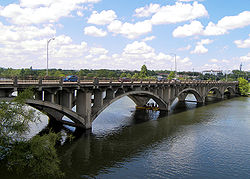
| Paddock Viaduct | 1912, 1914 | 1976-03-15 | Fort Worth Fort Worth, Texas Fort Worth is the 16th-largest city in the United States of America and the fifth-largest city in the state of Texas. Located in North Central Texas, just southeast of the Texas Panhandle, the city is a cultural gateway into the American West and covers nearly in Tarrant, Parker, Denton, and... 32°45′36"N 97°20′5"W |
Tarrant Tarrant County, Texas Tarrant County is a county located in the U.S. state of Texas. As of the 2010 U.S. Census, it had a population of 1,809,034. Its county seat is Fort Worth. Tarrant County is the sixteenth most populous county in the United States and the third most populous in Texas. The county is named in honor... |
Continuous span concrete arch | |
| Port Arthur-Orange Bridge | 1936, 1938 | 1996-10-10 | Groves Groves, Texas Groves is a city in Jefferson County, Texas, United States. The population was 15,733 at the 2000 census. A July 1, 2008 U.S. Census Bureau estimate placed the population at 14,393. It is part of the Beaumont–Port Arthur Metropolitan Statistical Area.... 29°58′11"N 93°52′24"W |
Jefferson Jefferson County, Texas Jefferson County is a county located in the state of Texas, United States. As of 2000, the population was 252,051. Its county seat is Beaumont, and it is named for the former U.S... |
Cantilever through truss Cantilever bridge A cantilever bridge is a bridge built using cantilevers, structures that project horizontally into space, supported on only one end. For small footbridges, the cantilevers may be simple beams; however, large cantilever bridges designed to handle road or rail traffic use trusses built from... |
|
| Rector Road Bridge at Clear Creek | 1907, 1908 | 2004-01-14 | Sanger Sanger, Texas Sanger is a city in Denton County, Texas, United States. The population was 4,534 at the 2000 census. The 2006 population was 6,200. -Geography:Sanger is located at .... 33°19′50"N 97°8′56"W |
Denton Denton County, Texas Denton County is a county located in the U.S. state of Texas. In 2000, its population was 432,976; in 2009 the estimated population had reached 628,300. Part of the Dallas – Fort Worth Metroplex, it is one of the fastest-growing counties in the United States. The county seat is Denton. The county... |
Pratt through truss | |
| Regency Suspension Bridge Regency Bridge The Regency Bridge, locally known as the "Swinging Bridge," is a one-lane suspension bridge over the Colorado River in Texas. It is located at the intersection of Mills County Road 433 and San Saba County Road 137, both gravel roads, near a small community called Regency. The bridge saddles Mills... |
1939 | 1976-12-12 | Regency 31°24′37"N 98°50′45"W |
Mills Mills County, Texas Mills County is a county located on the Edwards Plateau in Central Texas. In 2000, its population was 5,151. Mills County is named for John T. Mills, a justice of the Texas Supreme Court... |
Suspension Suspension bridge A suspension bridge is a type of bridge in which the deck is hung below suspension cables on vertical suspenders. Outside Tibet and Bhutan, where the first examples of this type of bridge were built in the 15th century, this type of bridge dates from the early 19th century... |
|
| Riverside Swinging Bridge | 1904 | 1979-09-12 | Riverside Riverside, Texas Riverside is a small city in Walker County, Texas, United States. The population was 425 at the 2000 census. Two famous natives of Riverside are singer-actress Jennifer Holliday , best known for her creation of the role of Effie in the successful Tony-award winning Broadway musical... 30°51′26"N 95°23′46"W |
Trinity, Walker Walker County, Texas Walker County is a county located in the U.S. state of Texas. In 2010, its population was 67,861. Its county seat is Huntsville.Initially, Walker County was named for Robert J. Walker, a legislator from Mississippi who introduced into the United States Congress the resolution to annex Texas... |
Pratt through truss | |
| Roma-San Pedro International Bridge | 1927, 1928 | 1984-03-23 | Roma-Los Saenz 26°24′13"N 99°1′6"W |
Starr Starr County, Texas Starr County is a county located in the U.S. state of Texas. In 2010, its population was 60,968. Its county seat is Rio Grande City. The county is named for James Harper Starr, who served as Secretary of the Treasury of the Republic of Texas. It is part of the Rio Grande City-Roma, TX,... |
Suspension | |
| Route 66 Bridge over the Chicago, Rock Island and Gulf Railroad | 1932 | 2007-04-03 | Shamrock Shamrock, Texas -Demographics:As of the census of 2000, there were 2,029 people, 852 households, and 550 families residing in the city. The population density was 979.7 people per square mile . There were 1,072 housing units at an average density of 517.6 per square mile... 35°13′35"N 100°6′20"W |
Wheeler | ||
| Sabine Street Bridge over Buffalo Bayou | 1924 | 2007-09-28 | Houston Houston, Texas Houston is the fourth-largest city in the United States, and the largest city in the state of Texas. According to the 2010 U.S. Census, the city had a population of 2.1 million people within an area of . Houston is the seat of Harris County and the economic center of , which is the ... 29°45′40.75"N 95°22′31.5"W |
Harris Harris County, Texas As of the 2010 Census, the population of the county was 4,092,459, White Americans made up 56.6% of Harris County's population; non-Hispanic whites represented 33.0% of the population. Black Americans made up 18.9% of the population. Native Americans made up 0.7% of Harris County's population... |
Concrete span | |
| San Jacinto Street Bridge over Buffalo Bayou | 1914 | 2007-10-16 | Houston Houston, Texas Houston is the fourth-largest city in the United States, and the largest city in the state of Texas. According to the 2010 U.S. Census, the city had a population of 2.1 million people within an area of . Houston is the seat of Harris County and the economic center of , which is the ... 29°45′47.75"N 95°21′27"W |
Harris Harris County, Texas As of the 2010 Census, the population of the county was 4,092,459, White Americans made up 56.6% of Harris County's population; non-Hispanic whites represented 33.0% of the population. Black Americans made up 18.9% of the population. Native Americans made up 0.7% of Harris County's population... |
Concrete arch | |
| State Highway 16 Bridge at the Brazos River | 1938, 1939 | 1996-10-10 | Benjamin Benjamin, Texas Benjamin is a city in Knox County, Texas, United States. It is the county seat of Knox County. The population was 258 at the 2010 census.-Geography:Benjamin is located at . It is situated at the junction of U.S... 33°30′0"N 99°48′5"W |
Knox Knox County, Texas As of the census of 2000, there were 4,253 people, 1,690 households, and 1,166 families residing in the county. The population density was 5 people per square mile . There were 2,129 housing units at an average density of 2 per square mile... |
Warren through truss | |
| State Highway 19 Bridge at Trinity River | 1940 | 2004-12-01 | Riverside Riverside, Texas Riverside is a small city in Walker County, Texas, United States. The population was 425 at the 2000 census. Two famous natives of Riverside are singer-actress Jennifer Holliday , best known for her creation of the role of Effie in the successful Tony-award winning Broadway musical... 30°51′35"N 95°23′55"W |
Trinity, Walker Walker County, Texas Walker County is a county located in the U.S. state of Texas. In 2010, its population was 67,861. Its county seat is Huntsville.Initially, Walker County was named for Robert J. Walker, a legislator from Mississippi who introduced into the United States Congress the resolution to annex Texas... |
Parker through truss | |
| State Highway 23 Bridge at the Clear Fork of the Brazos River | 1929 | 1996-10-10 | Albany Albany, Texas Albany is a city in Shackelford County, Texas, United States. The population was 2,034 at the 2010 Census. It is the county seat of Shackelford County.-History:... 32°55′58"N 99°12′54"W |
Shackelford Shackelford County, Texas As of the census of 2000, there were 3,302 people, 1,300 households, and 941 families residing in the county. The population density was 4 people per square mile . There were 1,613 housing units at an average density of 2 per square mile... |
Parker through truss | |
| State Highway 27 Bridge at Johnson Fork | 1937, 1938 | 1996-10-10 | Junction Junction, Texas Junction is a city in and the county seat of Kimble County, Texas, United States. The population was 2,618 at the 2000 census.-Geography:... 30°25′32"N 99°40′43"W |
Kimble Kimble County, Texas Kimble County is a county located on the Edwards Plateau in the U.S. state of Texas. In 2000, its population was 4,468. Its county seat is Junction. Kimble is named for George C. Kimble, who died at the Battle of the Alamo.-Geography:... |
Parker through truss | |
| State Highway 27 Bridge at the Guadalupe River | 1937, 1938 | 1996-10-10 | Cuero Cuero, Texas Cuero is a city in DeWitt County, Texas, United States. The population was 6,571 at the 2000 census. It is the county seat of DeWitt County. It is also unofficially known as the "turkey capital of the world"... 29°3′55"N 97°19′20"W |
De Witt | Parker through truss | |
| State Highway 27 Bridge at the South Llano River | 1936, 1937 | 1996-10-10 | Junction Junction, Texas Junction is a city in and the county seat of Kimble County, Texas, United States. The population was 2,618 at the 2000 census.-Geography:... 30°29′13"N 99°45′43"W |
Kimble Kimble County, Texas Kimble County is a county located on the Edwards Plateau in the U.S. state of Texas. In 2000, its population was 4,468. Its county seat is Junction. Kimble is named for George C. Kimble, who died at the Battle of the Alamo.-Geography:... |
Warren through truss | |
| State Highway 29 Bridge at the Colorado River | 1937 | 1996-10-10 | Buchanan Dam Buchanan Dam, Texas Buchanan Dam is a census-designated place in Llano County, Texas, United States. The population was 1,688 at the 2000 census.-Geography:Buchanan Dam is located at , on the south shore of Lake Buchanan.... 30°44′53"N 98°23′48"W |
Burnet Burnet County, Texas Burnet County is a county located on the Edwards Plateau in the U.S. state of Texas. As of 2000, the population was 34,147. The 2008 Census Bureau Estimate was 44,488. Its county seat is Burnet. Burnet is named for David Gouverneur Burnet, the first president of the Republic of Texas... |
Parker through truss | |
| State Highway 3 Bridge at the Colorado River |  |
1931, 1932 | 1996-10-10 | Columbus Columbus, Texas Columbus is a city in Colorado County, Texas, United States, west of Houston along Interstate 10, on the Colorado River. In 1890, 2,199 people lived in Columbus, Texas; in 1900, there were 1,824 residents. The population was 3,916 as of the 2000 census. It is the county seat of Colorado County... 29°42′21"N 96°32′9"W |
Colorado | Parker through truss |
| State Highway 3 Bridge at the Nueces River | 1932, 1933, 1935 | 1996-10-10 | Uvalde Uvalde, Texas Uvalde is a city in and the county seat of Uvalde County, Texas, United States. The population was 14,929 at the 2000 census.Uvalde was founded by Reading Wood Black in 1853 as the town of Encina. In 1856, when the county was organized, the town was renamed Uvalde for Spanish governor Juan de... 29°12′20"N 99°54′7"W |
Uvalde Uvalde County, Texas Uvalde County is a county located in the U.S. state of Texas. In 2000, its population was 25,926. Its county seat is Uvalde. The county is named for Juan de Ugalde, the Spanish governor of Coahuila. Uvalde County was founded by Reading Wood Black who also founded the city of Uvalde,... |
Parker through truss | |
| State Highway 3 Bridge at the Trinity River | 1929, 1930 | 1996-10-10 | Liberty Liberty, Texas Liberty is a city in and the county seat of Liberty County, Texas, United States and a part of the Houston-Sugar Land-Baytown metropolitan area. The population was 8,033 at the 2000 census.... 30°3′27"N 94°49′9"W |
Liberty Liberty County, Texas Liberty County is a county located in Texas within the Houston–Sugar Land–Baytown metropolitan area. As of the 2010 United States Census, the population was 75,643. Its county seat is Liberty.-Geography:According to the U.S... |
Parker through truss | |
| State Highway 34 Bridge at the Trinity River | 1933, 1934 | 1996-10-10 | Rosser Rosser, Texas Rosser is a village in Kaufman County, Texas, United States. The population was 379 at the 2000 census.-Geography:According to the United States Census Bureau, the village has a total area of , of which, of it is land and of it is water.... 32°25′36"N 96°27′45"W |
Kaufman Kaufman County, Texas As of the census of 2000, there were 71,313 people, 24,367 households, and 19,225 families residing in the county. The population density was 91/sq mi . There were 26,133 housing units at an average density of 33/sq mi... |
Parker through truss | |
| State Highway 35 Bridge at the West Fork of the San Jacinto River | 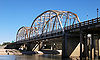 |
1930, 1931 | 1996-10-10 | Humble Humble, Texas Humble is a city in Harris County, Texas within the Houston–Sugar Land–Baytown metropolitan area.As of the 2000 census, the city population was 14,579. The city shares a zip code with the small Houston neighborhood of Bordersville, although people who live in Bordersville still have Humble... 30°1′35"N 95°15′28"W |
Harris Harris County, Texas As of the 2010 Census, the population of the county was 4,092,459, White Americans made up 56.6% of Harris County's population; non-Hispanic whites represented 33.0% of the population. Black Americans made up 18.9% of the population. Native Americans made up 0.7% of Harris County's population... |
Parker through truss |
| State Highway 3-A Bridge at Cibolo Creek | 1932, 1933 | 1996-10-10 | Schertz Schertz, Texas Schertz is a city in Bexar, Comal, and Guadalupe counties in the U.S. state of Texas within the metropolitan area. The population was 31,465 at the 2010 census.On July 16, 2007 CNNMoney.com rated Schertz one of the best places to live in the United States... 29°30′4"N 98°11′11"W |
Bexar Bexar County, Texas As of the census of 2000, there were 1,392,931 people, 488,942 households, and 345,681 families residing in the county. The population density was 1,117 people per square mile . There were 521,359 housing units at an average density of 418 per square mile... |
Parker through truss | |
| State Highway 3-A Bridge at Plum Creek | 1930, 1931 | 1996-10-10 | Luling Luling, Texas Luling is a city in Caldwell County, Texas, United States, along the San Marcos River. The population was 5,080 at the 2000 census. There is some debate as to how Luling got its name. Some say it was named for a Chinese railroad worker, others for a judge named Luling, or that it was the maiden... 29°39′19"N 97°36′3"W |
Caldwell Caldwell County, Texas Caldwell County is a county located in the U.S. state of Texas. It is part of the Austin-Round Rock metropolitan area. In 2000, the population was 32,194. Its county seat is Lockhart... |
Parker through truss | |
| State Highway 5 Bridge at High Creek | 1920, 1921, 1935 | 1996-10-10 | Brookston Brookston, Texas Brookston is an unincorporated community in Lamar County, Texas, United States.The Chisum Independent School District serves area students.-External links:... 33°36′43"N 95°44′50"W |
Lamar | Warren pony truss | |
| State Highway 53 Bridge at the Leon River | 1938, 1939 | 1996-10-10 | Belton Belton, Texas Belton is a city in Bell County, Texas, United States. The population was 14,623 at the 2000 census. It is the county seat of Bell County.Belton is part of the Killeen – Temple – Fort Hood metropolitan area.-Geography:... 31°3′58"N 97°26′32"W |
Bell Bell County, Texas Bell County is a county located in the U.S. state of Texas. Bell County was founded in 1850. It is part of the Killeen–Temple–Fort Hood Metropolitan Statistical Area. In 2000, the county's population was 237,974; in 2010 the U.S. Census Bureau reported that its population had reached... |
Parker through truss | |
| State Highway 71 Bridge at the Colorado River | 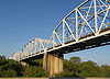 |
1940, 1941 | 1996-10-10 | La Grange La Grange, Texas La Grange is a city in Fayette County, Texas, near the Colorado River. The population was 4,478 at the 2000 census. The 2006 estimated population was 4,645. But a 2010 census estimated that the city had a population of 4,923... 29°54′0"N 96°53′19"W |
Fayette Fayette County, Texas Fayette County is a county located in the U.S. state of Texas. As of 2000, the population was 21,804. Its county seat is La Grange. Fayette is named for the Marquis de la Fayette, a French nobleman who became an American Revolutionary War hero... |
Parker through truss |
| State Highway 78 Bridge at the Red River | 1937, 1938 | 1996-12-20 | Ravenna Ravenna, Texas Ravenna is a city in Fannin County, Texas, United States. The population was 215 at the 2000 census.-Geography:Ravenna is located at .According to the United States Census Bureau, the city has a total area of , all of it land.... 33°45′10"N 96°11′45"W |
Fannin Fannin County, Texas As of the census of 2000, there were 31,242 people, 11,105 households, and 7,984 families residing in the county. The population density was 35 people per square mile . There were 12,887 housing units at an average density of 14 per square mile... |
K through truss | |
| State Highway 79 Bridge at the Red River | 1939 | 1996-12-20 | Byers Byers, Texas Byers is a city in Clay County, Texas, United States. It is part of the Wichita Falls, Texas Metropolitan Statistical Area. The population was 517 at the 2000 census.-Geography:Byers is located at .... 34°7′58"N 98°5′26"W |
Clay Clay County, Texas As of the census of 2000, there were 11,006 people, 4,323 households, and 3,181 families residing in the county. The population density was 10 people per square mile . There were 4,992 housing units at an average density of 4 per square mile... |
Camelback pony truss | |
| State Highway 89 Bridge at the Brazos River | 1933, 1934 | 1996-10-10 | Millsap Millsap, Texas Millsap is a town in Parker County, Texas, United States. The population was 353 at the 2000 census.-Geography:Millsap is located at .... 32°40′0"N 98°1′59"W |
Parker Parker County, Texas As of the census of 2003, there were 98,495 people, 31,131 households, and 24,313 families residing in the county. The population density was 98 people per square mile . There were 34,084 housing units at an average density of 38 per square mile... |
Parker through truss | |
| State Highway 9 Bridge at the Llano River | 1936 | 1996-10-10 | Mason Mason, Texas Mason is the seat of Mason County, Texas, United States. The town is an agricultural community on Comanche Creek southwest of Mason Mountain, on the Edwards Plateau and part of the Llano Uplift. The population was 2,114 at the 2010 census.-History:... 30°39′40"N 99°6′34"W |
Mason Mason County, Texas Mason County is a county located on the Edwards Plateau in the U.S. state of Texas. In 2010, its population was 4, 012. Its county seat is Mason... |
Warren polygonal chord truss | |
| State Highway Bridge 5 at Big Pine Creek | 1920, 1921, 1935 | 1996-10-10 | Brookston Brookston, Texas Brookston is an unincorporated community in Lamar County, Texas, United States.The Chisum Independent School District serves area students.-External links:... 33°39′39"N 95°40′23"W |
Lamar | Warren pony truss | |
| Telephone Road Bridge over Brays Bayou | 1931 | 2007-11-29 | Houston Houston, Texas Houston is the fourth-largest city in the United States, and the largest city in the state of Texas. According to the 2010 U.S. Census, the city had a population of 2.1 million people within an area of . Houston is the seat of Harris County and the economic center of , which is the ... 29°42′32"N 95°18′48.5"W |
Harris Harris County, Texas As of the 2010 Census, the population of the county was 4,092,459, White Americans made up 56.6% of Harris County's population; non-Hispanic whites represented 33.0% of the population. Black Americans made up 18.9% of the population. Native Americans made up 0.7% of Harris County's population... |
Continuous span concrete | |
| Texas and New Orleans Railroad Bridge | 1903 | 1993-03-18 | Wharton Wharton, Texas Wharton is a city in Wharton County, Texas, United States. The population was 9,237 at the 2000 census. It is the county seat of Wharton County and is located on the Colorado River of Texas just south of U.S... 29°18′26"N 96°6′23"W |
Wharton | Camelback/Pratt through truss | |
| US 190 Bridge at the Colorado River | 1939, 1940 | 1996-10-10 | Lometa Lometa, Texas Lometa is a city in Lampasas County, Texas, United States. The population was 782 at the 2000 census. It is part of the Killeen–Temple–Fort Hood Metropolitan Statistical Area.-Geography:Lometa is located at .... 31°13′4"N 98°33′50"W |
Lampasas Lampasas County, Texas Lampasas County is a county located on the Edwards Plateau in the U.S. state of Texas. In 2000, its population was 17,762. Its seat is Lampasas. The county is named for the Lampasas River.... |
Warren polygonal chord truss | |
| US 190 Bridge at the Neches River | 1941, 1943 | 1996-10-10 | Jasper Jasper, Texas Jasper is the county seat of Jasper County, Texas, in the United States. The population was 8,247 at the 2000 census. Jasper is situated in the Deep East Texas subregion, about northeast of Houston. The city is best known for the 1998 murder of James Byrd, Jr., an event which gained national... 30°51′11.75"N 94°11′53.5"W |
Jasper | Parker through truss | |
| US 281 Bridge at the Brazos River | 1938, 1939 | 1996-10-10 | Santo Santo, Texas Santo is an unincorporated community in Palo Pinto County, Texas, United States. It lies on Farm to Market Road 4, fourteen miles south of Palo Pinto, and has an estimated population of 315.-Education:... 32°38′29"N 98°6′0"W |
Palo Pinto Palo Pinto County, Texas As of the census of 2000, there were 27,026 people, 10,594 households, and 7,447 families residing in the county. The population density was 28 people per square mile . There were 14,102 housing units at an average density of 15 per square mile... |
Warren polygonal chord truss | |
| US 83 Bridge at the Salt Fork of the Red River | 1939 | 1996-10-10 | Wellington Wellington, Texas Wellington is a city in Collingsworth County, Texas, United States. The population was 2,275 at the 2000 census. It is the county seat of Collingsworth County.-Geography:Wellington is located at .... 34°57′28"N 100°13′15"W |
Collingsworth | Parker through truss | |
| Waco Suspension Bridge Waco Suspension Bridge The Waco Suspension Bridge crosses the Brazos River in Waco, Texas. It is a single-span suspension bridge with a main span of 475 feet . Opened in 1869, it contains nearly 3 million bricks. It is located north of Downtown Waco, connecting Indian Springs Park with Doris D. Miller Park... |
 |
1870 | 1970-06-22 | Waco Waco, Texas Waco is a city in and the county seat of McLennan County, Texas. Situated along the Brazos River and on the I-35 corridor, halfway between Dallas and Austin, it is the economic, cultural, and academic center of the 'Heart of Texas' region.... |
McLennan McLennan County, Texas McLennan County is a county located on the Edwards Plateau in Central Texas. In 2000, its population was 213,517; in 2008 the U.S. Census Bureau estimated its population to be 230,213. Its seat is Waco. The county is named for Neil McLennan, an early settler.... |
Suspension |
| Washburn Tunnel Washburn Tunnel The Washburn Tunnel is a two-lane underwater motor-vehicle tunnel connecting Galena Park and Pasadena, two suburbs of Houston, Texas. Completed in 1950, it travels north-south underneath the Houston Ship Channel. It was named after Harris County, Texas Auditor Harry L. Washburn... |
1947 | 2008-4-16 | Houston Houston, Texas Houston is the fourth-largest city in the United States, and the largest city in the state of Texas. According to the 2010 U.S. Census, the city had a population of 2.1 million people within an area of . Houston is the seat of Harris County and the economic center of , which is the ... 29°43′35"N 95°12′43"W |
Harris Harris County, Texas As of the 2010 Census, the population of the county was 4,092,459, White Americans made up 56.6% of Harris County's population; non-Hispanic whites represented 33.0% of the population. Black Americans made up 18.9% of the population. Native Americans made up 0.7% of Harris County's population... |
Subaqueous tunnel | |
| Washington Avenue Bridge Washington Avenue Bridge (Waco, Texas) The Washington Avenue Bridge in Waco, Texas was built in 1902. It was listed on the National Register of Historic Places in 1998.... |
 |
1902 | 1998-02-20 | Waco Waco, Texas Waco is a city in and the county seat of McLennan County, Texas. Situated along the Brazos River and on the I-35 corridor, halfway between Dallas and Austin, it is the economic, cultural, and academic center of the 'Heart of Texas' region.... 31°33′40"N 97°7′43"W |
McLennan McLennan County, Texas McLennan County is a county located on the Edwards Plateau in Central Texas. In 2000, its population was 213,517; in 2008 the U.S. Census Bureau estimated its population to be 230,213. Its seat is Waco. The county is named for Neil McLennan, an early settler.... |
Pennsylvania through truss |