

List of St. Louis MetroLink stations
Encyclopedia
St. Louis Metrolink
MetroLink is the light rail transit system in the Greater St. Louis area of Missouri and the Metro East area of Illinois. The entire system currently consists of two lines connecting Lambert-St. Louis International Airport and Shrewsbury, MO with Scott Air Force Base near Shiloh, Illinois through...
is a light rail
Light rail
Light rail or light rail transit is a form of urban rail public transportation that generally has a lower capacity and lower speed than heavy rail and metro systems, but higher capacity and higher speed than traditional street-running tram systems...
transit system serving the Greater St. Louis area. The system is operated by the Bi-State Development Agency
Bi-State Development Agency
The Bi-State Development Agency is an interstate compact formed by Missouri and Illinois in 1949. Since February 2003 the agency has been doing business as Metro. It operates with a budget of $160 million, which is funded by sales taxes from the City of St. Louis and St. Louis County, the St...
, which since 2003 is doing business as
Doing business as
The phrase "doing business as" is a legal term used in the United States, meaning that the trade name, or fictitious business name, under which the business or operation is conducted and presented to the world is not the legal name of the legal person who actually own it and are responsible for it...
Metro. Serving over 67,000 passengers a day, MetroLink is one of the largest light rail systems in the United States in terms of ridership.
MetroLink began service on July 31, 1993 with the opening of the Red Line segment from North Hanley
North Hanley (St. Louis Metrolink)
North Hanley is a St. Louis MetroLink Station, located by the North Hanley overpass of I-70. It is primarily a commuter station featuring 1583 Park-Ride spaces . The station also serves as a major bus transfer center for Metro in North St...
to 5th & Missouri
5th & Missouri (St. Louis MetroLink)
5th & Missouri is a St. Louis MetroLink station located in East St. Louis, Illinois. The station features 322 Park-Ride spaces, including 25 long term spaces.-MetroBus:*1 Main Street-State St*2 Cahokia*4 Bond Ave-19th & Central...
. An extension to Lambert-St. Louis International Airport
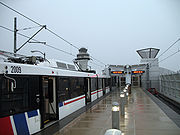
Lambert-St. Louis International Airport
Lambert-St. Louis International Airport is a Class B international airport serving Greater St. Louis. It is located approximately northwest of downtown St. Louis in unincorporated St. Louis County between Berkeley and Bridgeton. It is the largest and busiest airport in the state with 250 daily...
was opened a year later. Since then, the system has had two major expansions. The first expansion, known as the St. Clair County Extension, was completed on May 5, 2001 with the extension of the Red Line to Belleville, Illinois
Belleville, Illinois
Belleville is a city in St. Clair County, Illinois, United States. As of the 2010 census, the city has a population of 44,478. It is the eighth-most populated city outside of the Chicago Metropolitan Area and the most populated city south of Springfield in the state of Illinois. It is the county...
and two years later to Scott Air Force Base
Scott Air Force Base
Scott Air Force Base is a base of the United States Air Force in St. Clair County, Illinois, near Belleville.-Overview:The base is named after Corporal Frank S. Scott, the first enlisted person to be killed in an aviation crash...
. The second major expansion, known as the Cross County Extension, was completed on August 26, 2006 with the addition of the Blue Line from the Forest Park-DeBaliviere
Forest Park-DeBaliviere (St. Louis Metrolink)
Forest Park-DeBaliviere is a St. Louis MetroLink subway station, located at the northeast corner of Forest Park Parkway and DeBaliviere Avenue in St. Louis. This station is located just to the north of Forest Park. Attractions in the park include the St. Louis Art Museum, St...
station to the Shrewsbury-Lansdowne I-44
Shrewsbury-Lansdowne I-44 (St. Louis Metrolink)
The Shrewsbury–Lansdowne I-44 St. Louis MetroLink station is located on Lansdowne Ave at River Des Peres Boulevard in Shrewsbury and St. Louis, Missouri, near Interstate 44. The city limits line between the two communities runs through the station and parking facilities...
station via Clayton, Missouri
Clayton, Missouri
Clayton is an inner-ring suburb of St. Louis and the county seat of St. Louis County, Missouri. The population was 15,939 at the 2010 census. The city was organized in 1877 and is named after Ralph Clayton, who donated the land for the courthouse.-Geography:...
.
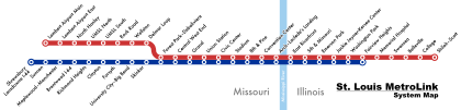
The system currently has 37 stations, of which 28 stations are served by the Red Line and 24 stations are served by the Blue Line. There are 15 stations that are served by both lines. The city of St. Louis
St. Louis, Missouri
St. Louis is an independent city on the eastern border of Missouri, United States. With a population of 319,294, it was the 58th-largest U.S. city at the 2010 U.S. Census. The Greater St...
and St. Louis County
St. Louis County, Missouri
St. Louis County is a county located in the U.S. state of Missouri. Its county seat is Clayton. St. Louis County is part of the St. Louis Metro Area wherein the independent City of St. Louis and its suburbs in St. Louis County, as well as the surrounding counties in both Missouri and Illinois all...
in Missouri
Missouri
Missouri is a US state located in the Midwestern United States, bordered by Iowa, Illinois, Kentucky, Tennessee, Arkansas, Oklahoma, Kansas and Nebraska. With a 2010 population of 5,988,927, Missouri is the 18th most populous state in the nation and the fifth most populous in the Midwest. It...
have 12 and 14 stations, respectively, with the remaining 11 stations located in St. Clair County, Illinois
St. Clair County, Illinois
St. Clair County is a county located in the U.S. state of Illinois. In 1970, the U.S. Census Bureau placed the mean center of U.S. population in St. Clair County. According to the 2010 census, it has a population of 270,056, which is an increase of 5.5% from 256,082 in 2000. Its county seat is...
. In terms of daily ridership, Central West End
Central West End (St. Louis Metrolink)
Central West End is a St. Louis MetroLink Station, located in the Central West End at the intersection of Euclid Avenue and Children's Place. This station services the Washington University Medical Center, Barnes-Jewish Hospital, St. Louis Children's Hospital, and St. Louis University High...
is the most heavily used station, while Sunnen
Sunnen (St. Louis Metrolink)
The Sunnen St. Louis MetroLink station is located at 21 Sunnen Dr in Maplewood, at the headquarters of Sunnen Products. This station is accessible by stairs and ramps to reach both the Eastbound and Westbound Platforms. The Sunnen station is also adjacent to the only at grade crossing on the...
is the least.
Stations
| * | Official transfer stations |
| † | Terminals |
| Station | City | Opened | ||
|---|---|---|---|---|
| 5th & Missouri 5th & Missouri (St. Louis MetroLink) 5th & Missouri is a St. Louis MetroLink station located in East St. Louis, Illinois. The station features 322 Park-Ride spaces, including 25 long term spaces.-MetroBus:*1 Main Street-State St*2 Cahokia*4 Bond Ave-19th & Central... |
Red Blue |
East St. Louis East St. Louis, Illinois East St. Louis is a city located in St. Clair County, Illinois, USA, directly across the Mississippi River from St. Louis, Missouri in the Metro-East region of Southern Illinois. As of the 2010 census, the city had a total population of 27,006, less than one-third of its peak of 82,366 in 1950... |
2,501 | |
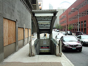
| 8th & Pine 8th & Pine (St. Louis Metrolink) 8th & Pine is a St. Louis MetroLink subway station. This station is located in downtown St. Louis, Missouri. This station primarily serves the Downtown Business District, its residents, and commuters. It was one of six MetroLink stations in the Downtown St... |
Red Blue |
St. Louis St. Louis, Missouri St. Louis is an independent city on the eastern border of Missouri, United States. With a population of 319,294, it was the 58th-largest U.S. city at the 2010 U.S. Census. The Greater St... |
2,851 | |
| Arch-Laclede's Landing Arch-Laclede's Landing (St. Louis Metrolink) Arch – Laclede's Landing is a St. Louis MetroLink Station. It is located near Laclede's Landing and the Gateway Arch in downtown St. Louis, Missouri. This station is also nearby the headquarters for Bi-State Development Agency , the operator of MetroLink and Metrobus Service. It was one of six... |
Red Blue |
St. Louis St. Louis, Missouri St. Louis is an independent city on the eastern border of Missouri, United States. With a population of 319,294, it was the 58th-largest U.S. city at the 2010 U.S. Census. The Greater St... |
1,209 | |
| Belleville Belleville (St. Louis MetroLink) -MetroBus:* 1 Main St - State St* 15 Lebanon Avenue* 16 St. Clair Square* 17 Carlyle Plaza-17th Street* 512X MetroLink Station Shuttle... |
Red | Belleville Belleville, Illinois Belleville is a city in St. Clair County, Illinois, United States. As of the 2010 census, the city has a population of 44,478. It is the eighth-most populated city outside of the Chicago Metropolitan Area and the most populated city south of Springfield in the state of Illinois. It is the county... |
892 | |
| Brentwood I-64 Brentwood I-64 (St. Louis Metrolink) The Brentwood I-64 St. Louis MetroLink station is located on Eager Road between Brentwood Boulevard and S. Hanley Road in Brentwood, just southeast of the Interstate 64/Interstate 170 interchange. It opened August 26, 2006 along with the rest of the Cross-County Extension.The station includes 900... |
Blue | Brentwood Brentwood, Missouri Brentwood is an inner-ring suburb of St. Louis, located in St. Louis County, Missouri. The population was 8,055 at the 2010 census. Brentwood is home to Brentwood High School, a 2006 National Blue Ribbon Award winner, and Mark Twain Elementary School, a 2009 National Blue Ribbon Award... |
1,051 | |
| Central West End Central West End (St. Louis Metrolink) Central West End is a St. Louis MetroLink Station, located in the Central West End at the intersection of Euclid Avenue and Children's Place. This station services the Washington University Medical Center, Barnes-Jewish Hospital, St. Louis Children's Hospital, and St. Louis University High... |
Red Blue |
St. Louis St. Louis, Missouri St. Louis is an independent city on the eastern border of Missouri, United States. With a population of 319,294, it was the 58th-largest U.S. city at the 2010 U.S. Census. The Greater St... |
6,232 | |
| Civic Center Civic Center (St. Louis Metrolink) Civic Center is a St. Louis MetroLink station. The station is located near the Scottrade Center, home of the St. Louis Blues, Sheraton City Center Hotel, Soldiers Memorial, and the Saint Louis Public Library Central Library. It was one of six MetroLink stations in the Downtown St... |
Red Blue |
St. Louis St. Louis, Missouri St. Louis is an independent city on the eastern border of Missouri, United States. With a population of 319,294, it was the 58th-largest U.S. city at the 2010 U.S. Census. The Greater St... |
2,852 | |
| Clayton Clayton (St. Louis Metrolink) Clayton is a St. Louis MetroLink station that opened August 26, 2006. This at-grade station is located in the median of Forest Park Parkway between S. Central Ave and S. Meramec Ave, and serves the Clayton Central Business District, St. Louis County Government Complex and area residents... |
Blue | Clayton Clayton, Missouri Clayton is an inner-ring suburb of St. Louis and the county seat of St. Louis County, Missouri. The population was 15,939 at the 2010 census. The city was organized in 1877 and is named after Ralph Clayton, who donated the land for the courthouse.-Geography:... |
923 | |
| College College (St. Louis Metrolink) College Station is a St. Louis MetroLink station that is located at Southwestern Illinois College in Saint Clair County, Illinois. The station is east of Belleville, Illinois on Illinois Route 161 1and west of Scott Air Force Base.- External links :*... |
Red | Belleville Belleville, Illinois Belleville is a city in St. Clair County, Illinois, United States. As of the 2010 census, the city has a population of 44,478. It is the eighth-most populated city outside of the Chicago Metropolitan Area and the most populated city south of Springfield in the state of Illinois. It is the county... |
692 | |
| Convention Center Convention Center (St. Louis Metrolink) Convention Center is a St. Louis MetroLink subway station. This is located at Sixth Street and Washington Avenue near the Edward Jones Dome, America's Center, Renaissance Grand Hotel, and Renaissance Saint Louis Suites Hotel in St. Louis, Missouri. It was one of six MetroLink stations in the... |
Red Blue |
St. Louis St. Louis, Missouri St. Louis is an independent city on the eastern border of Missouri, United States. With a population of 319,294, it was the 58th-largest U.S. city at the 2010 U.S. Census. The Greater St... |
3,473 | |
| Delmar Loop Delmar Loop (St. Louis Metrolink) Delmar Loop is a St. Louis MetroLink Station. This station features 362 Park-Ride spaces. It is adjacent to the Delmar Loop entertainment district that straddles St. Louis and St. Louis County. Nearby attractions include the restored Tivoli Theater as well as the new Pageant Theater along with... |
Red | St. Louis St. Louis, Missouri St. Louis is an independent city on the eastern border of Missouri, United States. With a population of 319,294, it was the 58th-largest U.S. city at the 2010 U.S. Census. The Greater St... |
2,721 | |
| East Riverfront East Riverfront (St. Louis Metrolink) East Riverfront is a St. Louis MetroLink station. The station is located by the Casino Queen in East St. Louis.- External links :*... |
Red Blue |
East St. Louis East St. Louis, Illinois East St. Louis is a city located in St. Clair County, Illinois, USA, directly across the Mississippi River from St. Louis, Missouri in the Metro-East region of Southern Illinois. As of the 2010 census, the city had a total population of 27,006, less than one-third of its peak of 82,366 in 1950... |
854 | |
| Emerson Park Emerson Park (St. Louis MetroLink) Emerson Park is a St. Louis MetroLink station. This station features 816 Park-Ride spaces.- External links :*... |
Red Blue |
East St. Louis East St. Louis, Illinois East St. Louis is a city located in St. Clair County, Illinois, USA, directly across the Mississippi River from St. Louis, Missouri in the Metro-East region of Southern Illinois. As of the 2010 census, the city had a total population of 27,006, less than one-third of its peak of 82,366 in 1950... |
2,201 | |
| Fairview Heights Fairview Heights (St. Louis MetroLink) Fairview Heights is a St. Louis MetroLink station in Fairview Heights, Illinois, on Illinois Route 161.-MetroBus:* 1 Main – State St* 12 O'Fallon – Fairview Heights* 13 Caseyville – Maryville* 16 St. Clair Square* 512X MetroLink Station Shuttle... † |
Red Blue |
Fairview Heights Fairview Heights, Illinois Fairview Heights is a city in St. Clair County, Illinois, United States. The population was 17,078 at the 2010 census. Fairview Heights is a dominant shopping center for Southwestern Illinois and includes numerous shopping plazas and the St... |
1,380 | |
| Forest Park-DeBaliviere Forest Park-DeBaliviere (St. Louis Metrolink) Forest Park-DeBaliviere is a St. Louis MetroLink subway station, located at the northeast corner of Forest Park Parkway and DeBaliviere Avenue in St. Louis. This station is located just to the north of Forest Park. Attractions in the park include the St. Louis Art Museum, St... * |
Red Blue |
St. Louis St. Louis, Missouri St. Louis is an independent city on the eastern border of Missouri, United States. With a population of 319,294, it was the 58th-largest U.S. city at the 2010 U.S. Census. The Greater St... |
5,438 | |
| Forsyth Forsyth (St. Louis Metrolink) The Forsyth St. Louis MetroLink station opened August 26, 2006. This below-grade, open-air station is located at the intersection of Forest Park Parkway and Forsyth Boulevard on the border of University City and Clayton.... |
Blue | University City University City, Missouri University City is an inner-ring suburb in St. Louis County, Missouri. The population was 35,371 in 2010 census. The city was shaped by Washington University in St. Louis, whose campus abuts the city to the southeast.... |
358 | |
| Grand Grand (St. Louis Metrolink) Grand is a St. Louis MetroLink station. This station is located below the Grand Boulevard viaduct. Until spring 2011, the station was accessible by two elevators, stairs, and a ramp on Scott Avenue. In March 2011, the station was temporarily closed to permit the demolition of the Grand Boulevard... |
Red Blue |
St. Louis St. Louis, Missouri St. Louis is an independent city on the eastern border of Missouri, United States. With a population of 319,294, it was the 58th-largest U.S. city at the 2010 U.S. Census. The Greater St... |
4,455 | |
| Jackie Joyner-Kersee Center Jackie Joyner-Kersee Center (St. Louis MetroLink) Jackie Joyner-Kersee Center is a St. Louis MetroLink station. It is adjacent to the Jackie Joyner-Kersee Youth Center.... |
Red Blue |
East St. Louis East St. Louis, Illinois East St. Louis is a city located in St. Clair County, Illinois, USA, directly across the Mississippi River from St. Louis, Missouri in the Metro-East region of Southern Illinois. As of the 2010 census, the city had a total population of 27,006, less than one-third of its peak of 82,366 in 1950... |
1,118 | |
| Lambert Airport East Lambert Airport East (St. Louis Metrolink) Lambert Airport East is a St. Louis MetroLink station. It is located at the East Terminal of Lambert-St. Louis International Airport, Missouri, United States, serving Southwest Airlines.- External links :*... |
Red | Unincorporated | 1,095 | |
| Lambert Airport Main Lambert Airport Main (St. Louis Metrolink) Lambert Airport Main is a St. Louis MetroLink Station. The station is located at the Lambert-St. Louis International Airport, Missouri, United States... † |
Red | Unincorporated | 3,978 | |
| Maplewood-Manchester Maplewood-Manchester (St. Louis Metrolink) The Maplewood–Manchester St. Louis MetroLink station is located on Manchester Road between S. Hanley Rd and Laclede Station Rd in Maplewood. This station has entrances on the northside of Manchester and the southside of Manchester . This station serves area residents and The Maplewood Commons... |
Blue | Maplewood Maplewood, Missouri Maplewood is an inner-ring suburb of St. Louis, located in St. Louis County. The population was 8,046 at the 2010 census.-Geography:Maplewood is located at .... |
705 | |
| Memorial Hospital Memorial Hospital (St. Louis MetroLink) Memorial Hospital is a St. Louis MetroLink station in Belleville, Illinois, near the intersection of Illinois Route 161 and Frank Scott Parkway.- External links :*... |
Red | Belleville Belleville, Illinois Belleville is a city in St. Clair County, Illinois, United States. As of the 2010 census, the city has a population of 44,478. It is the eighth-most populated city outside of the Chicago Metropolitan Area and the most populated city south of Springfield in the state of Illinois. It is the county... |
594 | |
| North Hanley North Hanley (St. Louis Metrolink) North Hanley is a St. Louis MetroLink Station, located by the North Hanley overpass of I-70. It is primarily a commuter station featuring 1583 Park-Ride spaces . The station also serves as a major bus transfer center for Metro in North St... |
Red | Berkeley Berkeley, Missouri Berkeley is an inner-ring suburb of St. Louis, located in St. Louis County, Missouri, United States. The population was 8,978 at the 2010 census. Portions of Lambert-St... |
3,939 | |
| Richmond Heights Richmond Heights (St. Louis Metrolink) The Richmond Heights St. Louis MetroLink station is located at the interchange of Interstate 170 and Galleria Parkway in Richmond Heights, just east of the Saint Louis Galleria shopping center. This station serves the Residence Inn by Marriott Hotel, The Boulevard-Saint Louis, and The Saint Louis... |
Blue | Richmond Heights Richmond Heights, Missouri Richmond Heights, a city in St. Louis County, is an inner-ring suburb of St. Louis, Missouri. The population was 8,603 at the 2010 census. According to Robert L. Ramsay, the name was suggested by Robert E. Lee, who thought the topography of the area resembled Richmond, Virginia... |
829 | |
| Rock Road Rock Road (St. Louis Metrolink) Rock Road is a St. Louis MetroLink Station. This station features 183 Park-Ride spaces. The station's name comes from St. Charles Rock Road, an important East-West link in St. Louis County.-MetroBus:*2 WUSTL-Red*30 Soulard*32 M. L. King-Chouteau... |
Red | Pagedale Pagedale, Missouri Pagedale is a city in St. Louis County, Missouri, United States. The population was 3,304 at the 2010 census.-Geography:Pagedale is located at .... |
2,408 | |
| Shiloh-Scott Shiloh-Scott (St. Louis MetroLink) Shiloh-Scott is a St. Louis MetroLink station located adjacent to Scott Air Force Base in Shiloh, IL and is the eastern terminus of the MetroLink system. It opened on June 23, 2003 as part of Phase 2 of the St. Clair County Extension which extended MetroLink from College to Shiloh-Scott station... † |
Red | Shiloh Shiloh, Illinois Shiloh is a village in St. Clair County, Illinois, United States. A 2005 census recorded a population of 11,000.-Geography:Shiloh is located at .... |
1,409 | |
| Shrewsbury-Lansdowne I-44 Shrewsbury-Lansdowne I-44 (St. Louis Metrolink) The Shrewsbury–Lansdowne I-44 St. Louis MetroLink station is located on Lansdowne Ave at River Des Peres Boulevard in Shrewsbury and St. Louis, Missouri, near Interstate 44. The city limits line between the two communities runs through the station and parking facilities... † |
Blue | St. Louis St. Louis, Missouri St. Louis is an independent city on the eastern border of Missouri, United States. With a population of 319,294, it was the 58th-largest U.S. city at the 2010 U.S. Census. The Greater St... |
2,362 | |
| Skinker Skinker (St. Louis Metrolink) The Skinker St. Louis MetroLink subway station opened August 26, 2006 at the intersection of Skinker Boulevard and Forest Park Parkway near the boundary of St. Louis and University City, and serves the eastern portion of the Washington University main campus, the western portion of Forest Park, and... |
Blue | St. Louis St. Louis, Missouri St. Louis is an independent city on the eastern border of Missouri, United States. With a population of 319,294, it was the 58th-largest U.S. city at the 2010 U.S. Census. The Greater St... |
736 | |
| Stadium Stadium (St. Louis Metrolink) Stadium is a St. Louis MetroLink station. This station serves Busch Stadium, home of the St. Louis Cardinals, , Westin Saint Louis Hotel and the future Ballpark Village in St. Louis, Missouri. It was one of six MetroLink stations in the Downtown St... |
Red Blue |
St. Louis St. Louis, Missouri St. Louis is an independent city on the eastern border of Missouri, United States. With a population of 319,294, it was the 58th-largest U.S. city at the 2010 U.S. Census. The Greater St... |
787 | |
| Sunnen Sunnen (St. Louis Metrolink) The Sunnen St. Louis MetroLink station is located at 21 Sunnen Dr in Maplewood, at the headquarters of Sunnen Products. This station is accessible by stairs and ramps to reach both the Eastbound and Westbound Platforms. The Sunnen station is also adjacent to the only at grade crossing on the... |
Blue | Maplewood Maplewood, Missouri Maplewood is an inner-ring suburb of St. Louis, located in St. Louis County. The population was 8,046 at the 2010 census.-Geography:Maplewood is located at .... |
333 | |
| Swansea Swansea (St. Louis Metrolink) The Swansea MetroLink station lies in between two major Illinois Highways, IL 159 and IL 161. Amenities nearby include a Schnucks supermarket , a Phillips 66, McDonald's, Walgreens, Wendy's, Applebee's, FCB Bank, UMB Bank, and a U.S. Bank branch inside Schnucks.- External links :*... |
Red | Swansea Swansea, Illinois Swansea is a village in St. Clair County, Illinois, United States. The population was 10,579 at the 2000 census.-History:In the late 19th century the area that is now Swansea was a mix of farming and commerce. It was home to underground coal mines, foundries, brickyards, and the Gundlach Drill... |
698 | |
| UMSL North UMSL North (St. Louis Metrolink) UMSL North is a St. Louis MetroLink Station. This station features 100 Park-Ride spaces. The station sits adjacent to the University of Missouri–St. Louis' Touhill Performing Arts Center on the university's North Campus.-External links:*... |
Red | Normandy Normandy, Missouri Normandy is a city in St. Louis County, Missouri, United States. The population was 5,008 at the 2010 census.-History:The town is on land once owned by Charles Lucas. Lucas obtained property from the federal government with land grants, and he purchased the land from victims of the New Madrid... |
828 | |
| UMSL South UMSL South (St. Louis Metrolink) UMSL South is a St. Louis MetroLink Station. This station features 130 Park-Ride spaces. The station sits adjacent to the University of Missouri–St. Louis' South Campus.-External links:*... |
Red | Normandy Normandy, Missouri Normandy is a city in St. Louis County, Missouri, United States. The population was 5,008 at the 2010 census.-History:The town is on land once owned by Charles Lucas. Lucas obtained property from the federal government with land grants, and he purchased the land from victims of the New Madrid... |
1,105 | |
| Union Station Union Station (St. Louis Metrolink) Union Station is a St. Louis MetroLink station. This station is adjacent to Union Station in St. Louis, Missouri. It was one of six MetroLink stations in the Downtown St. Louis Ride Free Zone at lunch time on weekdays prior to the 2009 service reduction.The station is on the 18th Street side of... |
Red Blue |
St. Louis St. Louis, Missouri St. Louis is an independent city on the eastern border of Missouri, United States. With a population of 319,294, it was the 58th-largest U.S. city at the 2010 U.S. Census. The Greater St... |
2,953 | |
| University City-Big Bend University City-Big Bend (St. Louis Metrolink) The University City–Big Bend St. Louis MetroLink subway station, opened on August 26, 2006, serves the western portion of the Washington University's main campus , and the southern part of the Delmar Loop... |
Blue | University City University City, Missouri University City is an inner-ring suburb in St. Louis County, Missouri. The population was 35,371 in 2010 census. The city was shaped by Washington University in St. Louis, whose campus abuts the city to the southeast.... |
555 | |
| Washington Park Washington Park (St. Louis MetroLink) - External links :*... |
Red Blue |
Washington Park Washington Park, Illinois Washington Park is a village in St. Clair County, Illinois, United States. The population was 5,345 at the 2000 census.-History:Washington Park filed for Chapter 9 bankruptcy protection in July, 2009, citing assets of less than $50,000 and debt of more than $1 million... |
677 | |
| Wellston Wellston (St. Louis Metrolink) Wellston is a St. Louis MetroLink Station. This station features 243 Park-Ride spaces. It also features a connection to St. Louis' only bus line that runs on its own exclusive right-of-way, the Hodiamont Line... |
Red | Wellston Wellston, Missouri Wellston is a city in St. Louis County, Missouri, United States, along the northwest border of the city of St. Louis. The population was 2,313 at the 2010 census.-History:... |
1,569 |