

Lawyer's Head
Encyclopedia
Otago
Otago is a region of New Zealand in the south of the South Island. The region covers an area of approximately making it the country's second largest region. The population of Otago is...
, New Zealand
New Zealand
New Zealand is an island country in the south-western Pacific Ocean comprising two main landmasses and numerous smaller islands. The country is situated some east of Australia across the Tasman Sea, and roughly south of the Pacific island nations of New Caledonia, Fiji, and Tonga...
. Located within the city of Dunedin
Dunedin
Dunedin is the second-largest city in the South Island of New Zealand, and the principal city of the Otago Region. It is considered to be one of the four main urban centres of New Zealand for historic, cultural, and geographic reasons. Dunedin was the largest city by territorial land area until...
, this rocky headland juts into the Pacific Ocean
Pacific Ocean
The Pacific Ocean is the largest of the Earth's oceanic divisions. It extends from the Arctic in the north to the Southern Ocean in the south, bounded by Asia and Australia in the west, and the Americas in the east.At 165.2 million square kilometres in area, this largest division of the World...
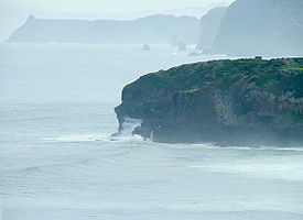
at the eastern end of the city's main beach, Saint Kilda Beach. It is named for the likeness of the cliff face to the profile of a lawyer in traditional legal wig.
Lawyers Head, which reaches a height of 60 m, is connected to the city by the road John Wilson Ocean Drive, which runs parallel to the beach. The head itself commands a view across the city's southern suburbs and along the Otago coast for over 80 kilometres to the southwest. On a clear day Nugget Point
Nugget Point
Nugget Point is one of the most iconic landforms on the Otago coast. Located at the northern end of the Catlins coast down the road from Kaka Point, this steep headland has a lighthouse at its tip, surrounded by rocky islets...
in The Catlins
The Catlins
The Catlins comprises an area in the southeastern corner of the South Island of New Zealand. The area lies between Balclutha and Invercargill, straddling the boundary between the Otago and Southland regions...
can be discerned, and the Nugget Point lighthouse's beam can be seen at night. To the east, the suburb of Ocean Grove
Ocean Grove, New Zealand
Ocean Grove, also known as Tomahawk, is a suburb in the southeast of the New Zealand city of Dunedin. A semi-rural residential suburb on the Pacific coast at the southwestern end of the Otago Peninsula, Ocean Grove is located southeast of Dunedin city centre.The suburb is isolated from much of the...
and the nearby Tomahawk Lagoon
Tomahawk Lagoon
Tomahawk Lagoon is a twin-lobed lagoon, located at the western end of the Otago Peninsula within the city limits of Dunedin, New Zealand. It lies close to the southeastern edge of the city's main urban area, near the suburb of Ocean Grove, which lies close to its southern shore...
lie beneath the headland.
John Wilson Ocean Drive was closed from August 2006, to allow construction of the Tahuna Wastewater Treatment Plant outfall. The road closure had an unexpected benefit of stopping suicides from the headland; there were 13 deaths in the 10 years prior. Access to the headland was restored briefly in October 2009, but closed when there was another death less than three days after full access was restored. New Zealand Police
New Zealand Police
The New Zealand Police is the national police force of New Zealand, responsible for enforcing criminal law, enhancing public safety, maintaining order and keeping the peace throughout New Zealand...
Inspector Dave Campbell stated "Lawyers Head now has the unenviable reputation of having the highest number of deaths by suicide in one location in New Zealand".
One of a series of headlands which punctuate much of this section of the Otago coast, it is its proximity to the centre of the city and its distinctive shape which make it particularly well known. Other nearby headlands nearby include the slightly higher 75 m Maori Head, one kilometre to the east, the cliffs along the coast of Forbury Hill three kilometres to the west, the natural arch of Tunnel Beach three kilometres beyond Forbury Hill
Saint Clair, New Zealand
St Clair is a leafy residential suburb of the New Zealand city of Dunedin. It is located on the Pacific Ocean coast five kilometres from the city centre on the southwesternmost part of the coastal plain which makes up the southern part of the urban area, and also climbs the slopes of Forbury Hill...
, and Blackhead, two kilometres to the southwest of Tunnel Beach.
These basalt outcrops were all formed during the eruption of the Dunedin Volcano some 12-15 million years ago. The crater of this long-extinct volcano now forms Otago Harbour
Otago Harbour
Otago Harbour is the natural harbour of Dunedin, New Zealand, consisting of a long, much-indented stretch of generally navigable water separating the Otago Peninsula from the mainland. They join at its southwest end, from the harbour mouth...
, and its rim is the ring of hills which circle Dunedin and form the ridge of the Otago Peninsula
Otago Peninsula
The Otago Peninsula is a long, hilly indented finger of land that forms the easternmost part of Dunedin, New Zealand. Volcanic in origin, it forms one wall of the eroded valley that now forms Otago Harbour. The peninsula lies south-east of Otago Harbour and runs parallel to the mainland for...
.
Further reading
- Bishop, D.G., and Turnbull, I.M. (compilers) (1996). Geology of the Dunedin Area. Lower Hutt, NZ: Institute of Geological & Nuclear Sciences. ISBN 0-478-09521-X.
- Dann, C., and Peat, N. (1989). Dunedin, North and South Otago. Wellington: GP Books. ISBN 978-0-477-01438-0.