

Lake O' the Pines
Encyclopedia
Lake O’ the Pines is a reservoir on Big Cypress Bayou, also known as Big Cypress Creek, chiefly in Marion County, Texas
, USA. The reservoir also occupies a small part of Upshur
and Morris
Counties. The dam is located approximately 8.5 miles (13.7 km) west of Jefferson
.
. The reservoir was created as part of the overall plan for flood control in the Red River Basin below Denison Dam
in Oklahoma
. The project was authorized by the Flood Control Act of 1946
. Additional purposes of wildlife conservation, recreation, and water supply were added during construction. The U.S. Army Corps of Engineers
began construction of the dam in January 1955 and the dam was completed on December 11, 1959.
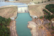 The concrete-and-earthfill dam is 10600 feet (3,231 m) long. The crest of the spillway is 249.5 feet (76 m) above mean sea level. The conservation storage capacity is 250000 acre.ft with a surface area of 18680 acres (76 km²). The bayou has a length of 140 miles (225 km) and a total drainage area of 850 square miles (2,201 km²). The lake’s normal conservation pool is 230 feet (70 m) above mean sea level. The lake provides water supply storage for the Northeast Texas Municipal Water District which serves the cities of Jefferson, Ore City
, Lone Star
, Avinger
, Hughes Springs
, Daingerfield
, and most recently Longview
. The water supply storage exists in the conservation pool between elevations 201 to 230 feet (70.1 m). Water intake structures are located at various points on the lake and one downstream of the lake. Discharges from the two gates in the control structure located on the southeast end vary from a minimum of 5 cuft/s to a maximum of 3000 cuft/s.
Marion County, Texas
As of the census of 2000, there were 10,941 people, 4,610 households, and 3,120 families residing in the county. The population density was 29 people per square mile . There were 6,384 housing units at an average density of 17 per square mile...
, USA. The reservoir also occupies a small part of Upshur
Upshur County, Texas
As of the census of 2000, there were 35,291 people, 13,290 households, and 10,033 families residing in the county. The population density was 60 people per square mile . There were 14,930 housing units at an average density of 25 per square mile...
and Morris
Morris County, Texas
As of the census of 2000, there were 13,048 people, 5,215 households, and 3,749 families residing in the county. The population density was 51 people per square mile . There were 6,017 housing units at an average density of 24 per square mile...
Counties. The dam is located approximately 8.5 miles (13.7 km) west of Jefferson
Jefferson, Texas
Jefferson is an historic city in Marion County in northeastern Texas, United States. The population was 2,024 at the 2000 census. It is the county seat of Marion County, Texas, and is situated in East Texas...
.
History
Lake O’ the Pines (formerly known as "Ferrell's Bridge Reservoir") was created by the construction of the Ferrells Bridge Dam on the Big Cypress Bayou approximately 81 miles (130 km) upstream from the bayou's confluence with the Red RiverRed River (Mississippi watershed)
The Red River, or sometimes the Red River of the South, is a major tributary of the Mississippi and Atchafalaya Rivers in the southern United States of America. The river gains its name from the red-bed country of its watershed. It is one of several rivers with that name...
. The reservoir was created as part of the overall plan for flood control in the Red River Basin below Denison Dam
Denison Dam
Denison Dam, also known as Lake Texoma Dam, is a dam located on the Red River between Texas and Oklahoma that impounds Lake Texoma. The purpose of the dam is flood control, water supply, hydroelectric power production, river regulation, navigation and recreation.-History:Completed in 1943 primarily...
in Oklahoma
Oklahoma
Oklahoma is a state located in the South Central region of the United States of America. With an estimated 3,751,351 residents as of the 2010 census and a land area of 68,667 square miles , Oklahoma is the 28th most populous and 20th-largest state...
. The project was authorized by the Flood Control Act of 1946
Flood Control Act of 1946
The Flood Control Act of 1946 was passed by the United States Congress on July 24, 1946; to authorize 123 projects including several dams and hydroelectric power plants like Old Hickory Lock and Dam in Tennessee and the Fort Randall Dam in South Dakota. It also allowed bank adjustments and...
. Additional purposes of wildlife conservation, recreation, and water supply were added during construction. The U.S. Army Corps of Engineers
United States Army Corps of Engineers
The United States Army Corps of Engineers is a federal agency and a major Army command made up of some 38,000 civilian and military personnel, making it the world's largest public engineering, design and construction management agency...
began construction of the dam in January 1955 and the dam was completed on December 11, 1959.
Dam and reservoir
Ore City, Texas
Ore City is a city in Upshur County, Texas, United States. The population was 1,144 at the 2010 census.-Geography:Ore City is located at . It is situated approximately 13 miles northeast of Gilmer at the junction of U.S...
, Lone Star
Lone Star, Texas
Lone Star is a city in Morris County, Texas, United States. The population was 1,631 at the 2000 census.-Geography:Lone Star is located at ....
, Avinger
Avinger, Texas
Avinger is a town in Cass County, Texas, United States. The population was 464 at the 2000 census.-Geography:Avinger is located at .According to the United States Census Bureau, the town has a total area of , all of it land....
, Hughes Springs
Hughes Springs, Texas
Hughes Springs is a city in Cass and Morris Counties in the U.S. state of Texas. The population was 1,856 at the 2000 census.-Geography:Hughes Springs is located at ....
, Daingerfield
Daingerfield, Texas
Daingerfield is a city in Morris County, Texas, United States. The population was 2,517 at the 2000 census. It is the county seat of Morris County....
, and most recently Longview
Longview, Texas
Longview is a city in Gregg and Harrison Counties in the U.S. state of Texas. As of the 2010 Census, the population was 80,455. Most of the city is located in Gregg County, of which it is the county seat; only a small part extends into the western part of neighboring Harrison County. It is...
. The water supply storage exists in the conservation pool between elevations 201 to 230 feet (70.1 m). Water intake structures are located at various points on the lake and one downstream of the lake. Discharges from the two gates in the control structure located on the southeast end vary from a minimum of 5 cuft/s to a maximum of 3000 cuft/s.
External links
- U.S. Army Corps of Engineers: Lake O’ the Pines
- U.S. Army Corps of Engineers: Corps Lake Gateway: Lake O’ the Pines
- Recreation.gov: Ferrells Bridge Dam Lake O’ the Pines
- GORP: Parks: Lake O’ the Pines – (Ferrells Bridge Dam) – Texas Corps Projects
- Longview Yacht Club
- "Poet o' the Pines" Milton Watts - Writer/Poet and Lake o' the Pines area resident