

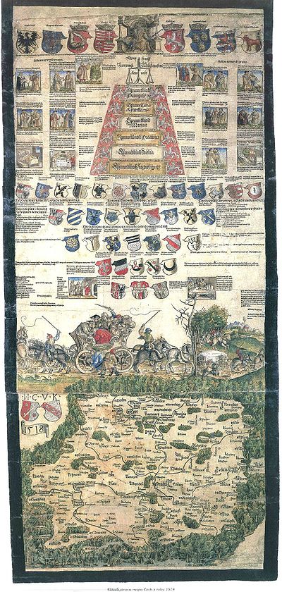
Klaudyán map of Bohemia
Encyclopedia
Bohemia
Bohemia is a historical region in central Europe, occupying the western two-thirds of the traditional Czech Lands. It is located in the contemporary Czech Republic with its capital in Prague...
(and earliest map to cover a country‘s area on a one sheet map ever). It was printed by Mikuláš Klaudyán
Mikuláš Klaudyán
Mikuláš Klaudyán was a physician and scholar in Mladá Boleslav, Bohemia and member of the Unity of the Brethren. He printed the oldest map of Bohemia . He was in close contact with printers in Nürnberg....
, a printer from Mladá Boleslav
Mladá Boleslav
Mladá Boleslav is a city in the Central Bohemian Region of the Czech Republic, on the left bank of the Jizera river about 50 km northeast of Prague.Founded in the second half of the 10th century by King Boleslav II as a royal castle...
. The ratio scale is 1:685000.
Description
The upper part consists of the picture of the King Louis II of Hungary and BohemiaLouis II of Hungary and Bohemia
Louis II was King of Hungary, Bohemia and Croatia from 1516 to 1526.- Early life :Louis was the son of Ladislaus II Jagiellon and his third wife, Anne de Foix....
with the emblems of his lands, the allegory of justice, coats of arms of highest Czech dignities and three important royal cities - Prague
Prague
Prague is the capital and largest city of the Czech Republic. Situated in the north-west of the country on the Vltava river, the city is home to about 1.3 million people, while its metropolitan area is estimated to have a population of over 2.3 million...
, Kutná Hora
Kutná Hora
Kutná Hora is a city in Bohemia, now the Czech Republic in the Central Bohemian Region.-History:The town began in 1142 with the settlement of the first Cistercian Monastery in Bohemia, Kloster Sedlitz, brought from the Imperial immediate Cistercian Waldsassen Abbey...
and Žatec
Žatec
Žatec is an old town in the Czech Republic, in Louny District, Ústí nad Labem Region. It has a population of 19,813 .The earliest historical reference to Sacz is in the Latin chronicle of Thietmar of Merseburg of 1004. During the 11th century it belonged to the Vršovci - a powerful Czech...
. In the middle of the map sheet is a picture symbolizing Czech religious disunion - a carriage drawn by horse couples to opposite directions. The map itself records about 280 towns and castles, and depicts also forests, mountains, rivers and roads.