
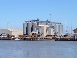
King's Lynn Docks
Encyclopedia
King’s Lynn Docks are located to the north of the town of King’s Lynn in the English
county
of Norfolk
. The Docks are 42.7 miles west southwest of Cromer
, 49.2 miles west of Norwich
and 105 miles north of London
. The Docks are on the A1078
Edward Benefer Way. The nearest railway station is the King’s Lynn
station on the Fen Line
which runs between King’s Lynn, Ely
and Cambridge
. The nearest airport is Norwich International Airport
.
England
England is a country that is part of the United Kingdom. It shares land borders with Scotland to the north and Wales to the west; the Irish Sea is to the north west, the Celtic Sea to the south west, with the North Sea to the east and the English Channel to the south separating it from continental...
county
County
A county is a jurisdiction of local government in certain modern nations. Historically in mainland Europe, the original French term, comté, and its equivalents in other languages denoted a jurisdiction under the sovereignty of a count A county is a jurisdiction of local government in certain...
of Norfolk
Norfolk
Norfolk is a low-lying county in the East of England. It has borders with Lincolnshire to the west, Cambridgeshire to the west and southwest and Suffolk to the south. Its northern and eastern boundaries are the North Sea coast and to the north-west the county is bordered by The Wash. The county...
. The Docks are 42.7 miles west southwest of Cromer
Cromer
Cromer is a coastal town and civil parish in north Norfolk, England. The local government authority is North Norfolk District Council, whose headquarters is in Holt Road in the town. The town is situated 23 miles north of the county town, Norwich, and is 4 miles east of Sheringham...
, 49.2 miles west of Norwich
Norwich
Norwich is a city in England. It is the regional administrative centre and county town of Norfolk. During the 11th century, Norwich was the largest city in England after London, and one of the most important places in the kingdom...
and 105 miles north of London
London
London is the capital city of :England and the :United Kingdom, the largest metropolitan area in the United Kingdom, and the largest urban zone in the European Union by most measures. Located on the River Thames, London has been a major settlement for two millennia, its history going back to its...
. The Docks are on the A1078
A1078 road
The A1082 is an English A road entirely in the county of Norfolk. It runs from a junction with the A148 King's Lynn to Cromer Road in the town of King's Lynn to a junction with the A148 King's Lynn to Cromer in the northern suburbs of King's Lynn...
Edward Benefer Way. The nearest railway station is the King’s Lynn
King's Lynn railway station
King's Lynn railway station serves the town of King's Lynn in Norfolk. The station is the terminus of the Fen Line from Cambridge, which is electrified at 25 kV AC overhead...
station on the Fen Line
Fen Line
The Fen Line is a railway in the United Kingdom that runs between the cities of Cambridge, Cambridgeshire and King's Lynn, Norfolk; the line is so called because it runs through The Fens. The line is part of the Network Rail Strategic Route 5 and comprises SRS 05.06 and part of 05.05...
which runs between King’s Lynn, Ely
Ely, Cambridgeshire
Ely is a cathedral city in Cambridgeshire, England, 14 miles north-northeast of Cambridge and about by road from London. It is built on a Lower Greensand island, which at a maximum elevation of is the highest land in the Fens...
and Cambridge
Cambridge
The city of Cambridge is a university town and the administrative centre of the county of Cambridgeshire, England. It lies in East Anglia about north of London. Cambridge is at the heart of the high-technology centre known as Silicon Fen – a play on Silicon Valley and the fens surrounding the...
. The nearest airport is Norwich International Airport
Norwich International Airport
Norwich International Airport , also known as Norwich Airport, is an airport in the City of Norwich within Norfolk, England north of the city centre and on the edge of the city's suburbs....
.
External links
- Port of King's Lynn official website