

Grão Mogol
Encyclopedia
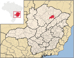
Minas Gerais
Minas Gerais is one of the 26 states of Brazil, of which it is the second most populous, the third richest, and the fourth largest in area. Minas Gerais is the Brazilian state with the largest number of Presidents of Brazil, the current one, Dilma Rousseff, being one of them. The capital is the...
. In 2007 the population was 14,954 in a total area of 3,890 km². The elevation is 829 meters. It became a municipality in 1840.
Location and Distances
Grão Mogol is located in an isolated area between Montes ClarosMontes Claros
Montes Claros is a city located in northern Minas Gerais state, in Brazil. The estimated population in 2010 was 412,284 inhabitants and the total area of the municipality was 3,470 km²...
and the Jequitinhonha River
Jequitinhonha River
thumb|Source of the river in [[Serro]]|rightThe Jequitinhonha River is a river that flows mainly through the Brazilian state of Minas Gerais. Its source lies near Diamantina in the Serra do Espinhaço at an elevation of 1,200 m, after which it flows northward and then east-northeastward across the...
. The distance to the state capital, Belo Horizonte
Belo Horizonte
Belo Horizonte is the capital of and largest city in the state of Minas Gerais, located in the southeastern region of Brazil. It is the third largest metropolitan area in the country...
, is 551 km. Other distances are: Brasília, 930; Montes Claros, 157; Rio de Janeiro, 1,080; Salvador, 894; and São Paulo, 1,215.
Grão Mogol is also an IBGE statistical microregion including the following municipalities: Botumirim
Botumirim
Botumirim is a Brazilian municipality located in the north of the state of Minas Gerais. In 2007 the population was 6,435 in a total area of 1,572 km². The elevation is 948 meters. It became a municipality in 1962.-Location and Distances:...
, Cristália
Cristália
Cristália is a Brazilian municipality located in the north of the state of Minas Gerais. In 2007 the population was 5,731 in a total area of 841 km². The elevation is 728 meters. It became a municipality in 1962.-Location and Distances:...
, Grão Mogol, Itacambira
Itacambira
Itacambira is a Brazilian municipality located in the north of the state of Minas Gerais. In 2007 the population was 5,018 in a total area of 1,788 km². It became a municipality in 1962.-Location and Distances:...
, Josenópolis
Josenópolis
Josenópolis is a Brazilian municipality located in the north of the state of Minas Gerais. In 2007 the population was 4,440 in a total area of 536 km². It became a municipality in 1997.-Location and Distances:...
, and Padre Carvalho
Padre Carvalho
Padre Carvalho is a Brazilian municipality located in the north of the state of Minas Gerais. In 2007 the population was 5,828 in a total area of 450 km². It became a municipality in 1997.-Location and Distances:...
. The population of this region was 39,406 in 2000 and the area was 9,108.00 km².
History
The settlement of Serra de Santo Antônio do Itacambiraçu, present-day Grão Mogol, had it origins in the discovery of diamonds at the end of the eighteenth century. In 1839 the place was called Arraial da Serra de Grão Mogol and soon began to attract people from all over the country including foreigners to search for diamonds.The site began to be noticed by the Portuguese crown for its commerce of diamonds and soon the government took over the mining and the commercialization. In 1840 what was only a "arraial" was made a "Vila Provincial" and in the same year it became a district.
In 1858, Grão Mogol received the category of city. For decades, it was considered the most important city in the north of the state of Minas Gerais. When the diamonds ran out the city began to lose population, especially after 1960, coinciding with the loss of territory to form the municipalities of Itacambira
Itacambira
Itacambira is a Brazilian municipality located in the north of the state of Minas Gerais. In 2007 the population was 5,018 in a total area of 1,788 km². It became a municipality in 1962.-Location and Distances:...
, Cristália
Cristália
Cristália is a Brazilian municipality located in the north of the state of Minas Gerais. In 2007 the population was 5,731 in a total area of 841 km². The elevation is 728 meters. It became a municipality in 1962.-Location and Distances:...
and Botumirim
Botumirim
Botumirim is a Brazilian municipality located in the north of the state of Minas Gerais. In 2007 the population was 6,435 in a total area of 1,572 km². The elevation is 948 meters. It became a municipality in 1962.-Location and Distances:...
.
Today the colonial buildings and the popular traditions make Grão Mogol an important touristic attraction.
Economic activities
The most important economic activities are cattle raising (19,000 head in 2006) and agriculture. The GDP in 2005 was R$ 50,489,000. The most important agricultural crops are bananas, coffee, tropical and citrus fruits, peanuts, rice, sugarcane, and corn. In the rural area there were 1,737 producers. The total area of agricultural land was 183,695 hectares in 2006. Pasture made up 56,000 ha. and 76,000 ha. were in woodland. In the urban area there was 1 banking agency in 2006.Health and education
This municipality is isolated from major population centers and suffers from drought and poor soils.- Municipal Human Development IndexHuman Development IndexThe Human Development Index is a composite statistic used to rank countries by level of "human development" and separate "very high human development", "high human development", "medium human development", and "low human development" countries...
: .672 (2000) - State ranking: 666 out of 853 municipalities as of 2000
- National ranking: 3,419 out of 5,138 municipalities as of 2000
- Degree of urbanization: 33.96% (2000)
- Infant mortality rate: 21.01 (2000) The rate for Minas Gerais was 17.40; the rate for Brazil was 18.91.
- Illiteracy rate: 29.03% (15 years old or older)(Data from 2000) The rate for Minas Gerais was 11.96; the rate for Brazil was 13.63
- Urban area covered by sewage system: 66.00%--the rate for Minas Gerais was 81.39%
- Health clinics, health centers, and hospitals: 3, 4, 1 with 56 beds