

Geographer's A–Z Street Atlas
Encyclopedia
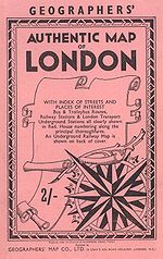
The A–Z or A to Zed, or in full the Geographers' A–Z Street Atlas, is a name given to any one of a range of atlases of streets in the United Kingdom
currently produced by Geographers' A-Z Map Company Limited. The first atlas, of London
, was originally compiled in the 1930s by Phyllis Pearsall
. The company she founded now publishes street map
s of many cities and towns in the UK.
 Until quite recently, the maps produced by the Geographers' (A-Z) Map Company did not list their publication date, so dating them can be quite hard. A few things that can help are:
One scheme is JIHGFEDCBA, for the numbers 1 through 9 and 0, so that HFD would be 357, or March 1957. This seems to be used on all of their maps not in book form (it may be used in the book form ones, but that has not been confirmed).
came to write the first edition covering London
was featured in a 2005 episode of Nicholas Crane
's Map Man
TV programme. This programme revealed the interesting information that on all their maps A-Z print a non-existent trap street
so that they can tell if a map has been illegally copied from theirs, a technique used by several publishers of reference works (see fictitious entry
).
United Kingdom
The United Kingdom of Great Britain and Northern IrelandIn the United Kingdom and Dependencies, other languages have been officially recognised as legitimate autochthonous languages under the European Charter for Regional or Minority Languages...
currently produced by Geographers' A-Z Map Company Limited. The first atlas, of London
London
London is the capital city of :England and the :United Kingdom, the largest metropolitan area in the United Kingdom, and the largest urban zone in the European Union by most measures. Located on the River Thames, London has been a major settlement for two millennia, its history going back to its...
, was originally compiled in the 1930s by Phyllis Pearsall
Phyllis Pearsall
Phyllis Pearsall, MBE was a painter and writer, and the creator of the A to Z map of London.-Early years:She was born Phyllis Isobella Gross in East Dulwich, London on 25 September 1906...
. The company she founded now publishes street map
Street map
A street map is a map showing roads and streets in a district or entire city. Street maps are great tools for navigating cities, towns or communities. They are available in printed forms, online on the Internet or on mobile phones with GPRS connection....
s of many cities and towns in the UK.
Dating old maps
- Their first map was published in 1936
- There were no maps produced by them during WW2 (1939-1945)
- Until 1962, the "Published By" address was 24 Grays Inn Road, Holborn, London
- From 1962 to 1992, the "Published By" address was Sevenoaks, Kent
- From 1992 onwards, the "Published By" address is Borough Green, Kent
- In 1972, the company name was changed from Geographers' Map Company to Geographers' A-Z Map Company
Cartographic date
On all their maps, there is a 3 or 4 letter code in one of the corners, often the one containing the key. These letters represent numbers, which are the cartographic date, in the form (M)MYY. There is at least one scheme in use, but possibly also a second.One scheme is JIHGFEDCBA, for the numbers 1 through 9 and 0, so that HFD would be 357, or March 1957. This seems to be used on all of their maps not in book form (it may be used in the book form ones, but that has not been confirmed).
Media appearance
The Geographer's A–Z Street Atlas and the story of how Phyllis PearsallPhyllis Pearsall
Phyllis Pearsall, MBE was a painter and writer, and the creator of the A to Z map of London.-Early years:She was born Phyllis Isobella Gross in East Dulwich, London on 25 September 1906...
came to write the first edition covering London
London
London is the capital city of :England and the :United Kingdom, the largest metropolitan area in the United Kingdom, and the largest urban zone in the European Union by most measures. Located on the River Thames, London has been a major settlement for two millennia, its history going back to its...
was featured in a 2005 episode of Nicholas Crane
Nicholas Crane
Nicholas Crane is an English geographer, explorer, writer and broadcaster. Since 2004, he has written and presented four notable television series for BBC Two: Coast, Great British Journeys, Map Man and Town....
's Map Man
Map Man
Map Man is a BBC documentary series first broadcast on BBC Two in 2004. Each episode recounts a particular tale in the history of British cartography, with a particular emphasis on the individuals whose dedication and ingenuity led to the production of some of history's most ground-breaking...
TV programme. This programme revealed the interesting information that on all their maps A-Z print a non-existent trap street
Trap street
A trap street is a fictitious entry in the form of a misrepresented street on a map, often outside the area the map nominally covers, for the purpose of "trapping" potential copyright violators of the map, who will be unable to justify the inclusion of the "trap street" on their map...
so that they can tell if a map has been illegally copied from theirs, a technique used by several publishers of reference works (see fictitious entry
Fictitious entry
Fictitious entries, also known as fake entries, Mountweazels, ghost word and nihil articles, are deliberately incorrect entries or articles in reference works such as dictionaries, encyclopedias, maps, and directories. Entries in reference works normally originate from a reliable external source,...
).