

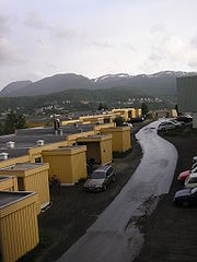
Gangsås
Encyclopedia

Harstad
is the second largest city and municipality by population, in Troms county, Norway – the city is also the third largest in North Norway. Thus Harstad is the natural centre for its district. Situated approximately north of the Arctic Circle, the city celebrated its 100th anniversary in...
city in the county of Troms
Troms
or Romsa is a county in North Norway, bordering Finnmark to the northeast and Nordland in the southwest. To the south is Norrbotten Län in Sweden and further southeast is a shorter border with Lapland Province in Finland. To the west is the Norwegian Sea...
, Norway
Norway
Norway , officially the Kingdom of Norway, is a Nordic unitary constitutional monarchy whose territory comprises the western portion of the Scandinavian Peninsula, Jan Mayen, and the Arctic archipelago of Svalbard and Bouvet Island. Norway has a total area of and a population of about 4.9 million...
– situated southeast of the city center. It is bounded by Stangnes
Stangnes
Stangnes is part of the city of Harstad in Troms county, Norway. It is located south-east of the city center, bordered by Gangsåstoppen and Åsby to the west, Kanebogen to the south-west and the fjord Vågsfjorden to the north and east...
to the east, Åsby and Kanebogen
Kanebogen
Kanebogen is a part of the city of Harstad in Troms county, Norway. It is located about south of the city center – south of Gangsås, southwest of Stangnes, north of Medkila and southeast of Grønnebakkan....
to the south and the fjord Vågsfjorden
Vågsfjorden
Vågsfjorden is a fjord in the southern part of Troms county in North Norway. Situated between Norway's two largest islands, Hinnøya to the south and Senja to the north, the 46 kilometers long fjord is part of the municipalities of Harstad, Bjarkøy, Tranøy, Dyrøy, Ibestad and Skånland...
to the northwest.
The main neighbourhoods on Gangsås are Vollen, inhabited in 1975, and Øvre Gangsås (Upper Gangsås), established in the 1980s. At the western foot of the hill is Mercur; some people live there, but the area is mostly industrialized, not least by Statoil
Statoil
Statoil ASA is a Norwegian petroleum company established in 1972. It merged with Norsk Hydro in 2007 and was known as StatoilHydro until 2009, when the name was changed back to Statoil ASA. The brand Statoil was retained as a chain of fuel stations owned by StatoilHydro...
.
The latter part of the name Gangsås – ås – means hill. From the top of the hill, Gangsåstoppen, which is uninhabited and approximately 180 meters above sea level, one has the best view of the city (towards west) and the surrounding areas, including the hills Middagsfjellet and Hinnstein. To the east one sees Rolla
Rolla (Troms)
Rolla is an island in the municipality of Ibestad in Troms county, Norway. It has an area of . The highest point is Drangen at a height of . The population on Rolla is 1,078....
and the mainland, to the south Tjeldsundet
Tjeldsundet
Tjeldsundet is the sound or strait that is located between the island Hinnøya and mainland Norway in the northern part, and in the southern part it is between Hinnøya and Tjeldøya island...
and to the north Grytøya
Grytøya
Grytøya is an island situated just north of Hinnøya and south of Bjarkøya in Northern Norway. It belongs to the municipalities of Harstad and Bjarkøy in Troms county, Norway. It is surrounded by the Vågsfjorden and the Andsfjorden. The island has an area of , and the highest peak is Nona at ...
and Senja
Senja
Senja is the second largest island in Norway . It is located along the Troms county coastline with Finnsnes as the closest town. Senja is connected to the mainland by the Gisund Bridge. The municipalities located on Senja are Lenvik , Berg, Torsken, and Tranøy...
.
A marked path leeds to Gangsåstoppen, which is visited by 30–40 people every day in average, from the car park at the end of the road Toppenveien. The trip takes about 20 minutes, and there is a mail box at the top where one will be required to sign the guest book.
