
Fort Street-Pleasant Street and Norfolk & Western Railroad Viaduct
Encyclopedia
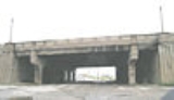
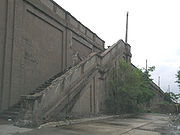
The Fort Street—Pleasant Street and Norfolk & Western Railroad Viaduct is a bridge carrying six lanes of Fort Street
over both Pleasant Street and four tracks of Norfolk Southern Railway
's Michigan Line in Detroit, Michigan
, just west of the Rouge River
. It was listed on the National Register of Historic Places
in 2000. It is currently closed to road traffic due to construction.
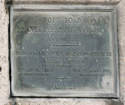
In the 1920s, Fort Road was one of the roads chosen for upgrade to a "superhighway." These roads were upgraded by the city, county and state to feature 204 feet (62.2 m) right-of-ways, central medians, and nighttime lighting. Additionally, with the growth in vehicular traffic in the early 20th century, railroad-highway intersections increasingly became sources of both travel delays and accidents. On 1928, the Wayne County Road Commission and the Michigan State Highway Department announced plans to separate rail and vehicle grades, with railways contributing substantially to the cost. The Fort Road bridge project was the first to be undertaken.
However, the project had substantial design considerations, resulting in a large cost and a lengthy planning process. The bridge was required to be long enough to permit passage of both two city streets and twelve railroad tracks at an oblique angle; it had to be wide enough to accommodate two 40 feet (12.2 m) paved traffic surfaces for the Fort Superhighway. Construction finally began in summer 1928, and the structure was completed in 1930.
The resulting structure, according to a Wayne County Road Commission at the time, included an "ornamental concrete handrail" supporting "ornamental concrete lamp posts" so that "the entire project will be adequately and beautifully lighted." In subsequent years, the urn-shaped balusters of the original railing have been replaced by solid concrete panels. However, the other components of the railings, including the octagonal lamp posts, remain intact. The loss of the balusters is unfortunate, but the overall scale and significance of the bridge outweighs the minor loss.
M-85 (Michigan highway)
M-85, also known as Fort Street or Fort Road for its entire length, is a state highway route in the U.S. state of Michigan.In Detroit proper, M-85 consists of West Fort street and South Fort street...
over both Pleasant Street and four tracks of Norfolk Southern Railway
Norfolk Southern Railway
The Norfolk Southern Railway is a Class I railroad in the United States, owned by the Norfolk Southern Corporation. With headquarters in Norfolk, Virginia, the company operates 21,500 route miles in 22 eastern states, the District of Columbia and the province of Ontario, Canada...
's Michigan Line in Detroit, Michigan
Michigan
Michigan is a U.S. state located in the Great Lakes Region of the United States of America. The name Michigan is the French form of the Ojibwa word mishigamaa, meaning "large water" or "large lake"....
, just west of the Rouge River
River Rouge (Michigan)
The River Rouge, also known as the Rouge River, is a river in the Metro Detroit area of southeastern Michigan. It flows into the Detroit River at Zug Island, which is the boundary between the cities of River Rouge and Detroit....
. It was listed on the National Register of Historic Places
National Register of Historic Places
The National Register of Historic Places is the United States government's official list of districts, sites, buildings, structures, and objects deemed worthy of preservation...
in 2000. It is currently closed to road traffic due to construction.
History
The area along the Fort Street corridor near Pleasant Street was transformed early in the 20th century from a residential community to a substantially industrial center. An undated newspaper clipping from the time on the "passing of Fort Street West" laments, "[o]nce a social center, it is now a great business artery whose splendid mansions have given way before the march of industrial progress." Among other industrial centers in the area, the Ford River Rouge Complex is just upstream from the Fort Road (as it was named at the time) river crossing, making both Fort Road and the Norfolk & Western tracks main transportation arteries in Detroit.In the 1920s, Fort Road was one of the roads chosen for upgrade to a "superhighway." These roads were upgraded by the city, county and state to feature 204 feet (62.2 m) right-of-ways, central medians, and nighttime lighting. Additionally, with the growth in vehicular traffic in the early 20th century, railroad-highway intersections increasingly became sources of both travel delays and accidents. On 1928, the Wayne County Road Commission and the Michigan State Highway Department announced plans to separate rail and vehicle grades, with railways contributing substantially to the cost. The Fort Road bridge project was the first to be undertaken.
However, the project had substantial design considerations, resulting in a large cost and a lengthy planning process. The bridge was required to be long enough to permit passage of both two city streets and twelve railroad tracks at an oblique angle; it had to be wide enough to accommodate two 40 feet (12.2 m) paved traffic surfaces for the Fort Superhighway. Construction finally began in summer 1928, and the structure was completed in 1930.
The resulting structure, according to a Wayne County Road Commission at the time, included an "ornamental concrete handrail" supporting "ornamental concrete lamp posts" so that "the entire project will be adequately and beautifully lighted." In subsequent years, the urn-shaped balusters of the original railing have been replaced by solid concrete panels. However, the other components of the railings, including the octagonal lamp posts, remain intact. The loss of the balusters is unfortunate, but the overall scale and significance of the bridge outweighs the minor loss.
Significance
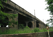
The Fort Street Viaduct is noteworthy for both its design and size. It was normally cheaper to build a rail road bridge over the street rather than the other way around. However, the large number of tracks at the Fort Road crossing would have required a substantial subway. The Fort Street Viaduct, which stretches 2800 feet (853.4 m) in length and includes an 80 feet (24.4 m) roadway, was by far the largest and most ambitious structure included in the 1920s grade separation plan. This bridge exemplifies the importance attached to the grade separation program, as planners tried to increase vehicle safety and decrease congestion.External links
- Fort Street Viaduct from HistoricBridges.org: multiple photographs.