
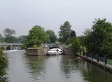
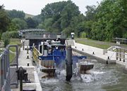
Day's Lock
Encyclopedia
Day's Lock is a lock on the River Thames
near Dorchester-on-Thames, Oxfordshire
, England
on the Dorchester side of the river.
The pound lock was built in 1789 by the Thames Navigation Commissioner. The lock is across the river from the small village of Little Wittenham
and is overlooked from the south by the hills of Wittenham Clumps
, with a particularly good view from Round Hill.
The weir runs straight across the river from the other side of the lock island.
Day's Lock is the main gauging station for the measurement of the water flow in the River Thames.
The World Poohsticks
Championships, on behalf of the RNLI
, have taken place annually here since 1983.
here. The pound lock was staked out in August 1788. It was judged best to build it on the Oxfordshire bank provided the existing weir owner would "remove his buck
s"(eel traps). In 1865 it was reported to be in utter ruin and dangerous, but reconstruction did not take place until 1871. In 1882 a bell push to summon the keeper was installed, there being no lock keeper's house at that time. The lock house was not built until 1928 when it was erected on Lock House Island next to Little Wittenham Bridge.
which spans the river in two sections with an island between. Using this, the lock is a short walk from Little Wittenham where is a car park near St Peter's Church. The lock is a little further to walk to from Dorchester.
 On the eastern bank to the north-east is the historic town of Dorchester
with its ancient Abbey
. The river follows a long bend round to Clifton Hampden
. Here it goes under Clifton Hampden Bridge
and past the historic Barley Mow public house, as mentioned in the book, Three Men in a Boat
. Before Clifton Lock, the old stream separates, leading to Long Wittenham
.
There are navigation transit markers
upstream of the lock to allow boats to check their speed. A powered boat should take more than one minute to pass between the markers.
The Thames Path
follows the western/southern bank to Clifton Hampden Bridge, where it crosses to the opposite northern bank to continue to Clifton Lock.
River Thames
The River Thames flows through southern England. It is the longest river entirely in England and the second longest in the United Kingdom. While it is best known because its lower reaches flow through central London, the river flows alongside several other towns and cities, including Oxford,...
near Dorchester-on-Thames, Oxfordshire
Oxfordshire
Oxfordshire is a county in the South East region of England, bordering on Warwickshire and Northamptonshire , Buckinghamshire , Berkshire , Wiltshire and Gloucestershire ....
, England
England
England is a country that is part of the United Kingdom. It shares land borders with Scotland to the north and Wales to the west; the Irish Sea is to the north west, the Celtic Sea to the south west, with the North Sea to the east and the English Channel to the south separating it from continental...
on the Dorchester side of the river.
The pound lock was built in 1789 by the Thames Navigation Commissioner. The lock is across the river from the small village of Little Wittenham
Little Wittenham
Little Wittenham is a village and civil parish on the south bank of the River Thames, northeast of Didcot in South Oxfordshire. It has one of only 220 habitats across Europe which is designated as a Special Area of Conservation under the European Union's Habitats Directive , on the Conservation of...
and is overlooked from the south by the hills of Wittenham Clumps
Wittenham Clumps
Wittenham Clumps is the commonly used name for a set of small hills in the flat Thames Valley, in the civil parish of Little Wittenham in the English county of Oxfordshire....
, with a particularly good view from Round Hill.
The weir runs straight across the river from the other side of the lock island.
Day's Lock is the main gauging station for the measurement of the water flow in the River Thames.
The World Poohsticks
Poohsticks
Poohsticks is a game first mentioned in The House at Pooh Corner, a Winnie-the-Pooh book by A. A. Milne. It is a simple game which may be played on any bridge over running water; each player drops a stick on the upstream side of a bridge and the one whose stick first appears on the downstream side...
Championships, on behalf of the RNLI
Royal National Lifeboat Institution
The Royal National Lifeboat Institution is a charity that saves lives at sea around the coasts of Great Britain, Ireland, the Channel Islands and the Isle of Man, as well as on selected inland waterways....
, have taken place annually here since 1983.
History
The name Day's Lock comes from the Day family, local Catholic yeomen since the 17th century. During the 16th century, there was a flash lockFlash lock
Early locks were designed with a single gate, known as a flash lock or staunch lock. The earliest European references to what were clearly flash locks were in Roman times....
here. The pound lock was staked out in August 1788. It was judged best to build it on the Oxfordshire bank provided the existing weir owner would "remove his buck
Eel buck
Eel bucks are a type of fish trap that was prevalent in the River Thames in England up to the 20th century. It was used particularly to catch eels which were a staple part of the London diet....
s"(eel traps). In 1865 it was reported to be in utter ruin and dangerous, but reconstruction did not take place until 1871. In 1882 a bell push to summon the keeper was installed, there being no lock keeper's house at that time. The lock house was not built until 1928 when it was erected on Lock House Island next to Little Wittenham Bridge.
Access to the lock
A short way downstream of the lock is Little Wittenham BridgeLittle Wittenham Bridge
Little Wittenham Bridge is a footbridge across the River Thames in England near Dorchester-on-Thames, Oxfordshire. It is just downstream of Day's Lock on the reach above Benson Lock and connects Little Wittenham to Dorchester....
which spans the river in two sections with an island between. Using this, the lock is a short walk from Little Wittenham where is a car park near St Peter's Church. The lock is a little further to walk to from Dorchester.
Reach above the lock
Dorchester, Oxfordshire
Dorchester-on-Thames is a village and civil parish on the River Thame in Oxfordshire, about northwest of Wallingford and southeast of Oxford. Despite its name, Dorchester is not on the River Thames, but just above the Thame's confluence with it...
with its ancient Abbey
Dorchester Abbey
Dorchester Abbey is a Church of England parish church in Dorchester on Thames, Oxfordshire, about southeast of Oxford. It was formerly a Norman abbey church and was built on the site of a Saxon cathedral.-History:...
. The river follows a long bend round to Clifton Hampden
Clifton Hampden
Clifton Hampden is a village and civil parish on the north bank of the River Thames, just over east of Abingdon in Oxfordshire. Since 1932 the civil parish has included the village of Burcot, east of Clifton Hampden.-Manor:...
. Here it goes under Clifton Hampden Bridge
Clifton Hampden Bridge
Clifton Hampden Bridge is a road bridge crossing the River Thames in Clifton Hampden, Oxfordshire, England, situated on the reach below Clifton Lock. Originally it joined Oxfordshire on the north bank with Berkshire on the south but in 1974 the area on the south bank was transferred from Berkshire...
and past the historic Barley Mow public house, as mentioned in the book, Three Men in a Boat
Three Men in a Boat
Three Men in a Boat ,The Penguin edition punctuates the title differently: Three Men in a Boat: To Say Nothing of the Dog! published in 1889, is a humorous account by Jerome K...
. Before Clifton Lock, the old stream separates, leading to Long Wittenham
Long Wittenham
Long Wittenham is a village and civil parish north of Didcot, and southeast of Abingdon. It was part of Berkshire until the 1974 boundary changes transferred it from Berkshire to Oxfordshire, and from the former Wallingford Rural District to the new district of South Oxfordshire.It used to be...
.
There are navigation transit markers
Navigation transit markers
Navigation Transit Markers are posts placed alongside a navigation to allow powered craft to check their speed. There are examples along the River Thames in England....
upstream of the lock to allow boats to check their speed. A powered boat should take more than one minute to pass between the markers.
The Thames Path
Thames Path
The Thames Path is a National Trail, opened in 1996, following the length of the River Thames from its source near Kemble in Gloucestershire to the Thames Barrier at Charlton. It is about long....
follows the western/southern bank to Clifton Hampden Bridge, where it crosses to the opposite northern bank to continue to Clifton Lock.
See also
- Locks on the River ThamesLocks on the River ThamesThe English River Thames is navigable from Cricklade or Lechlade to the sea, and this part of the river falls 71 metres . There are 45 locks on the river, each with one or more adjacent weirs...