
Belén, Honduras
Encyclopedia
Belén is a municipality
in the Honduran
department of Lempira
. The latitude is 15.75 north, the longitude is 87.93 west, and the altitude is 313 meters.
 Belén is one of the municipalities of the Lempira department. It is located south east from the colonial city of Gracias, following the paved road heading to the Intibuca department. The first big town in Intibuca is called San Juan (del Caite). In order to make it to the center of the town, it is necessary to take a turn off at approximately 24 km from Gracias and then 3 km to the town. The paved road ends at the boundary of the Lempira and Intibuca departments. Currently, the government is still working on a road that was supposed to be finished 5 years ago.
to improve the quality of life for the poor.
The main town and the majority of the villages have electricity. In 2007 the mayor's office started the installation of sewer systems in the main town of Belén. Since Belén is near the larger town of Gracias, it does not have any hotels or hostels.
Municipality
A municipality is essentially an urban administrative division having corporate status and usually powers of self-government. It can also be used to mean the governing body of a municipality. A municipality is a general-purpose administrative subdivision, as opposed to a special-purpose district...
in the Honduran
Honduras
Honduras is a republic in Central America. It was previously known as Spanish Honduras to differentiate it from British Honduras, which became the modern-day state of Belize...
department of Lempira
Lempira (department)
Lempira is one of the 18 departments of Honduras Central America, located in the western part of the country with borders with El Salvador. It was named Gracias department until 1943, and the departmental capital is Gracias....
. The latitude is 15.75 north, the longitude is 87.93 west, and the altitude is 313 meters.
History
Belén was established as a municipality in 1871, according to old documents that are now kept in the mayor's office. The origin of its first settlers is uncertain, but it is believed that they were descendants of "Chorti" Indians, natives of the western part of the country. First known as "Curincunque", Belén appeared in the census of 1791, as part of the "Curato" of Gracias a Dios and in the national division of 1889 as part of Gracias district.Geography
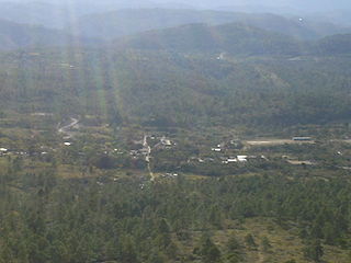
Due to many pine forests all around the town and and surrounding villages, locals enjoy very temperate weather throughout the year, except for the summer (dry) season from February through June. These forests also contain oak trees, but on a smaller scale. The forests, irregular hills and mountains around Belén provide many inspiring landscapes for both locals and tourists.Boundaries
Its boundaries are:- North: La IgualaLa IgualaLa Iguala is a municipality in the Honduran department of Lempira.La Iguala is one of the oldest municipalities of the Lempira department. The municipality capital is also known as "La Iguala Centro". The access to this town is quite a challenge. Both ways will be briefly described here...
and GraciasGraciasGracias is a small Honduran town/municipality that was founded in 1536, and has a population of approximately 25,000 people... - South: Intibucá Department
- East: Intibucá Department
- West: La CampaLa CampaLa Campa is a municipality and an aldea, or small town, in the Honduran Department of Lempira, located about by dirt road from Gracias, the largest town in the immediate region. The inhabitants of Gracias, La Campa, and other nearby aldeas, including San Manuel Colohete, are mainly of Lenca descent...
- Surface Extents: 198 km²
Resources
The main crops are corn, beans, and coffee. The government provides resources in order to improve the well-being of the people. Also, there are an important contributions from organizations such as World VisionWorld Vision
World Vision, founded in the USA in 1950, is an evangelical relief and development organization whose stated goal is "to follow our Lord and Saviour Jesus Christ in working with the poor and oppressed to promote human transformation, seek justice and bear witness to the good news of the Kingdom of...
to improve the quality of life for the poor.
The main town and the majority of the villages have electricity. In 2007 the mayor's office started the installation of sewer systems in the main town of Belén. Since Belén is near the larger town of Gracias, it does not have any hotels or hostels.
Population
- Population: The figure was 4,444 in 2001. This was used to elaborate an estimate by the INE Honduras (NSI National Statistics Institute), so in 2008 the population might be 5,728.
- Villages: 5
- Settlement: 51
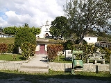
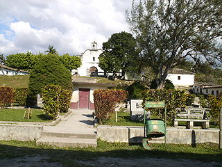
Tourism
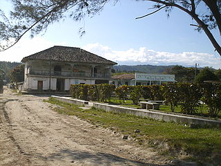
As seen in the photos on this article, this town has the typical colonial distribution. Some old buildings made of adobe can be seen, but they are not preserved, with the exception of the old colonial church. There are no hostels or a places to stay, but that is not a problem because the city of Gracias and its many hotels are available.- Local Holidays: "Virgen del Rosario" day on October 8.