

Amblève (river)
Encyclopedia
German language
German is a West Germanic language, related to and classified alongside English and Dutch. With an estimated 90 – 98 million native speakers, German is one of the world's major languages and is the most widely-spoken first language in the European Union....
) is a 93 km long river in eastern Belgium
Belgium
Belgium , officially the Kingdom of Belgium, is a federal state in Western Europe. It is a founding member of the European Union and hosts the EU's headquarters, and those of several other major international organisations such as NATO.Belgium is also a member of, or affiliated to, many...
in the province of Liège
Liège (province)
Liège is the easternmost province of Belgium and belongs to the Walloon Region. It is an area of French and German ethnicity. It borders on the Netherlands, Germany, Luxembourg, and in Belgium the provinces of Luxembourg, Namur, Walloon Brabant , and those of Flemish Brabant and Limburg . Its...
. It is a right tributary of the river Ourthe
Ourthe
The Ourthe is a 165 km long river in the Ardennes in Wallonia . It is a right tributary to the river Meuse. The Ourthe is formed at the confluence of the Ourthe Occidentale and the Ourthe Orientale , west of Houffalize.The source of the Ourthe Occidentale is near Libramont-Chevigny, in the...
. It rises near Büllingen
Büllingen
Büllingen is a largely German language-speaking municipality located in the Belgian province of Liège. On January 1, 2006 Büllingen had a total population of 5,385. The total area is 150.49 km² which gives a population density of 36 inhabitants per km²....
in the High Fens
High Fens
The High Fens , which were declared a nature reserve in 1957, are an upland area, a plateau region in the province of Liège, in the east of Belgium and nearby parts of Germany, lying between the Ardennes and the Eifel highlands. It is the largest nature reserve or park in Belgium, with an area of ;...
("Hoge Venen",Hohes Venn, Hautes Fagnes), close to the border with Germany
Germany
Germany , officially the Federal Republic of Germany , is a federal parliamentary republic in Europe. The country consists of 16 states while the capital and largest city is Berlin. Germany covers an area of 357,021 km2 and has a largely temperate seasonal climate...
.
Tributaries of the Amblève are the rivers Warche
Warche
The Warche is a river in eastern Belgium .From its source at Losheimergraben on the Belgian-German border, it flows roughly west about 50 km, across the south of the Hautes Fagnes region....
, Eau Rouge
Eau Rouge
The Eau Rouge is a small, 15 km long stream in the Belgian province of Liège, right tributary of the Amblève. It starts in the Hautes Fagnes and ends in Challes, near Stavelot in the river Amblève....
, Salm
Salm River (Belgium)
The Salm is a river in eastern Belgium , left tributary to the river Amblève. Its source is in the Ardennes, close to the border with Luxembourg near Bovigny. The Salm flows through the municipalities Gouvy, Vielsalm and Trois-Ponts, where it joins the river Amblève. It was also fought over in...
and Lienne
Lienne
Lienne is a river of Belgium. It flows for 28 kilometres through the province of Liège in the northern-central part of the country....
. The Amblève flows through the towns of Amel
Amel
Amel is a Belgian municipality in the Walloon province of Liège, and is part of the German-speaking Community of Belgium .On January 1, 2006 Amel had a total population of 5,282...
, Stavelot
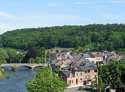
Stavelot
Stavelot is a Walloon municipality located in the Belgian province of Liège. On January 1, 2006, Stavelot had a total population of 6,671. The total area is 85.07 km² which gives a population density of 78 inhabitants per km².-History:...
, Trois-Ponts
Trois-Ponts
Trois-Ponts is a municipality of Belgium. It lies in the country's Walloon Region and Province of Liege. On January 1, 2006 Trois-Ponts had a total population of 2,445. The total area is 68.90 km² which gives a population density of 35 inhabitants per km². It is situated at the confluence of the...
, Remouchamps, and Aywaille
Aywaille
Aywaille is a Belgian municipality located in the Walloon province of Liège. On January 1, 2006 Aywaille had a total population of 10,910. The total area is 79.97 km² which gives a population density of 136 inhabitants per km². The inhabitants of Aywaille are called the "Aqualiens"...
. The Amblève joins the river Ourthe
Ourthe
The Ourthe is a 165 km long river in the Ardennes in Wallonia . It is a right tributary to the river Meuse. The Ourthe is formed at the confluence of the Ourthe Occidentale and the Ourthe Orientale , west of Houffalize.The source of the Ourthe Occidentale is near Libramont-Chevigny, in the...
in Comblain-au-Pont
Comblain-au-Pont
Comblain-au-Pont is a Walloon municipality located in the Belgian province of Liège. On January 1, 2006 Comblain-au-Pont had a total population of 5,372. The total area is 22.68 km² which gives a population density of 237 inhabitants per km². It is situated at the confluence of the rivers...
.
Sites
At the village of Coo (near Trois-Ponts) is the Coo Waterfall, which at 15 meters tall is not the highest but one of the better known waterfalls in BelgiumBelgium
Belgium , officially the Kingdom of Belgium, is a federal state in Western Europe. It is a founding member of the European Union and hosts the EU's headquarters, and those of several other major international organisations such as NATO.Belgium is also a member of, or affiliated to, many...
. The waterfall was created artificially in the 18th century when local monks cut through a bend in the river to feed a watermill. The dried out river bed is now used as the lower storage basin for the Coo hydro-electric power plant.
A curiosity of Lorcé, a nearby village, is the unusual design of the dam located at a place called "Fang-Naze" or "Fagne-Naze." Built between 1928 and 1932, it captures about 50,000 m³ of water which is then led through a 3,460 meter long tunnel cut out of the hill, before falling 40 meters into the turbines of the power plant "Heid Ile" located at Nonceveux part of Aywaille
Aywaille
Aywaille is a Belgian municipality located in the Walloon province of Liège. On January 1, 2006 Aywaille had a total population of 10,910. The total area is 79.97 km² which gives a population density of 136 inhabitants per km². The inhabitants of Aywaille are called the "Aqualiens"...
.
On the right bank near Sprimont
Sprimont
Sprimont is a municipality of Belgium. It lies in the country's Walloon Region and Province of Liege. On January 1, 2006 Sprimont had a total population of 12,782. The total area is 74.28 km² which gives a population density of 172 inhabitants per km²....
is the site of the Belle Roche cave, the oldest known place of human occupation of the Benelux
Benelux
The Benelux is an economic union in Western Europe comprising three neighbouring countries, Belgium, the Netherlands, and Luxembourg. These countries are located in northwestern Europe between France and Germany...
(dating back about 500,000 years).
The "Fond de Quareux" stretch of the river near Nonceveux is listed as one of Wallonia's Major Heritage sites.