Aburrá Valley
Encyclopedia

Medellín river
The Medellín River , called Porce River during most of its course, is a river that flows though the Colombian city of Medellín and its metropolitan area...
and one of the most populous valleys of Colombia
Colombia
Colombia, officially the Republic of Colombia , is a unitary constitutional republic comprising thirty-two departments. The country is located in northwestern South America, bordered to the east by Venezuela and Brazil; to the south by Ecuador and Peru; to the north by the Caribbean Sea; to the...
in its Andean Region
Andean Region of Colombia
The Andes mountains form the most populated region of Colombia and contain the majority of the country's urban centres. They were also the location of the most significant pre-Columbian indigenous settlement...
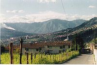
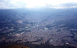
with near 3 million inhabitants. The valley is located on the Central Range, over the Antioquian Mountain just between the Magdalean and Cauca valleys from east to west. The name "Aburrá" comes from an ancient language spoken in the place by the "Aburreans" (Aburraes) before the Spaniards settled the place during the 16th century.
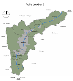
The valley is oriented from south to north being the south the highest level and the north the low level. The altitudes of the mountains around the valley (west and east mountains), can reach up to 2,800 meters above the sea level. The lowest level is 1,300 meters above the sea level. From its north natural limit to its southern part, the valley is 60 kilometers long, while there are several varieties in its wide, being the wider part the one that corresponds to the municipality of Medellín
Medellín
Medellín , officially the Municipio de Medellín or Municipality of Medellín, is the second largest city in Colombia. It is in the Aburrá Valley, one of the more northerly of the Andes in South America. It has a population of 2.3 million...
with 80 to 90 kilometers and the narrowest the part that corresponds to the municipality of Copacabana
Copacabana, Antioquia
Copacabana is a town and municipality in the Colombian department of Antioquia. Copacabana is part of the Metropolitan Area of Medellín....
with 30 kilometers.

Aborigins
There are archaeological evidences of human settlements in the Aburrá Valley since 10,500 years by hunters and collectors. The Spaniard conquers of the Valley found groups like Aburrá, Yamesí, Pequé, Ebejico, Norisco and Maní that were in the Valley since about the 5th century. The Aburrá people gave the name to the Valley. They lived from agriculture (maize, beans and cotton), textile weaving and decoration, commercialization of salt and goldsmith. Under the Spaniard rule they lost the possession of the land and were located in mines and feudalist systems. Sickness brought by the Europeans, the heavy work and mistreatments caused their extinction, at least from the Valley. Descendants and peoples related to the Aburrá Valley ancient ancestors could be found today in other regions of the Antioquia State like UrabáUrabá Antioquia
Urabá Antioquia is a subregion in the Colombian Department of Antioquia. The region is made up by 24 municipalities. Most of this region northern portion is part of the Colombian Caribbean Region bordering the Caribbean sea.-Municipalities:* Apartadó...
and the West and South regions.
The Spaniard discovering of the Valley

Marshal
Marshal , is a word used in several official titles of various branches of society. The word is an ancient loan word from Old French, cf...
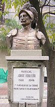
Jorge Robledo was in what is today Heliconia
Heliconia, Antioquia
Heliconia is a town and municipality in Antioquia Department, Colombia....
, when he saw at the distant what he thought was a valley. He sent Jerónimo Luis Tejelo to explore the territory and Tejelo arrived during the night of August 23 to a plain field. The Spaniards gave the name of Valley of Saint Bartholomew that was to be changed for the Aboriginal one of Aburrá that is translated as the "Painters" due to the textile decorations of the natives. However, the conquerors did not feel attracted by the valley due to the lack of wealth and the bellicosity of the aborigines.
In 1574 Gaspar de Rodas asked to the Antioquia's Cabildo
Cabildo (council)
For a discussion of the contemporary Spanish and Latin American cabildo, see Ayuntamiento.A cabildo or ayuntamiento was a former Spanish, colonial administrative council that governed a municipality. Cabildos were sometimes appointed, sometimes elected, but were considered to be representative of...
four miles of land to establish herds and food stays in the valley. The Cabildo granted three miles.
In 1616 the Colonial Visitor Francisco de Herrera y Campuzano founded a settlement with 80 aborigines naming it "Poblado de San Lorenzo" in what is today "El Poblado Square". In 1646 a racist Colonial law ordered the separation of aborigines from mestizo
Mestizo
Mestizo is a term traditionally used in Latin America, Philippines and Spain for people of mixed European and Native American heritage or descent...
s and mulatto
Mulatto
Mulatto denotes a person with one white parent and one black parent, or more broadly, a person of mixed black and white ancestry. Contemporary usage of the term varies greatly, and the broader sense of the term makes its application rather subjective, as not all people of mixed white and black...
s and for this reason the colonial administration began the construction of a new town in Aná, where is today the Berrio Square and where it was built a place called Nuestra Señora de la Candelaria de Aná (Our Lady of Candelaria of Aná). Three years after they started the construction of the Minor Basilica of Our Lady of Candelaria, rebuilt at the end of the 18th century.
The development of Medellín
In 1674 Medellín became the provincial capital of Antioquia. The new provincial capital would become during the next years the hub of development in the valley. The new city was located until the 19th century in what was known as El Sitio de Aná (nowadays the Berrio Square along the Santa Elena Creek and the Medellín River. Places like El PobladoEl Poblado, Medellín
El Poblado is a comuna in the metropolitan area of the city of Medellín, Colombia. According to a 2005 census the population is 94,704 distributed among its land area of 1432.58 km². It is the wealthiest district of the city. The comuna consists of 24 barrios and is located at the south-east...
, Barrio La América, Barrio Robledo, Barrio Manrique, were just rural township
Township
The word township is used to refer to different kinds of settlements in different countries. Township is generally associated with an urban area. However there are many exceptions to this rule. In Australia, the United States, and Canada, they may be settlements too small to be considered urban...
s. Other towns like Envigado
Envigado
Envigado is a city of Colombia in the department of Antioquia, located at the south of the Aburrá Valley and belonging to the Metropolitan Area of Medellín. It has limits at its north with El Poblado, Medellín; at its south with Sabaneta; at its east with El Retiro and Caldas and at west with Itagüí...
and Bello
Bello, Antioquia
Bello is a town and municipality in Antioquia Department, Colombia and is a suburb of Medellín, the department capital. Bello is part of the Metropolitan Area of Medellín.-Demographics:...
were very small villages.
During the first part of the 20th century Medellín would start its industrial revolution attracting a great number of farmers from different regions of Antioquia. The small provincial capital became an overpopulated city by the 1960s with more than 1 million inhabitants. This had a direct effect over the other villages in the Aburrá Valley: many of them were integrated in the growing city like Robledo, La América, La Floresta, El Poblado, Manrique and others became themselves cities to be a part of the Metropolitan Area of Medellín
Metropolitan Area of Medellín
The Metropolitan Area of Medellín or the Metropolitan Area of the Aburrá Valley is a metropolitan area and subregion in the Colombian Department of Antioquia...
by the 1970s.
The Aburraen cities
The Aburrá Valley has ten cities within its mountains:- BarbosaBarbosa, AntioquiaBarbosa is a town and municipality in Antioquia Department, Colombia. Situated 39 km from the city of Medellín, it is one of the municipalities of the Metropolitan Area of Medellín. It is known as the Gateway to the Northeast, famous for its lakes and streams. A traditional Pineapple Festival...
, located in the lowest level of the Valley. - BelloBello, AntioquiaBello is a town and municipality in Antioquia Department, Colombia and is a suburb of Medellín, the department capital. Bello is part of the Metropolitan Area of Medellín.-Demographics:...
, the second most populous city after Medellín. - CaldasCaldas, AntioquiaCaldas is a town and municipality in Antioquia Department, Colombia. Caldas is part of the Metropolitan Area of Medellín. It is the seat of the Roman Catholic Diocese of Caldas.- Notable Caldenses :*Luis Fernando Montoya professional soccer coach...
, located in the highest level of the valley. - CopacabanaCopacabana, AntioquiaCopacabana is a town and municipality in the Colombian department of Antioquia. Copacabana is part of the Metropolitan Area of Medellín....
, the narrowest part of the valley. - EnvigadoEnvigadoEnvigado is a city of Colombia in the department of Antioquia, located at the south of the Aburrá Valley and belonging to the Metropolitan Area of Medellín. It has limits at its north with El Poblado, Medellín; at its south with Sabaneta; at its east with El Retiro and Caldas and at west with Itagüí...
- GirardotaGirardotaGirardota is a town and municipality in Antioquia Department, Colombia. Girardota is part of the Metropolitan Area of Medellín....
- ItagüíItagüíItagüí is a town and municipality in Antioquia Department, Colombia. Itagüí is part of the Metropolitan Area of Medellín.Itagüí is known as the most industrialized city in all Colombia, therefore having the nickname, "La ciudad industrial"....
- La EstrellaLa Estrella, AntioquiaLa Estrella is a town and municipality in Antioquia Department, Colombia. La Estrella is part of the Metropolitan Area of Medellín....
- MedellínMedellínMedellín , officially the Municipio de Medellín or Municipality of Medellín, is the second largest city in Colombia. It is in the Aburrá Valley, one of the more northerly of the Andes in South America. It has a population of 2.3 million...
, the flattest, widest and most populous part of the valley. - SabanetaSabaneta, AntioquiaSabaneta is a town and municipality in the Colombian department of Antioquia, also part of the Metropolitan Area of Medellín.Sabaneta is well known for its cathedral, Maria Auxiliadora and its surrounding nightclubs, bars and arts & crafts stores...
Description


